
קובץ:Columbia River Mouth and Bar.jpg
גודל התצוגה המקדימה הזאת: 800 × 517 פיקסלים. רזולוציות אחרות: 320 × 207 פיקסלים | 640 × 414 פיקסלים | 1,024 × 662 פיקסלים | 1,280 × 827 פיקסלים | 2,560 × 1,654 פיקסלים | 3,957 × 2,557 פיקסלים.
לקובץ המקורי (3,957 × 2,557 פיקסלים, גודל הקובץ: 4.04 מ"ב, סוג MIME: image/jpeg)
| זהו קובץ שמקורו במיזם ויקישיתוף. תיאורו בדף תיאור הקובץ המקורי (בעברית) מוצג למטה. |
תקציר
| תיאור |
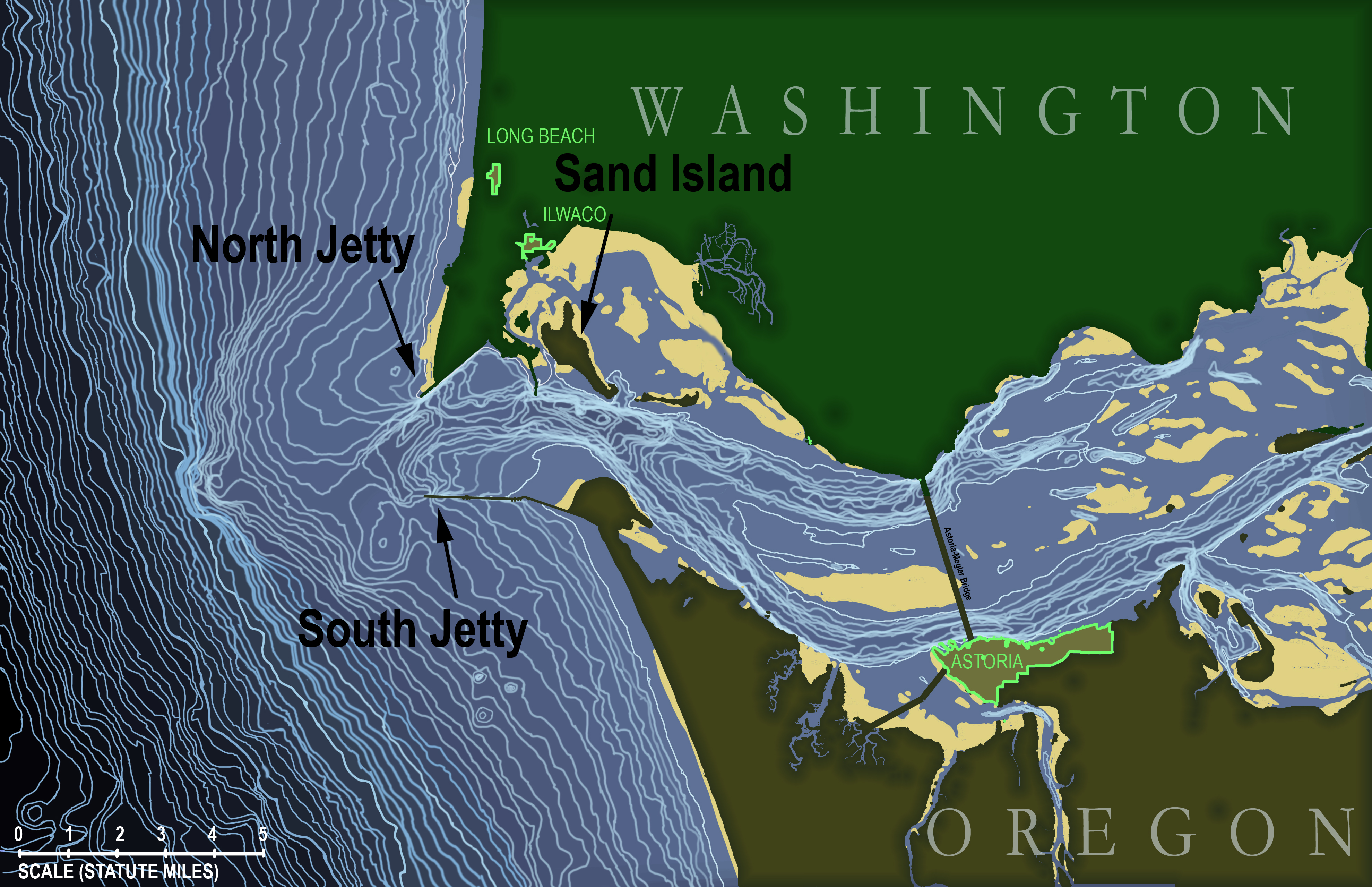
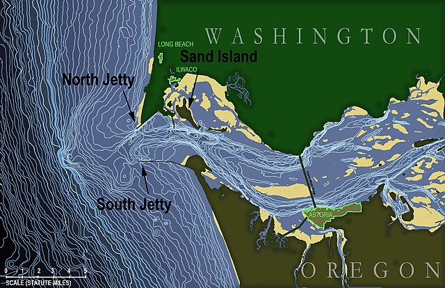
English: Topographic map of the underwater area in and around the mouth of the Columbia River in the state of Oregon, USA. Map is based on soundings in feet taken by the National Oceanic and Atmospheric Administration and published in NOAA navigational chart #18521, "Columbia River - Pacific Ocean to Harrington Point", August 2009 (original chart available here: http://www.charts.noaa.gov/OnLineViewer/18521.shtml) which itself is a public domain image.
Topographic lines on this map begin at a depth of 15 feet and occur at 5-foot intervals continuously down to 310 feet (i.e., the edge of the map). Land masses (states of Washington and Oregon) are shown in dark green with urbanized areas highlighted around the edge in bright green. Tidal sand bars are shown in yellow. Français : Carte topographique de l'estuaire et de la zone sous-marine périphérique à l'embouchure du fleuve Columbia dans l'état de l'Oregon, aux États-Unis. D'après les données de laNOAA (Administration nationale des océans et de l'atmosphère ; carte de navigation n ° 18521, "Fleuve Columbia - océan Pacifique à Harrington Point", août 2009 ; la carte originale est disponible ici: http://www.charts.noaa.gov/OnLineViewer/18521.shtml, elle-même publiée sous licence domaine public). Les lignes topographiques commencent à une profondeur de 15 pieds et apparaissent à intervalles de 5 pieds de manière continue jusqu'à 310 pieds (bord gauche de la carte). Les masses continentales (États de Washington et de l'Oregon) apparaissent en vert foncé avec les zones urbanisées surlignées en vert clair. Les bancs de sable de marée sont indiquées en jaune. |
| תאריך יצירה | |
| מקור | נוצר על־ידי מעלה היצירה |
| יוצר | KDS444 |
רישיון
אני, בעל זכויות היוצרים על עבודה זו, מפרסם בזאת את העבודה תחת הרישיון הבא:
הקובץ הזה מתפרסם לפי תנאי רישיון קריאייטיב קומונז ייחוס-שיתוף זהה 3.0 לא מותאם.
- הנכם רשאים:
- לשתף – להעתיק, להפיץ ולהעביר את העבודה
- לערבב בין עבודות – להתאים את העבודה
- תחת התנאים הבאים:
- ייחוס – יש לתת ייחוס הולם, לתת קישור לרישיון, ולציין אם נעשו שינויים. אפשר לעשות את זה בכל צורה סבירה, אבל לא בשום צורה שמשתמע ממנה שמעניק הרישיון תומך בך או בשימוש שלך.
- שיתוף זהה – אם תיצרו רמיקס, תשנו, או תבנו על החומר, חובה עליכם להפיץ את התרומות שלך לפי תנאי רישיון זהה או תואם למקור.
היסטוריית הקובץ
ניתן ללחוץ על תאריך/שעה כדי לראות את הקובץ כפי שנראה באותו זמן.
| תאריך/שעה | תמונה ממוזערת | ממדים | משתמש | הערה | |
|---|---|---|---|---|---|
| נוכחית | 02:38, 19 בדצמבר 2012 | | 2,557 × 3,957 (4.04 מ"ב) | KDS444 | Added labels for the towns of Ilwaco and Long Beach, Washington, and made labels for North Jetty, South Jetty, and Sand Island more visible in thumbnail view. |
| 15:57, 16 בדצמבר 2012 |  | 2,557 × 3,957 (4.05 מ"ב) | KDS444 | Added labels for jetties and Sand Island | |
| 15:27, 16 בדצמבר 2012 |  | 2,557 × 3,957 (4.03 מ"ב) | KDS444 | Added all contour lines down to 310 ft. | |
| 22:20, 15 באוגוסט 2012 |  | 582 × 900 (472 ק"ב) | KDS444 | corrections | |
| 23:37, 12 באוגוסט 2012 |  | 775 × 1,200 (697 ק"ב) | KDS444 |
שימוש בקובץ
הדף הבא משתמש בקובץ הזה:
שימוש גלובלי בקובץ
אתרי הוויקי השונים הבאים משתמשים בקובץ זה:
- שימוש באתר ca.wikipedia.org
- שימוש באתר en.wikipedia.org
- שימוש באתר fr.wikipedia.org
- שימוש באתר ht.wikipedia.org
- שימוש באתר www.wikidata.org