
קובץ:US federal land.agencies.svg

גודל התצוגה המקדימה הזאת מסוג PNG של קובץ ה־SVG הזה: 776 × 600 פיקסלים. רזולוציות אחרות: 311 × 240 פיקסלים | 621 × 480 פיקסלים | 994 × 768 פיקסלים | 1,280 × 989 פיקסלים | 2,560 × 1,978 פיקסלים | 990 × 765 פיקסלים.
לקובץ המקורי (קובץ SVG, הגודל המקורי: 990 × 765 פיקסלים, גודל הקובץ: 3.65 מ"ב)
| זהו קובץ שמקורו במיזם ויקישיתוף. תיאורו בדף תיאור הקובץ המקורי (בעברית) מוצג למטה. |
Department of Defense (includes Army Corps of Engineers projects)
Other agencies
תקציר
| תיאור |
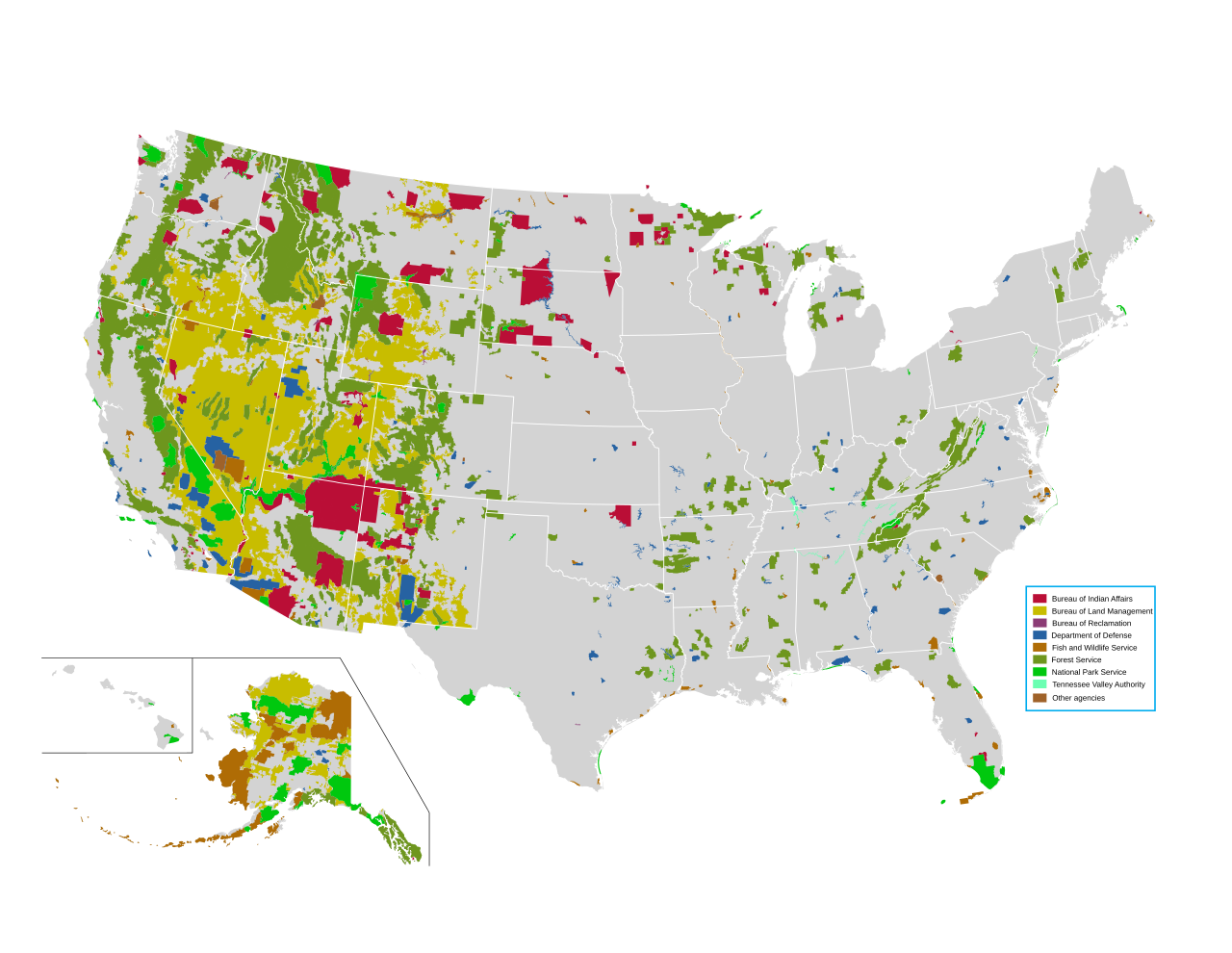
English: Map of all federally owned land in the United States. |
| מקור | http://nationalatlas.gov/printable/fedlands.html, "All Federal and Indian Lands" |
| יוצר | National Atlas of the United States |
רישיון
This map was obtained from an edition of the National Atlas of the United States. Like almost all works of the U.S. federal government, works from the National Atlas are in the public domain in the United States.
Online access: NationalAtlas.gov | 1970 print edition: Library of Congress, Perry-Castañeda Library
|
היסטוריית הקובץ
ניתן ללחוץ על תאריך/שעה כדי לראות את הקובץ כפי שנראה באותו זמן.
| תאריך/שעה | תמונה ממוזערת | ממדים | משתמש | הערה | |
|---|---|---|---|---|---|
| נוכחית | 01:42, 15 באפריל 2014 | | 765 × 990 (3.65 מ"ב) | Interiot~commonswiki | fix text alignment |
| 01:34, 15 באפריל 2014 |  | 765 × 990 (3.65 מ"ב) | Interiot~commonswiki | fix text alignment | |
| 01:27, 15 באפריל 2014 |  | 765 × 990 (3.65 מ"ב) | Interiot~commonswiki |
שימוש בקובץ
הדף הבא משתמש בקובץ הזה:
שימוש גלובלי בקובץ
אתרי הוויקי השונים הבאים משתמשים בקובץ זה:
- שימוש באתר en.wikipedia.org
- United States Forest Service
- Bureau of Land Management
- Public land
- Public domain (land)
- Sagebrush Rebellion
- Federal lands
- User:Kazkaskazkasako/Books/History
- Bundy standoff
- Grazing rights in Nevada
- Wikipedia:Reference desk/Archives/Humanities/2015 June 15
- Public lands in the United States
- Administrative state
- Environmental history of the United States
- שימוש באתר en.wikivoyage.org
- שימוש באתר fr.wikipedia.org
- שימוש באתר it.wikipedia.org
- שימוש באתר pt.wikipedia.org
- שימוש באתר ru.wikipedia.org
- שימוש באתר sv.wikipedia.org
- שימוש באתר zh.wikipedia.org