
קובץ:The map of the Holy Land by Marino Sanudo (drawn in 1320).jpg

לקובץ המקורי (1,950 × 1,272 פיקסלים, גודל הקובץ: 1.07 מ"ב, סוג MIME: image/jpeg)
| זהו קובץ שמקורו במיזם ויקישיתוף. תיאורו בדף תיאור הקובץ המקורי (בעברית) מוצג למטה. |
תקציר
| תיאור |
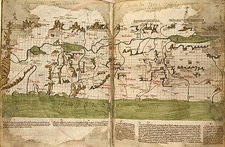
English: The map of the Holy Land by Marino Sanudo (drawn in 1320) Map orientation: north pointing left Latin text at bottom:[1] A: Tota terra a monte Libano per latus occidentale Jordanis vsque Capharnaum et inde per Saphet et Kabul et Toronum redeundo ad Libanum vocatur Yturea et Galilea superior et Galilea gentium et terra Kabul et terra Rob et saltus Libani et fuit pro magna parte de regione Decapoleos B: Tota terra a Tyberiade per Betsan et montem Effraym vsque Magedo et inde per capud Carmeli et montem Tabor et Betuliam vsque in Tyberiadem redeundo vocatur campus magnus Esdrelon vel campus Fabe, siue Magedo, vel Galilea inferior et planicies Galilee C: Tota terra a Cesarea Palestine vsque Joppen et inde transeundo per Tampnacsare et redeundo per Caco vsque Cesaream dicitur mons Effraym, licet sit terra campestris, et Saron, de quo dicitur Ysai. Factus est Saron sicut desertum, et est terra fertilis valde et pinguis habens villas multas et loca nemorosa et maxime circa Arsur suntque ibi leones multi et venationes regie E: Desertum Cades, vnde miserant filii Israel exploratores , qui post XL dies huc redierunt et murmurante populo jussi sunt redire in desertum per viam maris rubri et post XXX annos redierunt ad locum istum, vnde moventes castra contra orientem circuierunt montem Seyr et terram Amon et capta terra Seon, regis Osebon, et Og, regis Basan, venerunt ad Jordanem contra Jerico |
||
| תאריך יצירה | |||
| מקור |
Liber secretorum fidelium crucis by Marino Sanudo, c. 1321.
|
||
| יוצר | Marino Sanuto the Elder (c. 1260 – 1338); Pietro Vesconte |

.jpg)
.jpg?uselang=he)
רישיון
|
עבודת אמנות דו-מימדית זו המוצגת בתמונה שוחררה לרשות הציבור בכל העולם בעקבות תאריך מותו של היוצר, או תאריך פרסום היצירה. לפיכך, תצלום היצירה גם הוא ברשות הציבור.
הודעה זו תקפה לגבי התצלומים שנוצרו בארצות הברית, בגרמניה ובמדינות רבות נוספות.
| ||||
קובץ מדיה זה נמצא ברשות הציבור בארצות הברית. זה תקף לעבודות אמריקניות שבהן זכויות היוצרים פגו, לעתים מסיבה שהפרסום הראשון היה לפני 1 בינואר 1929. ראו דף זה להסבר נוסף.
|
 | |
 |
תמונה זו עשויה שלא להיות תחת רשות הציבור מחוץ לארצות הברית (זה נכון במיוחד במדינות ובאזורים שבהם לא חל rule of the shorter term עבור יצירות אמריקניות, ובהן קנדה, סין היבשתית (לא כולל הונג קונג ומקאו), גרמניה, מקסיקו, ושוויץ). היוצר ושנת הפרסום הם מידע חיוני שחובה לציין. ראו הסבר על רשות הציבור וזכויות יוצרים למידע נוסף.
|
היסטוריית הקובץ
ניתן ללחוץ על תאריך/שעה כדי לראות את הקובץ כפי שנראה באותו זמן.
| תאריך/שעה | תמונה ממוזערת | ממדים | משתמש | הערה | |
|---|---|---|---|---|---|
| נוכחית | 11:53, 8 ביולי 2017 | | 1,272 × 1,950 (1.07 מ"ב) | Onceinawhile | revert |
| 11:51, 8 ביולי 2017 |  | 1,272 × 1,950 (1.07 מ"ב) | Onceinawhile | cropped | |
| 11:41, 8 ביולי 2017 |  | 1,408 × 2,000 (1.18 מ"ב) | Onceinawhile | higher res | |
| 06:32, 6 במאי 2011 |  | 247 × 545 (58 ק"ב) | Geagea | == {{int:filedesc}} == {{Information |Description={{en|1=The map of the Holy Land by Marino Sanudo (drawn in 1320)}} |Source=[http://www.christusrex.org/www1/ofm/mad/articles/HarweyMaps.html www.christusrex.org] |Date=1320 |Author=[[:he::en:Marino Sa |
שימוש בקובץ
הדפים הבאים משתמשים בקובץ הזה:
שימוש גלובלי בקובץ
אתרי הוויקי השונים הבאים משתמשים בקובץ זה:
- שימוש באתר ar.wikipedia.org
- שימוש באתר arz.wikipedia.org
- שימוש באתר bn.wikipedia.org
- שימוש באתר ca.wikipedia.org
- שימוש באתר ckb.wikipedia.org
- שימוש באתר el.wikipedia.org
- שימוש באתר en.wikipedia.org
- Book of Joshua
- Israelites
- Holy Land
- Marino Sanuto the Elder
- History of cartography
- Historiography of the Crusades
- User:Onceinawhile
- Portal:Maps
- Cartography of Palestine
- Talk:Cartography of Palestine
- Template:Did you know nominations/Cartography of Palestine (region)
- Wikipedia:Recent additions/2020/April
- Wikipedia:Main Page history/2020 April 23
- Wikipedia:Did you know/Statistics/Monthly DYK pageview leaders/2020/April
- User:Mr. Ibrahem/map1
- שימוש באתר es.wikipedia.org
- שימוש באתר fa.wikipedia.org
- שימוש באתר fr.wikipedia.org
- שימוש באתר it.wikipedia.org
- שימוש באתר it.wikisource.org
- שימוש באתר ja.wikipedia.org
- שימוש באתר lmo.wikipedia.org
- שימוש באתר lt.wikipedia.org
- שימוש באתר nia.wikipedia.org
- שימוש באתר no.wikipedia.org
- שימוש באתר ro.wikipedia.org
- שימוש באתר sq.wikipedia.org
- שימוש באתר ta.wikipedia.org
- שימוש באתר vi.wikipedia.org
- שימוש באתר www.wikidata.org
.jpg)