
קובץ:Samoa geologic map.png
גודל התצוגה המקדימה הזאת: 800 × 351 פיקסלים. רזולוציות אחרות: 320 × 140 פיקסלים | 640 × 281 פיקסלים | 1,350 × 592 פיקסלים.
לקובץ המקורי (1,350 × 592 פיקסלים, גודל הקובץ: 171 ק"ב, סוג MIME: image/png)
| זהו קובץ שמקורו במיזם ויקישיתוף. תיאורו בדף תיאור הקובץ המקורי (בעברית) מוצג למטה. |
תקציר
| תיאור |
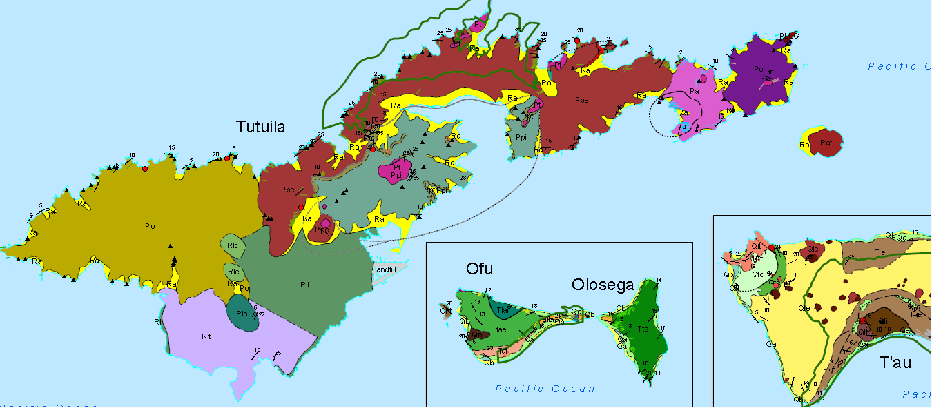
English: Samoa geologic map, where Volcanic Series are labeled as: Po for Taputapu, Rll and Rlt for Leone (Rla is an ash cone and Rlc is a cinder cone), Pa for Alofau, Pol for Olomoana, Ppe for Pago, and Ppi for Pago Intra-Caldera. Pt are trachyte plugs and dikes, such as Matafao, Vatia, and Pioa ("the rainmaker"). Ra depicts beach sand and alluvium, while the green line is the national park boundary, and the dashed line is the boundary of the caldera. |
| תאריך יצירה | |
| מקור | National Park of American Samoa, Geologic Resource Evaluation Report, Natural Resource Report NPS/NRPC/GRD/NRR - 2008/25 |
| יוצר | National Park Service, US Dept. of the Interior |
רישיון
| This image or media file contains material based on a work of a National Park Service employee, created as part of that person's official duties. As a work of the U.S. federal government, such work is in the public domain in the United States. See the NPS website and NPS copyright policy for more information. |
היסטוריית הקובץ
ניתן ללחוץ על תאריך/שעה כדי לראות את הקובץ כפי שנראה באותו זמן.
| תאריך/שעה | תמונה ממוזערת | ממדים | משתמש | הערה | |
|---|---|---|---|---|---|
| נוכחית | 16:43, 26 באפריל 2017 | | 592 × 1,350 (171 ק"ב) | Pi3.124 | User created page with UploadWizard |
שימוש בקובץ
הדף הבא משתמש בקובץ הזה:
שימוש גלובלי בקובץ
אתרי הוויקי השונים הבאים משתמשים בקובץ זה:
- שימוש באתר en.wikipedia.org