
קובץ:Premongol.png
אין גרסה ברזולוציה גבוהה יותר.
Premongol.png (752 × 590 פיקסלים, גודל הקובץ: 31 ק"ב, סוג MIME: image/png)
| זהו קובץ שמקורו במיזם ויקישיתוף. תיאורו בדף תיאור הקובץ המקורי (בעברית) מוצג למטה. |
תקציר

|
This map has been uploaded by Electionworld from en.wikipedia.org to enable the |
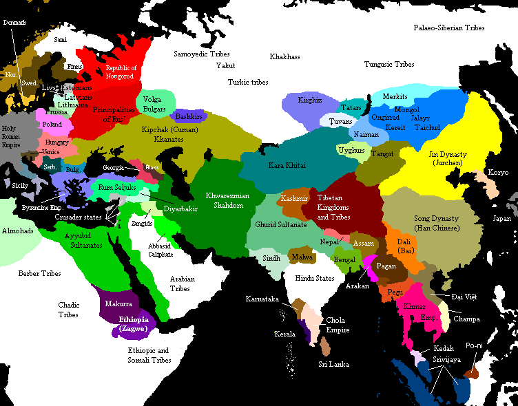
Eurasia on the eve of the Mongol invasions, c. 1200 CE. Source unknown. All of Central, North and East Asian states and tribes were located in wrong places.

|
יש ליצור מחדש את התמונה historical map הזו באמצעות גרפיקה וקטורית כדוגמת קובץ SVG. לפעולה זו מספר יתרונות, כפי שניתן לקרוא (באנגלית) בדף Commons:Media for cleanup. אם ברשותכם קובץ SVG, אנא העלו אותו. לאחר מכן, החליפו תבנית זו בתבנית
{{vector version available|שם הקובץ.svg}} |
רישיון

|
מוענקת בכך הרשות להעתיק, להפיץ או לשנות את המסמך הזה, לפי תנאי הרישיון לשימוש חופשי במסמכים של גנו, גרסה 1.2 או כל גרסה מאוחרת יותר שתפורסם על־ידי המוסד לתוכנה חופשית; ללא פרקים קבועים, ללא טקסט עטיפה קדמית וללא טקסט עטיפה אחורית. עותק של הרישיון כלול בפרק שכותרתו הרישיון לשימוש חופשי במסמכים של גנו. |
| הקובץ הזה מתפרסם לפי תנאי רישיון קריאייטיב קומונז ייחוס-שיתוף זהה 3.0 לא מותאם. | ||
| ||
| תבנית רישוי זו הוספה לקובץ כחלק מעדכון רישיון GFDL. |
See also

Original upload notes
20:43, 21 November 2006 . . Timmie.merc (talk | contribs | block) 752 × 590 (31,383 bytes) (Reverted to earlier revision)
20:42, 21 November 2006 . . Timmie.merc (talk | contribs | block) 752 × 590 (31,383 bytes) (Reverted to earlier revision)
17:31, 3 October 2006 . . Vilniškis (talk | contribs | block) 752 × 590 (31,383 bytes) (Eurasia on the eve of the Mongol invasions, c. 1200.)
17:26, 3 October 2006 . . Vilniškis (talk | contribs | block) 752 × 590 (31,383 bytes)
18:11, 26 September 2006 . . Nanshu (talk | contribs | block) 752 × 590 (20,501 bytes) (minor corrections on East Asia)
20:35, 6 June 2006 . . Foobaz (talk | contribs | block) 752 × 590 (20,505 bytes) (Changed name of Vietnam from Annam to Đại Việt as talk page suggested.)
12:26, 1 June 2006 . . Foobaz (talk | contribs | block) 752 × 590 (20,469 bytes) (fixed spelling error in Africa: "Berber Trubes" -> "Berber Tribes")
00:26, 14 January 2006 . . Briangotts (talk | contribs | block) 752 × 590 (45,292 bytes) (Eurasia on the eve of the Mongol invasions, c. 1200 CE. Category:Historical maps by User:Briangotts)
10:42, 22 December 2005 . . Briangotts (talk | contribs | block) 752 × 590 (44,927 bytes) (Eurasia on the eve of the Mongol invasions, c. 1200 CE. Category:Historical maps by User:Briangotts)
| Annotations | This image is annotated: View the annotations at Commons |
היסטוריית הקובץ
ניתן ללחוץ על תאריך/שעה כדי לראות את הקובץ כפי שנראה באותו זמן.
| תאריך/שעה | תמונה ממוזערת | ממדים | משתמש | הערה | |
|---|---|---|---|---|---|
| נוכחית | 16:27, 29 בספטמבר 2019 | | 590 × 752 (31 ק"ב) | Бмхүн | incorrect{{DEFAULTSORT:<noinclude></noinclude>}} |
| 22:04, 22 בנובמבר 2018 |  | 590 × 752 (31 ק"ב) | Spiridon Ion Cepleanu | Reverted to version as of 19:35, 27 March 2014 (UTC) | |
| 23:59, 8 במרץ 2015 |  | 1,903 × 3,240 (6.82 מ"ב) | Spiridon Ion Cepleanu | Modification after discussion with Khorichar and verifications in the Westermann Grosser Atlas zur Weltgeschichte (H.E.Stier, dir.), 1985. Perhaps new ameliorations may be tried. | |
| 17:49, 3 במרץ 2015 |  | 590 × 752 (24 ק"ב) | Spiridon Ion Cepleanu | New precisions according with Khorichar's rectifications [https://commons.wikimedia.org/wiki/User_talk:Khorichar] | |
| 20:40, 11 בדצמבר 2014 |  | 590 × 752 (24 ק"ב) | Spiridon Ion Cepleanu | Some little details according with H.E.Stier (dir.) « Grosser Atlas zur Weltgeschichte », Westermann 1985, ISBN 3-14-100919-8, « Putzger historischer Weltatlas Cornelsen » 1990, ISBN 3-464-00176-8 & some other works. | |
| 22:35, 27 במרץ 2014 |  | 590 × 752 (31 ק"ב) | Comnenus | Reverted to version as of 06:43, 5 March 2012 | |
| 14:44, 4 באוגוסט 2012 |  | 590 × 752 (31 ק"ב) | محک | Tabaristan was Fals. | |
| 09:43, 5 במרץ 2012 |  | 590 × 752 (31 ק"ב) | Ecthelion83 | 1. Added more geographical accuracy to Korean Peninsula 2. Cleaned up some of the artifacts from previous edits (i.e. spots of wrong color) 3. This map is meant to depict the Old World prior to the rise of the Mongol Empire, i.e. before the year 1190, ... | |
| 09:43, 5 במרץ 2012 |  | 590 × 752 (137 ק"ב) | Ecthelion83 | 1. Added more geographical accuracy to Korean Peninsula 2. Cleaned up some of the artifacts from previous edits (i.e. spots of wrong color) 3. This map is meant to depict the Old World prior to the rise of the Mongol Empire, i.e. before the year 1190, ... | |
| 17:44, 21 בספטמבר 2011 |  | 590 × 752 (137 ק"ב) | Comnenus | Reverted to version as of 18:29, 20 August 2011 Venice did not rule those territories in 1200. |
שימוש בקובץ
![]() אין בוויקיפדיה דפים המשתמשים בקובץ זה.
אין בוויקיפדיה דפים המשתמשים בקובץ זה.
שימוש גלובלי בקובץ
אתרי הוויקי השונים הבאים משתמשים בקובץ זה:
- שימוש באתר ar.wikipedia.org
- שימוש באתר azb.wikipedia.org
- שימוש באתר ca.wikipedia.org
- שימוש באתר de.wikipedia.org
- שימוש באתר de.wikiversity.org
- שימוש באתר en.wikipedia.org
- שימוש באתר en.wikibooks.org
- שימוש באתר es.wikipedia.org
- שימוש באתר et.wikipedia.org
- שימוש באתר fa.wikipedia.org
- שימוש באתר fr.wikipedia.org
- שימוש באתר hi.wikipedia.org
- שימוש באתר it.wikipedia.org
- שימוש באתר mn.wikipedia.org
- שימוש באתר pnb.wikipedia.org
- שימוש באתר ru.wikipedia.org
- שימוש באתר ta.wikipedia.org
- שימוש באתר tl.wikipedia.org
- שימוש באתר www.wikidata.org