
קובץ:Noord-Brabant position.svg

גודל התצוגה המקדימה הזאת מסוג PNG של קובץ ה־SVG הזה: 200 × 236 פיקסלים. רזולוציות אחרות: 203 × 240 פיקסלים | 407 × 480 פיקסלים | 651 × 768 פיקסלים | 868 × 1,024 פיקסלים | 1,736 × 2,048 פיקסלים.
לקובץ המקורי (קובץ SVG, הגודל המקורי: 200 × 236 פיקסלים, גודל הקובץ: 158 ק"ב)
| זהו קובץ שמקורו במיזם ויקישיתוף. תיאורו בדף תיאור הקובץ המקורי (בעברית) מוצג למטה. |
תקציר
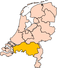
| תיאור | Location of the province of Noord-Brabant (North Brabant) in the Netherlands. |
| תאריך יצירה | |
| מקור | Own work, based on freely available GIS data |
| יוצר | User:Mtcv |
| אישורים והיתרים (שימוש חוזר בקובץ זה) |
Data: attribution required; my work: PD |
| גרסאות אחרות | I attempted to make an svg version of Image:Noord Brabant-Position.png (with less simplified boundaries) |
Clickable version

רישיון

|
בעלי זכויות היוצרים על הקובץ הזה, Centraal Bureau voor de Statistiek, מאשרים לכולם להשתמש בו לכל מטרה, בתנאי שניתן לבעלי הזכויות ייחוס נאות. הפצה, יצירות נגזרות, שימושים מסחריים וכל שימוש אחר מותרים. |
|
|
| Annotations | This image is annotated: View the annotations at Commons |


היסטוריית הקובץ
ניתן ללחוץ על תאריך/שעה כדי לראות את הקובץ כפי שנראה באותו זמן.
| תאריך/שעה | תמונה ממוזערת | ממדים | משתמש | הערה | |
|---|---|---|---|---|---|
| נוכחית | 20:20, 2 במרץ 2019 | | 236 × 200 (158 ק"ב) | Thayts | update |
| 03:49, 3 באוקטובר 2006 |  | 236 × 200 (158 ק"ב) | Mtcv | {{Information| |Description=Location of the province of Noord-Holland (North Holland) in the Netherlands. |Source=Own work, based on freely available GIS data |Date=2006-10-03 |Author=User:Mtcv |Permission=Data: attribution required; my work: PD |othe |
שימוש בקובץ
![]() אין בוויקיפדיה דפים המשתמשים בקובץ זה.
אין בוויקיפדיה דפים המשתמשים בקובץ זה.
שימוש גלובלי בקובץ
אתרי הוויקי השונים הבאים משתמשים בקובץ זה:
- שימוש באתר ar.wikipedia.org
- شمال بربنت
- آيندهوفن
- بريدا
- بارله ناساو
- تيلبورخ
- سيرتوخيمبوس
- قالب:بلديات شمال برابنت
- آلبورخ
- ألفن- كام
- أستن
- بيرخ آيك
- فيلدهوفن
- بيرخن أوب زووم
- بيرنهيزه
- بيست (هولندا)
- بلادل
- بوكل
- بوكسمير
- بوكستل
- كرانندونك
- كاوك
- دورنه
- دونجن
- دريميلين
- إيرسل
- إيتن- لور
- خيرتراودنبيرخ
- خيلدروب- ميرلو
- خيميرت- باكل
- خيلزه آن راين
- خورلا
- خرافه (هولندا)
- هارن (شمال برابنت)
- هالدربيرخه
- هيزه- لينده
- هيلموند
- هوسدن
- هيلفارينبيك
- لاربيك
- لانديرد
- لوب أوب زند
- مل آن سينت هوبرت
- موردايك
- نونن (خيرفن آن نيدرفيتن)
- أويرشخوت
- أويسترفايك
- أوسترهاوت
- أوس (هولندا)
- روسل- دي ميردن
- روسيندال