
קובץ:Netzarim junction map.png
גודל התצוגה המקדימה הזאת: 557 × 599 פיקסלים. רזולוציות אחרות: 223 × 240 פיקסלים | 446 × 480 פיקסלים | 674 × 725 פיקסלים.
לקובץ המקורי (674 × 725 פיקסלים, גודל הקובץ: 82 ק"ב, סוג MIME: image/png)
| זהו קובץ שמקורו במיזם ויקישיתוף. תיאורו בדף תיאור הקובץ המקורי (בעברית) מוצג למטה. |
תקציר

|
יש ליצור מחדש את התמונה locator map הזו באמצעות גרפיקה וקטורית כדוגמת קובץ SVG. לפעולה זו מספר יתרונות, כפי שניתן לקרוא (באנגלית) בדף Commons:Media for cleanup. אם ברשותכם קובץ SVG, אנא העלו אותו. לאחר מכן, החליפו תבנית זו בתבנית
{{vector version available|שם הקובץ.svg}} |
| תיאור |
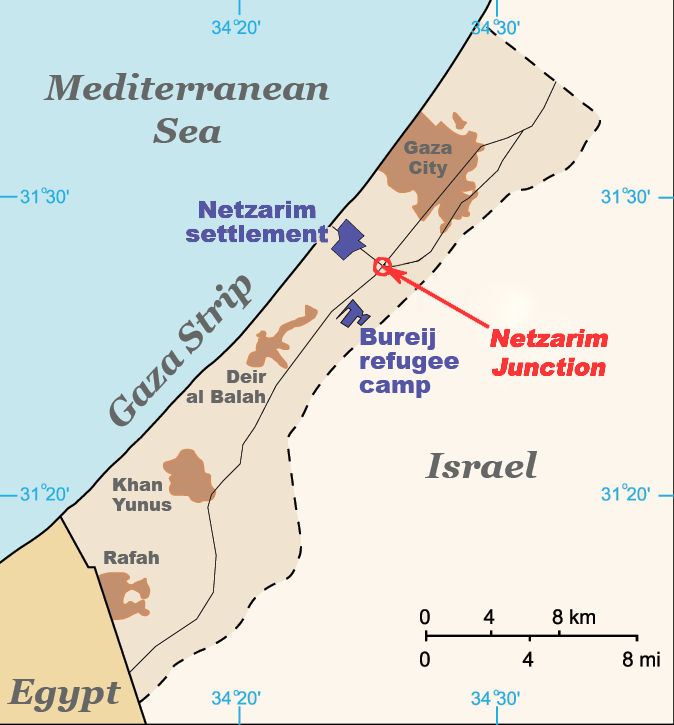
English: Map of the Gaza Strip indicating the locations of Bureij refugee camp, the former Netzarim settlement and the Netzarim Junction. Based on :Image:Gaza Strip map blank.svg. |
| תאריך יצירה | |
| מקור | נוצר על־ידי מעלה היצירה (טקסט מקורי: “I created this work entirely by myself.”) |
| יוצר | ChrisO (talk) |
רישיון
Vanished user 03 מוויקיפדיה האנגלית, בעל זכויות היוצרים על היצירה הזאת, מפרסם אותה בזאת תחת הרישיון הבא:
הקובץ הזה מתפרסם לפי תנאי רישיון קריאייטיב קומונז ייחוס-שיתוף זהה 3.0 לא מותאם.
ייחוס: Vanished user 03 מוויקיפדיה האנגלית
- הנכם רשאים:
- לשתף – להעתיק, להפיץ ולהעביר את העבודה
- לערבב בין עבודות – להתאים את העבודה
- תחת התנאים הבאים:
- ייחוס – יש לתת ייחוס הולם, לתת קישור לרישיון, ולציין אם נעשו שינויים. אפשר לעשות את זה בכל צורה סבירה, אבל לא בשום צורה שמשתמע ממנה שמעניק הרישיון תומך בך או בשימוש שלך.
- שיתוף זהה – אם תיצרו רמיקס, תשנו, או תבנו על החומר, חובה עליכם להפיץ את התרומות שלך לפי תנאי רישיון זהה או תואם למקור.
יומן העלאה מקורי
הועבר מ- en.wikipedia לוויקישיתוףעל ידי Magnus Manske באמצעות CommonsHelper.
תיאור הקובץ המקורי נמצא כאן. כל שמות המשתמשים הבאים מתייחסים ל-en.wikipedia.
- 2009-04-06 19:56 Jaakobou 674×725× (84061 bytes) Update by adding a marking and fixing colors to emphasize the junction where the al-Durrah event occurred.
- 2008-07-18 18:52 Vanished user 03 674×725× (28831 bytes) {{Information |Description=Map of the Gaza Strip indicating the locations of Bureij refugee camp, the former Netzarim settlement and the Netzarim Junction. Based on [[:Image:Gaza Strip map blank.svg]]. |Source=I created this work entirely by myself. |Date
היסטוריית הקובץ
ניתן ללחוץ על תאריך/שעה כדי לראות את הקובץ כפי שנראה באותו זמן.
| תאריך/שעה | תמונה ממוזערת | ממדים | משתמש | הערה | |
|---|---|---|---|---|---|
| נוכחית | 19:08, 19 בפברואר 2011 | | 725 × 674 (82 ק"ב) | File Upload Bot (Magnus Manske) | {{BotMoveToCommons|en.wikipedia|year={{subst:CURRENTYEAR}}|month={{subst:CURRENTMONTHNAME}}|day={{subst:CURRENTDAY}}}} {{Information |Description={{en|Map of the Gaza Strip indicating the locations of Bureij refugee camp, the former Netzarim settlement a |
שימוש בקובץ
הדף הבא משתמש בקובץ הזה:
שימוש גלובלי בקובץ
אתרי הוויקי השונים הבאים משתמשים בקובץ זה:
- שימוש באתר cy.wikipedia.org
- שימוש באתר en.wikipedia.org
- שימוש באתר es.wikipedia.org
- שימוש באתר id.wikipedia.org
- שימוש באתר pnb.wikipedia.org
- שימוש באתר ru.wikipedia.org
- שימוש באתר uk.wikipedia.org
- שימוש באתר ur.wikipedia.org
- שימוש באתר uz.wikipedia.org
- שימוש באתר vi.wikipedia.org
- שימוש באתר zh.wikipedia.org