
קובץ:Mardin districts.png

גודל התצוגה המקדימה הזאת: 776 × 600 פיקסלים. רזולוציות אחרות: 311 × 240 פיקסלים | 621 × 480 פיקסלים | 994 × 768 פיקסלים | 1,056 × 816 פיקסלים.
לקובץ המקורי (1,056 × 816 פיקסלים, גודל הקובץ: 25 ק"ב, סוג MIME: image/png)
| זהו קובץ שמקורו במיזם ויקישיתוף. תיאורו בדף תיאור הקובץ המקורי (בעברית) מוצג למטה. |
תקציר
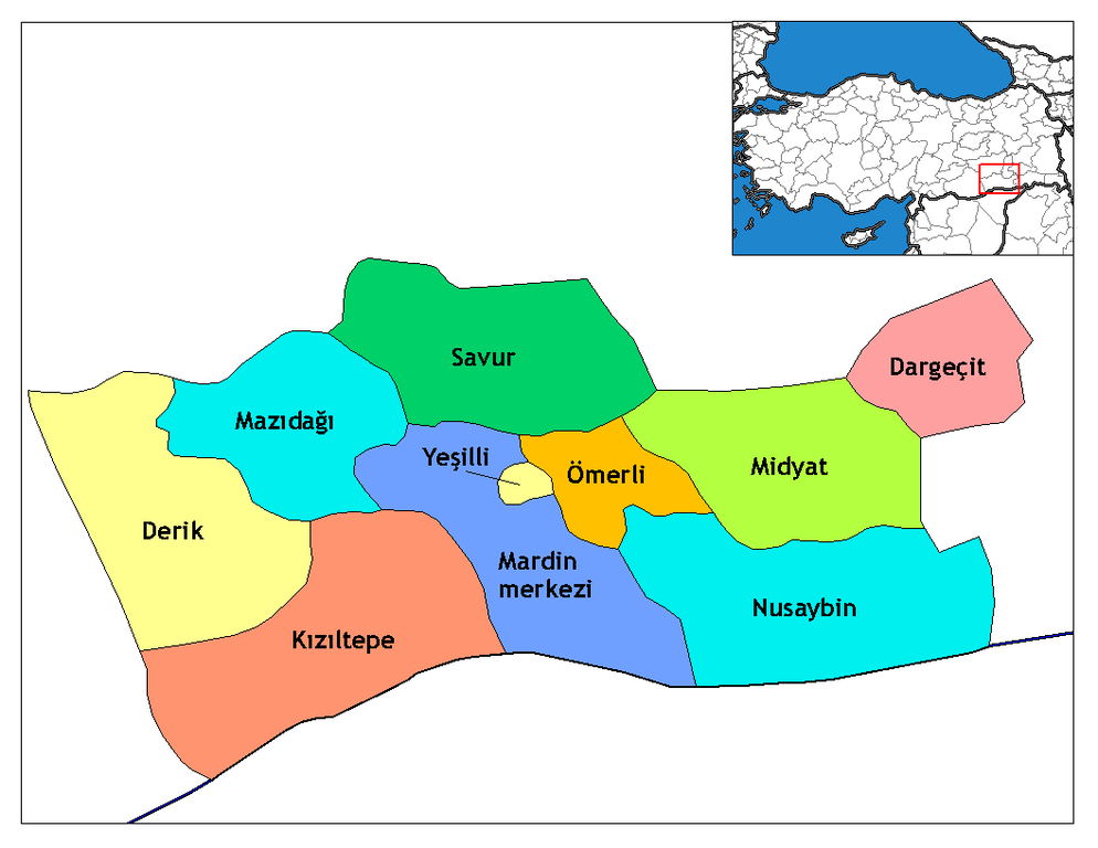
| תיאור | Map of the districts of Mardin province in Turkey. Created by Rarelibra 16:36, 4 December 2006 (UTC) for public domain use, using MapInfo Professional v8.5 and various mapping resources. Edited by One Homo Sapiens Corrected text where İ,Ş,ı,ğ,or ş occurs in name. Source: [statoids-com]. Increased font size and enhanced color differences among adjacent districts. |
| תאריך יצירה | 4 בדצמבר 2006 (תאריך העלאה מקורי) |
| מקור | לא סופק מקור מכונה קריא. ההנחה היא כי היצירה נוצרה על ידי מעלה היצירה (בהתבסס על תבנית הרישיון). |
| יוצר | לא סופק יוצר ששמו ניתן לקריאה במכונה. בהתבסס על תביעות זכויות יוצרים, ההנחה היא כי Rarelibra הוא היוצר. |
רישיון
| ברצוני, בעלי זכויות היוצרים על יצירה זו, לשחרר יצירה זו לנחלת הכלל. זה תקף בכל העולם. יש מדינות שבהן הדבר אינו אפשרי על פי חוק, אם כך: אני מעניק לכל אחד את הזכות להשתמש בעבודה זו לכל מטרה שהיא, ללא תנאים כלשהם, אלא אם כן תנאים כאלה נדרשים על פי חוק. |
היסטוריית הקובץ
ניתן ללחוץ על תאריך/שעה כדי לראות את הקובץ כפי שנראה באותו זמן.
| תאריך/שעה | תמונה ממוזערת | ממדים | משתמש | הערה | |
|---|---|---|---|---|---|
| נוכחית | 04:37, 29 בדצמבר 2008 | | 816 × 1,056 (25 ק"ב) | One Homo Sapiens | Corrected text where İ,Ş,ı,ğ,or ş occurs in name. Source: [statoids-com]. Increased font size and enhanced color differences among adjacent districts. |
| 19:36, 4 בדצמבר 2006 |  | 816 × 1,056 (30 ק"ב) | Rarelibra | Map of the districts of Mardin province in Turkey. Created by ~~~~ for public domain use, using MapInfo Professional v8.5 and various mapping resources. |
שימוש בקובץ
הדף הבא משתמש בקובץ הזה:
שימוש גלובלי בקובץ
אתרי הוויקי השונים הבאים משתמשים בקובץ זה:
- שימוש באתר ar.wikipedia.org
- שימוש באתר ast.wikipedia.org
- שימוש באתר az.wikipedia.org
- שימוש באתר be.wikipedia.org
- שימוש באתר bs.wikipedia.org
- שימוש באתר ca.wikipedia.org
- שימוש באתר ceb.wikipedia.org
- שימוש באתר cs.wikipedia.org
- שימוש באתר cy.wikipedia.org
- שימוש באתר diq.wikipedia.org
- שימוש באתר en.wikipedia.org
- שימוש באתר en.wiktionary.org
- שימוש באתר eo.wikipedia.org
- שימוש באתר es.wikipedia.org
- שימוש באתר eu.wikipedia.org
- שימוש באתר fa.wikipedia.org
- שימוש באתר fi.wikipedia.org
- שימוש באתר fr.wikipedia.org
- שימוש באתר fr.wikivoyage.org