
קובץ:Manama bahrain.jpg

גודל התצוגה המקדימה הזאת: 591 × 600 פיקסלים. רזולוציות אחרות: 236 × 240 פיקסלים | 473 × 480 פיקסלים | 757 × 768 פיקסלים | 1,009 × 1,024 פיקסלים | 2,017 × 2,048 פיקסלים | 3,968 × 4,028 פיקסלים.
לקובץ המקורי (3,968 × 4,028 פיקסלים, גודל הקובץ: 9.65 מ"ב, סוג MIME: image/jpeg)
| זהו קובץ שמקורו במיזם ויקישיתוף. תיאורו בדף תיאור הקובץ המקורי (בעברית) מוצג למטה. |
תקציר
| תיאור |
Español: Vista lateral de Bahréin desde el espacio
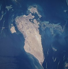
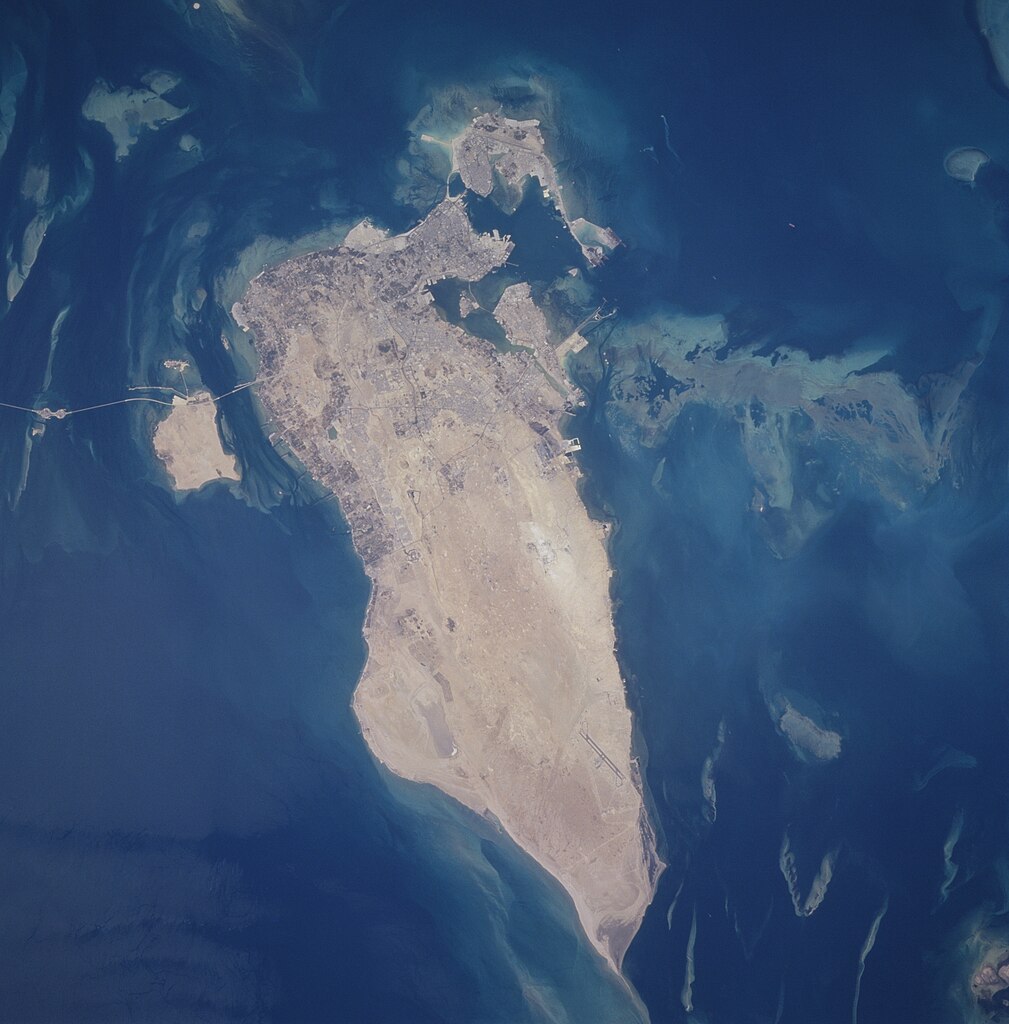
English: The capital city of Al Manamah, situated on the northeast tip of the island country of Bahrain, can be seen in this west-looking view. With a population of over 155000, Al Manamah is an international banking center with oil refineries, light industry, and is a duty free port. Tourism has also become a major industry. The main island of Bahrain is 30 miles (48 km) long north to south, and 10 miles (16 km) wide east to west. The island name comes from the Arabic word meaning "two seas". Bahrain is located 15 miles (24 km) off the eastern coast of Saudi Arabia in the Persian Gulf. The island is a low-lying barren desert with outcroppings of limestone that form low rolling hills, cliffs, and shallow ravines. The low rolling hills are called the Jabal Ad Dukhan (Mountains of Smoke) named for the mist that often wreathes the 543 foot-135 meters summit. Extending from the main island of Bahrain westward and exiting the view near the top center of the image is the causeway that connects Saudi Arabia to Bahrain. |
| תאריך יצירה | צולם ב- 25 ביוני 1996, 10:31:09 |
| מקור | https://eol.jsc.nasa.gov/SearchPhotos/photo.pl?mission=STS078&roll=748&frame=12 |
| יוצר | NASA/STS-78 |
| מיקום האובייקט | | תמונה זו ותמונות נוספות במיקום: OpenStreetMap |
|---|
This image or video was catalogued by Johnson Space Center of the United States National Aeronautics and Space Administration (NASA) under Photo ID: STS078-748-12. This tag does not indicate the copyright status of the attached work. A normal copyright tag is still required. See Commons:Licensing. Other languages:
|
תקציר
This file is in the public domain in the United States because it was created by the Image Science & Analysis Laboratory, of the NASA Johnson Space Center. NASA copyright policy states that "NASA material is not protected by copyright unless noted". (NASA media use guidelines or Conditions of Use of Astronaut Photographs).
Photo source: STS078-748-12.
|
היסטוריית הקובץ
ניתן ללחוץ על תאריך/שעה כדי לראות את הקובץ כפי שנראה באותו זמן.
| תאריך/שעה | תמונה ממוזערת | ממדים | משתמש | הערה | |
|---|---|---|---|---|---|
| נוכחית | 05:13, 27 בספטמבר 2020 | | 4,028 × 3,968 (9.65 מ"ב) | Huntster | Full resolution from NASA. |
| 08:00, 21 בפברואר 2010 |  | 640 × 630 (97 ק"ב) | Rehman | Align to North | |
| 01:40, 1 ביוני 2005 |  | 630 × 640 (85 ק"ב) | Taichi | Bahrein desde el espacio. NASA 1996 image description [http://eol.jsc.nasa.gov/sseop/EFS/photoinfo.pl?PHOTO=STS078-748-12 here] {{PD-USGov-NASA}} |
שימוש בקובץ
הדף הבא משתמש בקובץ הזה:
שימוש גלובלי בקובץ
אתרי הוויקי השונים הבאים משתמשים בקובץ זה:
- שימוש באתר af.wikipedia.org
- שימוש באתר en.wikipedia.org
- שימוש באתר eo.wikipedia.org
- שימוש באתר gl.wikipedia.org
- שימוש באתר hif.wikipedia.org
- שימוש באתר hr.wikipedia.org
- שימוש באתר id.wikipedia.org
- שימוש באתר lt.wikipedia.org
- שימוש באתר ms.wikipedia.org
- שימוש באתר pl.wikipedia.org
- שימוש באתר ro.wikipedia.org
- שימוש באתר sh.wikipedia.org
- שימוש באתר simple.wikipedia.org
- שימוש באתר tk.wikipedia.org
- שימוש באתר uk.wikipedia.org
- שימוש באתר zh.wikipedia.org