
קובץ:Greatvalley-map.png

גודל התצוגה המקדימה הזאת: 587 × 599 פיקסלים. רזולוציות אחרות: 235 × 240 פיקסלים | 624 × 637 פיקסלים.
לקובץ המקורי (624 × 637 פיקסלים, גודל הקובץ: 66 ק"ב, סוג MIME: image/png)
| זהו קובץ שמקורו במיזם ויקישיתוף. תיאורו בדף תיאור הקובץ המקורי (בעברית) מוצג למטה. |


|
יש ליצור מחדש את התמונה map הזו באמצעות גרפיקה וקטורית כדוגמת קובץ SVG. לפעולה זו מספר יתרונות, כפי שניתן לקרוא (באנגלית) בדף Commons:Media for cleanup. אם ברשותכם קובץ SVG, אנא העלו אותו. לאחר מכן, החליפו תבנית זו בתבנית
{{vector version available|שם הקובץ.svg}} |
תקציר
| תיאור |
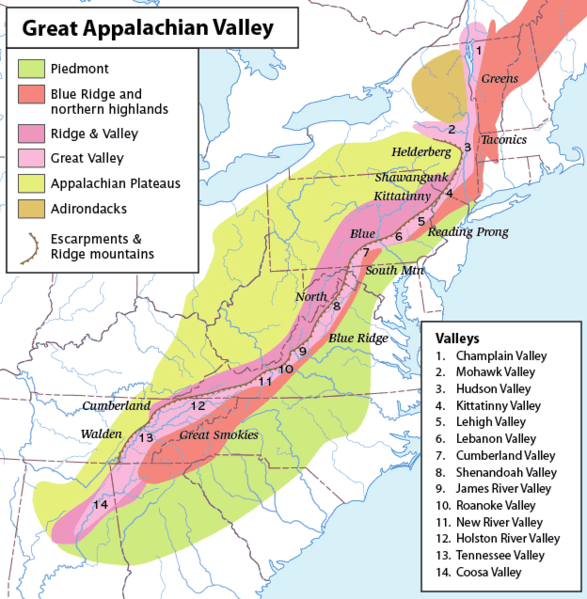
Map of the Appalachian Mountain physiographic regions, highlighting the Great Appalachian Valley, naming the main valleys making it up and the main mountains on either side. Legend:
|
| תאריך יצירה | (UTC) |
| מקור | |
| יוצר |
|
| זוהי תמונה מרוטשת, זאת אומרת שהתמונה שונתה בצורה דיגיטלית מהמקור. Modifications: converted loselessto PNG. את התמונה המקורית ניתן לראות ב: Greatvalley-map.jpg.
|
אני, בעל זכויות היוצרים על עבודה זו, מפרסם בזאת את העבודה תחת הרישיון הבא:
הקובץ הזה מתפרסם לפי תנאי רישיון קריאייטיב קומונז ייחוס-שיתוף זהה 2.5 כללי.
- הנכם רשאים:
- לשתף – להעתיק, להפיץ ולהעביר את העבודה
- לערבב בין עבודות – להתאים את העבודה
- תחת התנאים הבאים:
- ייחוס – יש לתת ייחוס הולם, לתת קישור לרישיון, ולציין אם נעשו שינויים. אפשר לעשות את זה בכל צורה סבירה, אבל לא בשום צורה שמשתמע ממנה שמעניק הרישיון תומך בך או בשימוש שלך.
- שיתוף זהה – אם תיצרו רמיקס, תשנו, או תבנו על החומר, חובה עליכם להפיץ את התרומות שלך לפי תנאי רישיון זהה או תואם למקור.
יומן העלאה מקורי
This image is a derivative work of the following images:
- File:Greatvalley-map.jpg licensed with Cc-by-sa-2.5
- 2006-11-14T06:22:37Z Pfly 624x637 (394372 Bytes) {{Information |Description=Map of the Appalachian Mountain physiographic regions, highlighting the Great Appalachian Valley, naming the main valleys making it up and the main mountains on either side. |Source=I made this map
Uploaded with derivativeFX
היסטוריית הקובץ
ניתן ללחוץ על תאריך/שעה כדי לראות את הקובץ כפי שנראה באותו זמן.
| תאריך/שעה | תמונה ממוזערת | ממדים | משתמש | הערה | |
|---|---|---|---|---|---|
| נוכחית | 18:00, 12 במאי 2010 | | 637 × 624 (66 ק"ב) | Perhelion | {{Information |Description=Map of the Appalachian Mountain physiographic regions, highlighting the Great Appalachian Valley, naming the main valleys making it up and the main mountains on either side. |Source=*File:Greatvalley-map.jpg |Date=2010-05- |
שימוש בקובץ
הדפים הבאים משתמשים בקובץ הזה:
שימוש גלובלי בקובץ
אתרי הוויקי השונים הבאים משתמשים בקובץ זה:
- שימוש באתר bg.wikipedia.org
- שימוש באתר bh.wikipedia.org
- שימוש באתר ca.wikipedia.org
- שימוש באתר cs.wikipedia.org
- שימוש באתר da.wikipedia.org
- שימוש באתר en.wikipedia.org
- Washington County, New York
- Great Appalachian Valley
- Allegheny Front
- Lehigh Valley
- Cumberland Valley
- Talk:Ridge-and-Valley Appalachians
- Lebanon Valley
- Kittatinny Valley
- Gaps of the Allegheny
- Template:User Appalachian diaspora
- User:Hike395/mountain bot diff
- Template:Infobox mountain/test versus status quo ante 3
- שימוש באתר et.wikipedia.org
- שימוש באתר fa.wikipedia.org
- שימוש באתר fo.wikipedia.org
- שימוש באתר frr.wikipedia.org
- שימוש באתר fr.wikipedia.org
- שימוש באתר it.wikipedia.org
- שימוש באתר ja.wikipedia.org
- שימוש באתר lt.wikipedia.org
- שימוש באתר ml.wikipedia.org
- שימוש באתר pl.wikipedia.org
- שימוש באתר simple.wikipedia.org
- שימוש באתר uk.wikipedia.org