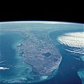
קובץ:Florida STS51C-44-26.jpg

תוכן הדף אינו נתמך בשפות אחרות.
מתוך ויקיפדיה, האנציקלופדיה החופשית

לקובץ המקורי(4,095 × 4,095 פיקסלים, גודל הקובץ: 3.34 מ"ב, סוג MIME‏: image/jpeg)

ויקישיתוף זהו קובץ שמקורו במיזם ויקישיתוף. תיאורו בדף תיאור הקובץ המקורי (בעברית) מוצג למטה.

תקציר

תיאור
English: Florida Peninsula, January 1985
English: The Gulf of Mexico and the Gulf Stream bracket the Florida Peninsula on the west and east. The lighter shade of blue in the Gulf of Mexico is due to the much shallower (continental shelf) water depths of less than 200 feet (60 meters), whereas the much darker blue of the Gulf Stream is due to water depths in excess of 2000 feet (610 meters). Tampa Bay and Charlotte Harbor are fairly large water embayments along the west coast, and Lake Okeechobee is the large body of water in the south-central part of the state. Numerous smaller lakes can also be seen generally extending north and south through the central part of the state. Practically all of the lakes in central Florida have been created by the interaction of water with the limestone rock that underlies most of the state. Thus, through time, sinkholes have developed, occasionally swallowing houses and roads as the limestone rock collapses. This type of topography is termed "karst." Visible along the southeastern coast of Florida is a large urban area that stretches roughly from Homestead in the south to beyond West Palm Beach in the north (including the greater Miami area). This built-up area is known as the "Gold Coast" of Florida. To the west of this vibrant and ever-growing urban area is the vast, relatively uniform-looking swampland of the Everglades, which is virtually uninhabited by humans. In fact, most of the flat, saw grass landscape is occasionally interrupted by small stands of hardwood hammocks; this area is part of the Big Cypress National Preserve and the Everglades National Park. Most of the Florida Keys are visible as they form an archipelago that arcs to the southwest from the southern tip of Florida. Also visible are parallel lines of clouds that have been formed as a cool air mass from the northwest is pushed across the warmer water of the Gulf Stream. A very faint smoke plume that originates near the Georgia-South Carolina border provides a clue to the wind direction at the time this photograph was taken.
תאריך יצירה
מקור NASA Image and Video Library JSC Gateway to Astronaut Photography of Earth
יוצר NASA
Camera
InfoField
Hasselblad
Focal length
InfoField
100 mm
Film
InfoField
5017: Kodak, natural color positive, Ektachrome, X Professional, ASA 64, standard base
Content Provider
InfoField
Kamlesh P. Lulla Ph.D. Chief, Earth Sciences Branch
Responsible NASA Official
InfoField
Ed Wilson
Curator
InfoField
Jaime Powell
מיקום המצלמה20° 54′ 00″ N, 79° 30′ 00″ W Kartographer map based on OpenStreetMap.תמונה זו ותמונות נוספות במיקום: OpenStreetMapinfo
מיקום האובייקט27° 00′ 00″ N, 81° 00′ 00″ W Kartographer map based on OpenStreetMap.תמונה זו ותמונות נוספות במיקום: OpenStreetMapinfo
This image or video was catalogued by Johnson Space Center of the United States National Aeronautics and Space Administration (NASA) under Photo ID: STS51C-44-26 and Alternate ID: 51C-44-026.

This tag does not indicate the copyright status of the attached work. A normal copyright tag is still required. See Commons:Licensing.
Other languages:

רישיון

Public domain קובץ זה נמצא ברשות הציבור מכיוון שהוא נוצר על ידי נאס"א. מדיניות זכויות היוצרים של נאס"א קובעת ש"חומרים של NASA אינם מוגנים בזכויות יוצרים אלא אם צוין אחרת". (דף מדיניות זכויות היוצרים ב-NASA או מדיניות שימוש בתמונות ב-JPL).
אזהרות:
  • שימוש בלוגואים, סמלים וטלאים של נאס"א כפוף להגבלה של החוק בארצות הברית 14 CFR 1221.
  • אתר האינטרנט של נאס"א מכיל תמונות רבות שמקורן מתוכנית החלל הסובייטית/סוכנות החלל הרוסית, וחומרים נוספים של סוכנויות חלל אחרות. קבצים אלו אינם בהכרח תחת רשות הציבור.
  • חומרים מטלסקופ החלל האבל עשויים להיות מוגנים בזכויות יוצרים אם לא מצוין במפורש שהגיעו מSTScI. [1]
  • כל החומרים שנוצרו על ידי חללית SOHO מוגנים בזכויות יוצרים ודורשים הרשאה עבור שימוש מסחרי לא חינוכי. [2]
  • תמונות המוצגות באתר Astronomy Picture of the Day (APOD) עשויים להיות מוגנים בזכויות יוצרים. [3]

כיתובים

נא להוסיף משפט שמסביר מה הקובץ מייצג
Florida Peninsula, January 1985

100 מילימטר

היסטוריית הקובץ

ניתן ללחוץ על תאריך/שעה כדי לראות את הקובץ כפי שנראה באותו זמן.

תאריך/שעהתמונה ממוזערתממדיםמשתמשהערה
נוכחית16:24, 14 בפברואר 2021תמונה ממוזערת לגרסה מ־16:24, 14 בפברואר 2021‪4,095 × 4,095‬ (3.34 מ"ב)AskeuhdHigher resolution version
12:25, 1 בספטמבר 2005תמונה ממוזערת לגרסה מ־12:25, 1 בספטמבר 2005‪608 × 640‬ (80 ק"ב)Roger469 == Fonte == Earth.Jonhson Space Center.National Aeronautic and Space Administration.government/Space Shuttle Earth Observations Photography/Earth From Space/low resolution.[ http://earth.jsc.nasa.gov/sseop/efs/lores.pl?PHOTO= STS51C-44-26 Florida – Cal

הדף הבא משתמש בקובץ הזה:

שימוש גלובלי בקובץ

אתרי הוויקי השונים הבאים משתמשים בקובץ זה: