
קובץ:Cessetani location map-blank.svg

גודל התצוגה המקדימה הזאת מסוג PNG של קובץ ה־SVG הזה: 800 × 600 פיקסלים. רזולוציות אחרות: 320 × 240 פיקסלים | 640 × 480 פיקסלים | 1,024 × 768 פיקסלים | 1,280 × 960 פיקסלים | 2,560 × 1,920 פיקסלים | 1,140 × 855 פיקסלים.
לקובץ המקורי (קובץ SVG, הגודל המקורי: 1,140 × 855 פיקסלים, גודל הקובץ: 514 ק"ב)
| זהו קובץ שמקורו במיזם ויקישיתוף. תיאורו בדף תיאור הקובץ המקורי (בעברית) מוצג למטה. |
תקציר
| תיאור |
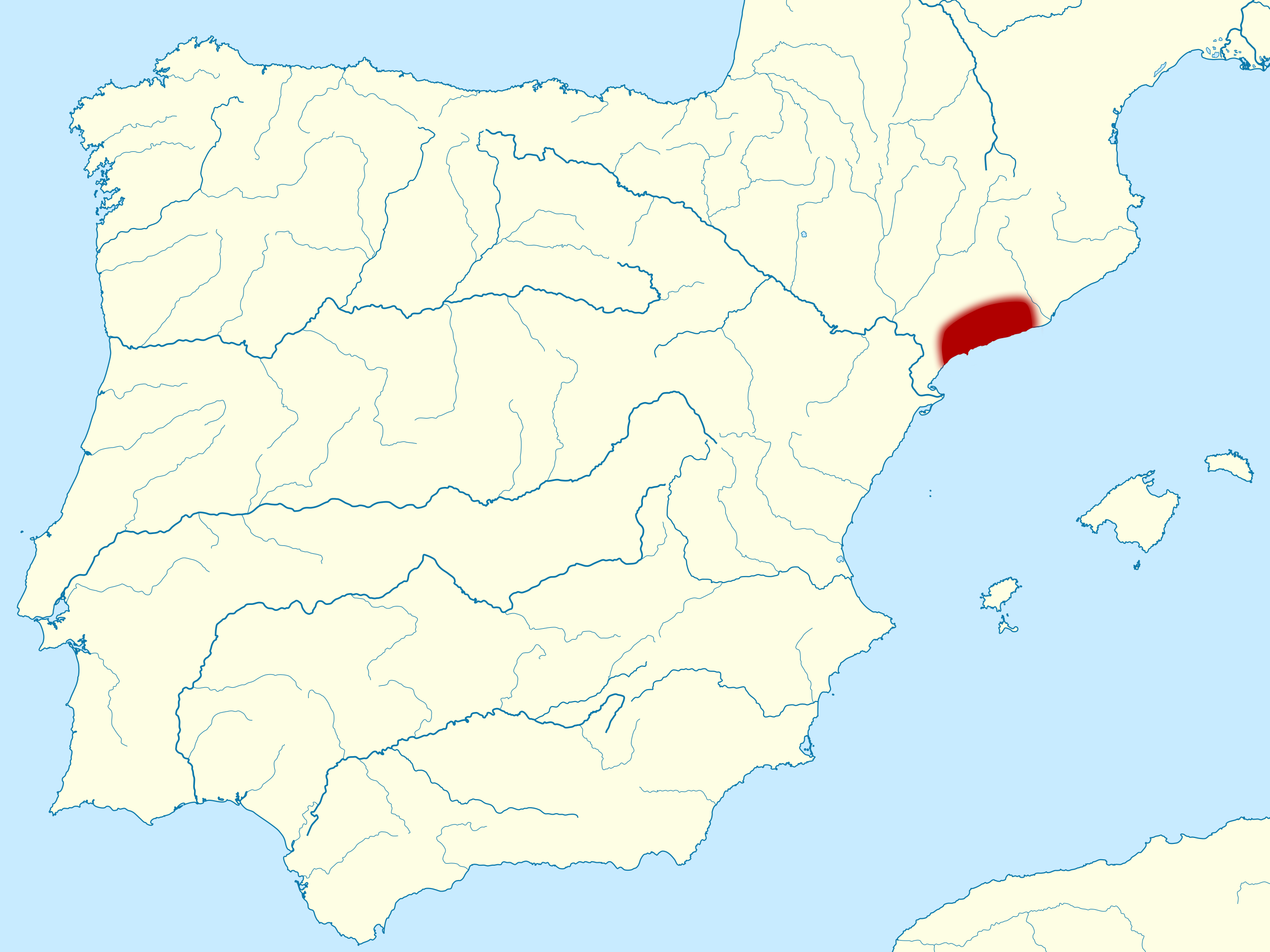
English: Location map of the pre-Roman people of Cessetani in Iberian peninsula, along the coast between the Coll de Balaguer and the Garraf Massif, and limited in the west by the Prades Mountains. Français : Carte de localisation du peuple Cessetani dans la péninsule Ibérique. Ce peuple vivait avant la conquête romaine le long de la côte entre le Col de Balaguer au sud, jusqu'au Massif de Garraf au nord, la sierra d'Argentera et les montagnes de Prades à l'ouest, et la sierra de la Llacuna et de Puigfred au nord-ouest. |
| תאריך יצירה | (UTC) |
| מקור | |
| יוצר |
|
| ייחוס (required by the license) | © Sémhur / Wikimedia Commons / |
| מיקום המצלמה | | תמונה זו ותמונות נוספות במיקום: OpenStreetMap |
|---|
W3C-validity not checked.
. Inkscape עם נוצרה ה תמונה
רישיון
אני, בעל זכויות היוצרים על היצירה הזאת, מפרסם אותה בזאת תחת הרישיונות הבאים:
| יוצרים זכויות (copyleft): יצירת האמנות הזאת חופשית; מותר לך להפיץ אותה או לשנות לפי תנאי רישיון אמנות חופשית (Free Art License). אפשר למצוא עותק של הרישיון הזה באתר Copyleft Attitude כמו גם באתרים אחרים. |
This file is licensed under the Creative Commons Attribution-Share Alike 4.0 International, 3.0 Unported, 2.5 Generic, 2.0 Generic and 1.0 Generic license.
- הנכם רשאים:
- לשתף – להעתיק, להפיץ ולהעביר את העבודה
- לערבב בין עבודות – להתאים את העבודה
- תחת התנאים הבאים:
- ייחוס – יש לתת ייחוס הולם, לתת קישור לרישיון, ולציין אם נעשו שינויים. אפשר לעשות את זה בכל צורה סבירה, אבל לא בשום צורה שמשתמע ממנה שמעניק הרישיון תומך בך או בשימוש שלך.
- שיתוף זהה – אם תיצרו רמיקס, תשנו, או תבנו על החומר, חובה עליכם להפיץ את התרומות שלך לפי תנאי רישיון זהה או תואם למקור.
הנכם מוזמנים לבחור את הרישיון הרצוי בעיניכם.
יומן העלאה מקורי
This image is a derivative work of the following images:
- File:Catiberica.svg licensed with PD-self
- 2007-07-12T23:51:52Z HansenBCN 887x902 (463187 Bytes) {{Information |Description= Pre-Roman peoples in Catalonia, boundaries map |Source= Own map |Date= July 13th 2007 |Author= Hansen |Permission= }} [[Category:History of Catalonia]]
- 2007-07-12T23:34:57Z HansenBCN 2500x2542 (474751 Bytes) {{Information |Description=Pre-Roman peoples in Catalonia |Source= |Date= |Author= Hansen |Permission= |other_versions= }} [[Category:History of Catalonia]]
- File:Via_Augusta_map-fr.svg licensed with Cc-by-sa-3.0,2.5,2.0,1.0, FAL
- 2011-07-27T08:12:03Z Sémhur 1261x1051 (567874 Bytes)
Uploaded with derivativeFX
היסטוריית הקובץ
ניתן ללחוץ על תאריך/שעה כדי לראות את הקובץ כפי שנראה באותו זמן.
| תאריך/שעה | תמונה ממוזערת | ממדים | משתמש | הערה | |
|---|---|---|---|---|---|
| נוכחית | 09:53, 18 ביולי 2013 | | 855 × 1,140 (514 ק"ב) | Citypeek | Saved in plain svg. Valid SVG now. |
| 22:01, 7 באוגוסט 2011 |  | 855 × 1,140 (522 ק"ב) | Sémhur | == {{int:filedesc}} == {{Information |Description={{Multilingual description |en= Location map of the pre-Roman people of en:Cessetani in Iberian peninsula, along the coast between the Coll de Balaguer and the Garraf Massif, and limited in the west |
שימוש בקובץ
הדף הבא משתמש בקובץ הזה:
שימוש גלובלי בקובץ
אתרי הוויקי השונים הבאים משתמשים בקובץ זה:
- שימוש באתר ca.wikipedia.org
- שימוש באתר en.wikipedia.org
- שימוש באתר fr.wikipedia.org
- שימוש באתר fr.wiktionary.org
- שימוש באתר io.wikipedia.org
- שימוש באתר nl.wikipedia.org
- שימוש באתר vi.wikipedia.org
- שימוש באתר www.wikidata.org