
קובץ:Cape Cod Landsat 7.jpg

גודל התצוגה המקדימה הזאת: 676 × 600 פיקסלים. רזולוציות אחרות: 271 × 240 פיקסלים | 541 × 480 פיקסלים | 866 × 768 פיקסלים | 1,154 × 1,024 פיקסלים | 2,418 × 2,145 פיקסלים.
לקובץ המקורי (2,418 × 2,145 פיקסלים, גודל הקובץ: 1.07 מ"ב, סוג MIME: image/jpeg)
| זהו קובץ שמקורו במיזם ויקישיתוף. תיאורו בדף תיאור הקובץ המקורי (בעברית) מוצג למטה. |
| תיאור |
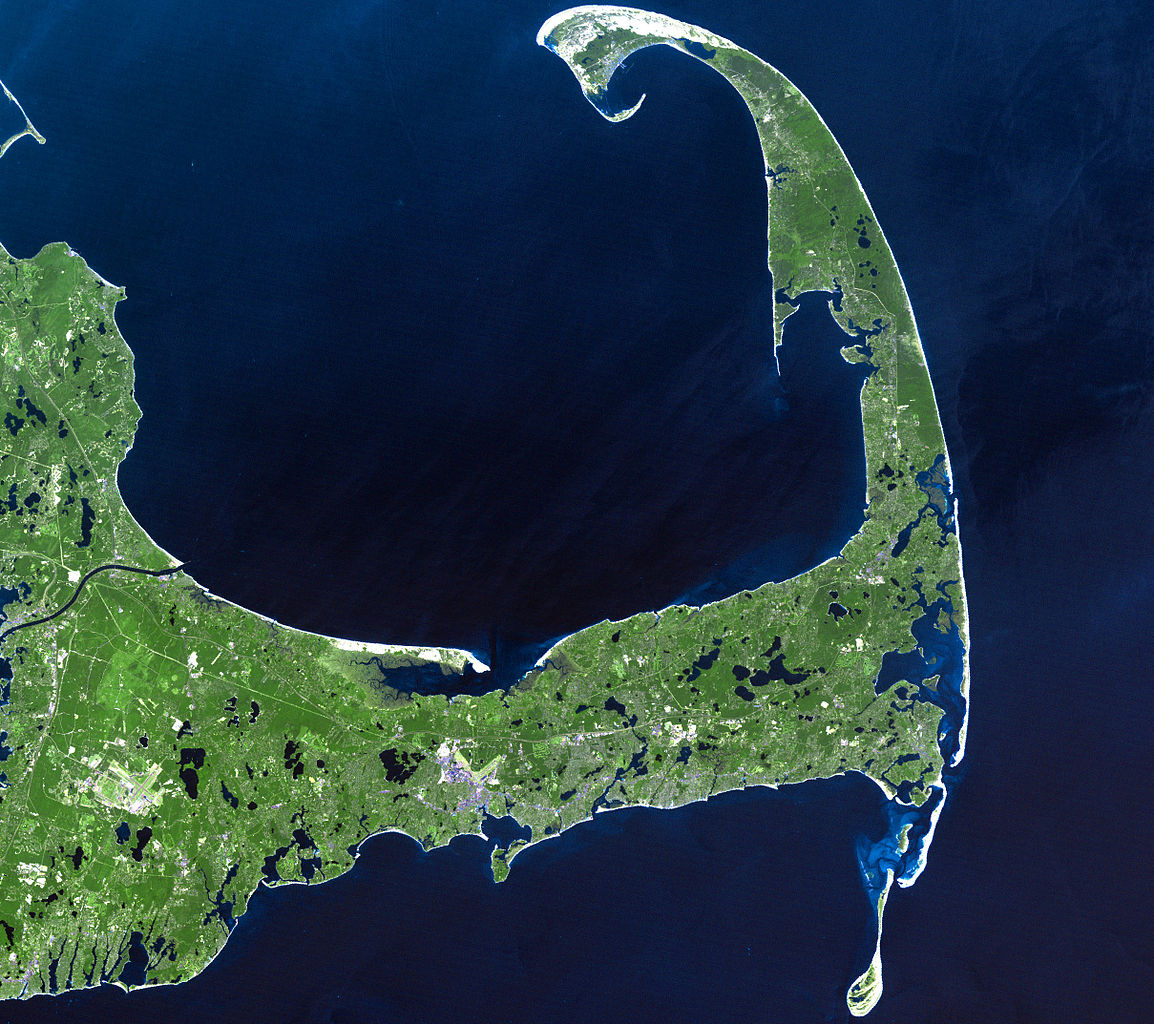
English: In easternmost Massachusetts, Cape Cod juts dramatically out into the Atlantic Ocean. The 65-mile peninsula has Cape Cod Bay to its north, the Nantucket Sound to its south and the Atlantic Ocean to its east. It is the world’s largest glacially formed peninsula; a remnant landscape left by the retreating Laurentide Ice Sheet.
The outer shore of the cape, from Long Point to south of Pleasant Bay, was designated as the Cape Cod National Seashore in August of 1961. The National Seashore encompasses over 44,000 acres of land, which includes marine, estuarine, and freshwater ecosystems. This Landsat 7 image was acquired on June 22, 2002. The pseudo-natural colour image, is a composite of ETM+ bands 7, 5, and 3. Cape Cod is found on Landsat WRS-2 Path 11 Row 31. |
| תאריך יצירה |
22 ביוני 2002 |
| מקור |
http://landsat.gsfc.nasa.gov/images/lg_jpg/f0006_06.22.02.jpg (http://landsat.gsfc.nasa.gov/images/archive/f0006.html) |
| יוצר |
NASA/Landsat 7. Original uploader was Ktr101 at en.wikipedia |
רישיון
| קובץ זה נמצא ברשות הציבור מכיוון שהוא נוצר על ידי נאס"א. מדיניות זכויות היוצרים של נאס"א קובעת ש"חומרים של NASA אינם מוגנים בזכויות יוצרים אלא אם צוין אחרת". (דף מדיניות זכויות היוצרים ב-NASA או מדיניות שימוש בתמונות ב-JPL). | ||
 |
אזהרות:
|
This image is in the public domain in the United States because it only contains materials that originally came from the United States Geological Survey, an agency of the United States Department of the Interior. For more information, see the official USGS copyright policy.
|
יומן העלאה מקורי
תיאור הקובץ המקורי נמצא כאן. כל שמות המשתמשים הבאים מתייחסים ל-en.wikipedia.
- 2008-06-14 02:08 Ktr101 2418×2145× (1120814 bytes) Cape Cod from a Landsat 7 image in 2002. Source:http://landsat.gsfc.nasa.gov/images/archive/f0006.html
היסטוריית הקובץ
ניתן ללחוץ על תאריך/שעה כדי לראות את הקובץ כפי שנראה באותו זמן.
| תאריך/שעה | תמונה ממוזערת | ממדים | משתמש | הערה | |
|---|---|---|---|---|---|
| נוכחית | 19:13, 9 באוגוסט 2009 | | 2,145 × 2,418 (1.07 מ"ב) | Transatracurium | {{Information |Description={{en| In easternmost Massachusetts, Cape Cod juts dramatically out into the Atlantic Ocean. The 65-mile peninsula has Cape Cod Bay to its north, the Nantucket Sound to its south and the Atlantic Ocean to its east. It is the worl |
שימוש בקובץ
הדף הבא משתמש בקובץ הזה:
שימוש גלובלי בקובץ
אתרי הוויקי השונים הבאים משתמשים בקובץ זה:
- שימוש באתר ca.wikipedia.org
- שימוש באתר de.wikipedia.org
- שימוש באתר en.wikipedia.org
- Cape Cod
- User:Dchurbuck
- User:Cape cod naturalist
- User:Clariosophic
- User:Seduisant
- User:Quissett
- Attack on Orleans
- User:Lrsears
- Wikipedia:WikiProject Cape Cod and the Islands
- Template:User WikiProject Cape Cod and the Islands
- User:Ktr101/Userboxes
- User:Grolltech
- User:Happyandrew1994
- Wikipedia:Userboxes/WikiProjects/Regional/03
- Shields (album)
- Wikipedia:Userboxes/WikiProjects/alphabetical/06
- Category:Wikipedians interested in Cape Cod and the Islands
- User:M V D H P
- שימוש באתר mk.wikipedia.org
- שימוש באתר sk.wikipedia.org
- שימוש באתר sr.wikipedia.org
- שימוש באתר www.wikidata.org