
קובץ:Anglo American War 1812 Locations map-en.svg

לקובץ המקורי (קובץ SVG, הגודל המקורי: 1,052 × 744 פיקסלים, גודל הקובץ: 136 ק"ב)
| זהו קובץ שמקורו במיזם ויקישיתוף. תיאורו בדף תיאור הקובץ המקורי (בעברית) מוצג למטה. |
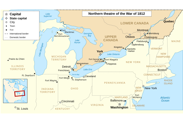
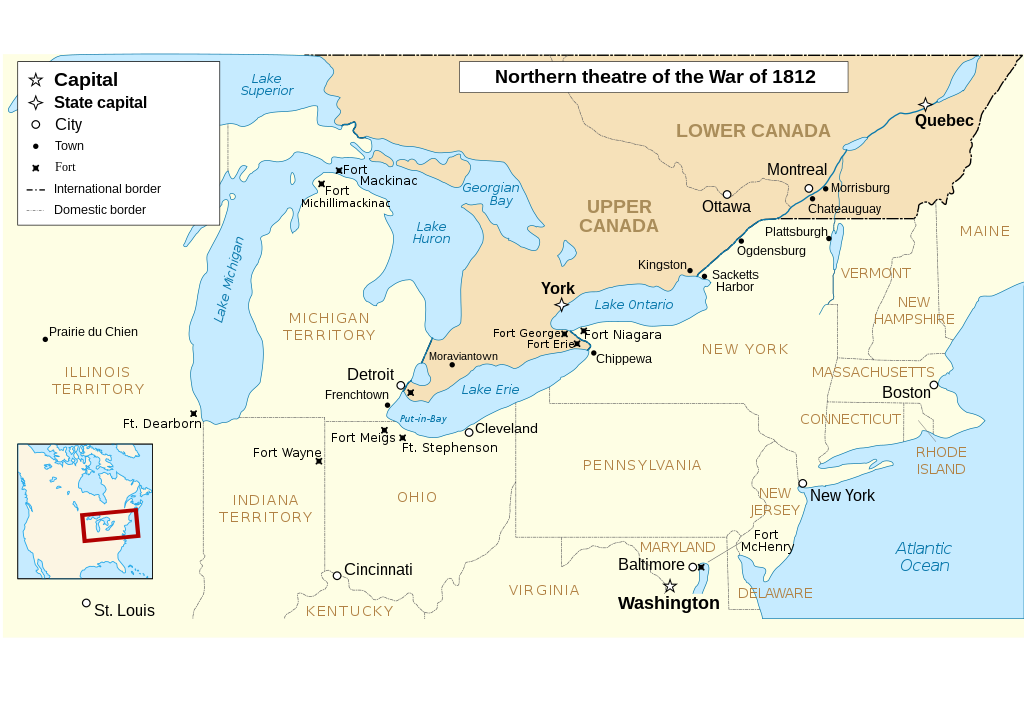
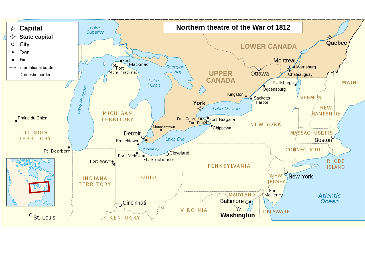
The map omits two of the most important battles of the war as far as the territorial outcome of the Treaty of Ghent. The Battle of Lake Erie (aka Battle of Put in Bay) was where the entire British Upper Great Lakes Fleet surrendered. With the Great Lakes supply lines cut, the British and their Indian allies destroyed the forts at Detroit and Amherstburg and tried to retreat up the Thames River hoping to reach the main British base at Burlington on Lake Ontario.The American army under General Harrison caught up with them at Moraviantown and the British were defeated. Most important was that Tecumseh was killed at this battle and, with his death, the Indian Confederation fell apart and thousands of the warriors just went home. When the Duke of Wellington, fresh from defeating Napoleon, was subsequently offered command of the British Army in America, he said he'd go but couldn't promise anything unless the Navy first got control of the Great Lakes. Otherwise, he told the negotiators that they may as well give up on any territorial demands and just make peace with the US. See "Three Strikes in the War of 1812".
| תיאור |
English: Main locations of the War of 1812 between the United States and the United Kingdom Français : Principaux théâtres d'opérations de la Guerre de 1812 entre les États-Unis et le Royaume-Uni. Español: Principales teatros de operaciones de la Guerra de 1812 entre los Estados Unidos y el Reino Unido. |
| תאריך יצירה | (UTC) |
| מקור | |
| יוצר |
|
| גרסאות אחרות |
Derivative works of this file: |
| זוהי תמונה מרוטשת, זאת אומרת שהתמונה שונתה בצורה דיגיטלית מהמקור. Modifications: translated to english. את התמונה המקורית ניתן לראות ב: Anglo American War 1812 Locations map-fr.svg. השינוי בוצע על ידי P. S. Burton.
|
- הנכם רשאים:
- לשתף – להעתיק, להפיץ ולהעביר את העבודה
- לערבב בין עבודות – להתאים את העבודה
- תחת התנאים הבאים:
- ייחוס – יש לתת ייחוס הולם, לתת קישור לרישיון, ולציין אם נעשו שינויים. אפשר לעשות את זה בכל צורה סבירה, אבל לא בשום צורה שמשתמע ממנה שמעניק הרישיון תומך בך או בשימוש שלך.
- שיתוף זהה – אם תיצרו רמיקס, תשנו, או תבנו על החומר, חובה עליכם להפיץ את התרומות שלך לפי תנאי רישיון זהה או תואם למקור.

|
מוענקת בכך הרשות להעתיק, להפיץ או לשנות את המסמך הזה, לפי תנאי הרישיון לשימוש חופשי במסמכים של גנו, גרסה 1.2 או כל גרסה מאוחרת יותר שתפורסם על־ידי המוסד לתוכנה חופשית; ללא פרקים קבועים, ללא טקסט עטיפה קדמית וללא טקסט עטיפה אחורית. עותק של הרישיון כלול בפרק שכותרתו הרישיון לשימוש חופשי במסמכים של גנו. |
יומן העלאה מקורי
This image is a derivative work of the following images:
- File:Anglo_American_War_1812_Locations_map-fr.svg licensed with Cc-by-sa-3.0,2.5,2.0,1.0, GFDL
- 2008-06-20T23:26:18Z MaCRoEco 1494x830 (154198 Bytes) {{Information |Description= |Source= |Date= |Author= |Permission= |other_versions= }}
- 2008-06-17T16:04:43Z Sémhur 1494x830 (163461 Bytes) Mistake : Fort Henry => Fort McHenry
- 2008-06-17T09:50:41Z Sémhur 1494x830 (163245 Bytes) {{Information |Description={{en|1=Main locations of the [[:en:War of 1812|War of 1812]] between the United States and the United Kingdom}} {{fr|1=Principaux théâtres d'opérations de la [[:fr:Guerre de 1812|Guerre de 1812]]
Uploaded with derivativeFX
היסטוריית הקובץ
ניתן ללחוץ על תאריך/שעה כדי לראות את הקובץ כפי שנראה באותו זמן.
| תאריך/שעה | תמונה ממוזערת | ממדים | משתמש | הערה | |
|---|---|---|---|---|---|
| נוכחית | 03:52, 6 במרץ 2023 | | 744 × 1,052 (136 ק"ב) | Hunter9502 | Reverted to version as of 08:55, 7 February 2021 (UTC) - February 2023 version has broken SVG formatting |
| 03:15, 4 בפברואר 2023 |  | 915 × 1,600 (493 ק"ב) | Yourlocallordandsavior | Removed useless sections. | |
| 11:55, 7 בפברואר 2021 |  | 744 × 1,052 (136 ק"ב) | Kevin1776 | Added requested missing locations (Moraviantown, Put-in-Bay), moved Fort Meigs to correct locations, other font & readability adjustments. | |
| 21:03, 25 ביולי 2011 |  | 830 × 1,494 (128 ק"ב) | Amirki | minor color change | |
| 00:05, 23 בינואר 2011 |  | 830 × 1,494 (153 ק"ב) | P. S. Burton | {{Information |Description={{en|1=Main locations of the War of 1812 between the United States and the United Kingdom}} {{fr|1=Principaux théâtres d'opérations de la Guerre de 1812 entre les États-Unis et le R |
שימוש בקובץ
הדפים הבאים משתמשים בקובץ הזה:
שימוש גלובלי בקובץ
אתרי הוויקי השונים הבאים משתמשים בקובץ זה:
- שימוש באתר af.wikipedia.org
- שימוש באתר de.wikipedia.org
- שימוש באתר en.wikipedia.org
- שימוש באתר gd.wikipedia.org
- שימוש באתר hr.wikipedia.org
- שימוש באתר ro.wikipedia.org
- שימוש באתר ru.wikipedia.org
- שימוש באתר sv.wikipedia.org
- שימוש באתר vi.wikipedia.org