
קובץ:Alexander-Empire 323bc.jpg

לקובץ המקורי (2,321 × 1,288 פיקסלים, גודל הקובץ: 933 ק"ב, סוג MIME: image/jpeg)
| זהו קובץ שמקורו במיזם ויקישיתוף. תיאורו בדף תיאור הקובץ המקורי (בעברית) מוצג למטה. |
תקציר

|
יש ליצור מחדש את התמונה historical map הזו באמצעות גרפיקה וקטורית כדוגמת קובץ SVG. לפעולה זו מספר יתרונות, כפי שניתן לקרוא (באנגלית) בדף Commons:Media for cleanup. אם ברשותכם קובץ SVG, אנא העלו אותו. לאחר מכן, החליפו תבנית זו בתבנית
{{vector version available|שם הקובץ.svg}} |


| תיאור |
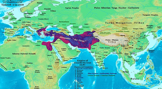
English: The Empire of Alexander the Great in 323 BC. |
| תאריך יצירה | |
| מקור | נוצר על־ידי מעלה היצירה See the source info for East-Hem 323bc.jpg |
| יוצר | Thomas Lessman (Contact!) |
| אישורים והיתרים (שימוש חוזר בקובץ זה) |
אני, בעל זכויות היוצרים על עבודה זו, מפרסם בזאת את העבודה תחת הרישיון הבא: הקובץ הזה מתפרסם לפי תנאי רישיון קריאייטיב קומונז ייחוס-שיתוף זהה 3.0 לא מותאם.
|
| גרסאות אחרות | see below |
Map Summary

Original Source URL: http://www.thomaslessman.com/History/images/East-Hem_001ad.jpg
This map is a zoomed-in version of Thomas Lessman's map of the
East-Hem_323bc.jpg (also available at www.WorldHistoryMaps.info).
The highlighted areas represent the Empire of Alexander the Great at his death in 323 BC.
Map Source References
- Remember, sources often conflict with each other. This map is only as accurate as the information that is available to me.
- To report any errors or to help further this work, please use the Corrections page, or email Thomas Lessman at talessman@yis.us
References for information contained in this map:
Empire of Alexander the Great information is derived from:
- The DK Atlas of World History, 2000 Edition; map of Alexander's Empire and successors; (Pg. 224)
- Wikimedia's map of The Empire of Alexander the Great uploaded by User talk:Captain Blood
- Wikipedia's article about Alexander the Great
I - European Information:
- Roman Republic borders are derived from The DK Atlas of World History, 2000 Edition; Pg. 178; Map of Italy in 240 BCE (also shows Roman borders in 300 BCE).
II - Asian Information:
- Chinese Area borders are derived from this map of The Contending States Boundries c. 350 BC, available on Huhai.net.
- Indian Kingdoms locations are derived from Wikimedia's map of Epic India.
- Gangaridai Note: the borders depicted for Gangaridai are not shown on any maps I've seen, they are described rather vaguely in the sources below:
- This article about The Origins of the Ganga Dynasty - A New Insight archive copy at the Wayback Machine by Dr. Harihar Kanungo; (Pg 25, section a).
- This article from Missouri Southern State University about Gangaridae in Megasthenes' Indica archive copy at the Wayback Machine; (Section 37).
- The History of Bengal website, which contains extensive information on an archeological site called Chandraketugarh, which may be the lost city of Ganga (the capital of Gangaridai).
- Nanda Dynasty borders are derived from:
- The DK Atlas of World History, 2000 Edition; Map of The Nanda and Mauryan Empires 365-181 BCE; (Pg. 241)
- Văn Lang borders are derived from:
- Wikimedia's map of Van Lang, created by User:Briangotts.
- Wikipedia's articles about Văn Lang and the Hồng Bàng Dynasty.
III - African Information and info for fringe areas like Africa, Australia, Siberia, etc. derive from:
- The DK Atlas of World History, 2000 Edition; map of The development of complex societies in Africa; (Page 160)
- Wikimedia's map of the World 323 BCE, created by User:Briangotts, and
- Wikimedia's map of the World in 300 BCE, created by User:Javierfv1212.
Note: Much of the information in this map was cross-checked with Bruce Gordon's Regnal Chronologies archive copy at the Wayback Machine.
Other Maps by Thomas Lessman
| Maps of the eastern hemisphere showing history
Bold dates are available on Wikimedia or Wikipedia. | ||
| Primeval | ||
| Ancient
|
·| 600 BC | 550 BC | 527 BC | 500 BC |
400 BC | ·| 1 AD | 50 AD | 100 AD | 200 AD | 300 AD | | |
| Medieval |
·| 500 AD | 565 AD | 600 AD | 700 AD | | |
| Modern |
·| 1500 AD | · * For historical maps of the whole world, | |
Other Info
רישיון
- הנכם רשאים:
- לשתף – להעתיק, להפיץ ולהעביר את העבודה
- לערבב בין עבודות – להתאים את העבודה
- תחת התנאים הבאים:
- ייחוס – יש לתת ייחוס הולם, לתת קישור לרישיון, ולציין אם נעשו שינויים. אפשר לעשות את זה בכל צורה סבירה, אבל לא בשום צורה שמשתמע ממנה שמעניק הרישיון תומך בך או בשימוש שלך.
- שיתוף זהה – אם תיצרו רמיקס, תשנו, או תבנו על החומר, חובה עליכם להפיץ את התרומות שלך לפי תנאי רישיון זהה או תואם למקור.
היסטוריית הקובץ
ניתן ללחוץ על תאריך/שעה כדי לראות את הקובץ כפי שנראה באותו זמן.
| תאריך/שעה | תמונה ממוזערת | ממדים | משתמש | הערה | |
|---|---|---|---|---|---|
| נוכחית | 17:02, 23 במאי 2008 | | 1,288 × 2,321 (933 ק"ב) | Talessman | |Author= Talessman Category:Alexander the Great Category:Hellenistic age Category:Maps of Hellenistic States |
שימוש בקובץ
הדף הבא משתמש בקובץ הזה:
שימוש גלובלי בקובץ
אתרי הוויקי השונים הבאים משתמשים בקובץ זה:
- שימוש באתר azb.wikipedia.org
- שימוש באתר bg.wikipedia.org
- שימוש באתר crh.wikipedia.org
- שימוש באתר de.wikipedia.org
- שימוש באתר en.wikipedia.org
- שימוש באתר en.wikibooks.org
- שימוש באתר es.wikipedia.org
- שימוש באתר gom.wikipedia.org
- שימוש באתר id.wikipedia.org
- שימוש באתר ka.wikipedia.org
- שימוש באתר ml.wikipedia.org
- שימוש באתר ms.wikipedia.org
- שימוש באתר nn.wikipedia.org
- שימוש באתר no.wikipedia.org
- שימוש באתר pt.wikipedia.org
- שימוש באתר ro.wikipedia.org
- שימוש באתר sr.wikipedia.org
- שימוש באתר sv.wikipedia.org
- שימוש באתר ta.wikipedia.org
- שימוש באתר te.wikipedia.org
- שימוש באתר vi.wikipedia.org