
קובץ:Weathered growth rings at Aztec Ruins National Monument.jpg

גודל התצוגה המקדימה הזאת: 800 × 525 פיקסלים. רזולוציות אחרות: 320 × 210 פיקסלים | 640 × 420 פיקסלים | 1,024 × 671 פיקסלים | 1,280 × 839 פיקסלים | 1,969 × 1,291 פיקסלים.
לקובץ המקורי (1,969 × 1,291 פיקסלים, גודל הקובץ: 3.93 מ"ב, סוג MIME: image/jpeg)
| זהו קובץ שמקורו במיזם ויקישיתוף. תיאורו בדף תיאור הקובץ המקורי (בעברית) מוצג למטה. |
תקציר
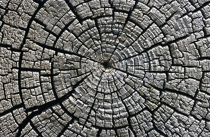
| תיאור |
Deutsch: Verwitterte Jahresringe an einem etwa im Jahr 1111 gefällten Baumstamm für den Bau des ersten Pueblo in dem Aztec Ruins National Monument, San Juan County, New Mexico, USA. Die Baumscheibe befindet sich in der Außenwand der heutigen West-Ruine.
English: Weathered growth rings in a horizontal cross section cut through an tree felled around AD 1111 used for the western building complex at Aztec Ruins National Monument, San Juan County, New Mexico, USA. There is the cross section cut of the tree located in the outer wall of the building.
Français : Cernes de croissance sur un tronc coupé en 1111 Ap-Jc. La date de l'abattage a pu être déterminée par Dendrochronologie en étudiant la largeur des cernes. Photo prise dans les bâtiments ouest (Eng.: western building complex) d'Aztec Ruins National Monument, dans le nouveau Mexique (États-Unis).
Italiano: La sezione trasversale di un tronco d'albero usato nel complesso occidentale del pueblo noto come Aztec Ruins National Monument, un sito archeologico (e dal 1987, anche Patrimonio dell'Umanità) del Nuovo Messico. Lo studio della sequenza di accrescimento degli anelli legnosi (visibili in foto) ha permesso di determinare l'anno di abbattimento della pianta (indicativamente, il 1111) e, conseguentemente, di datare la costruzione del complesso abitativo. |
| תאריך יצירה | |
| מקור | נוצר על־ידי מעלה היצירה |
| יוצר | Michael Gäbler |
|

תמונה זו נבחרה כתמונת היום בתאריך 12 במאי 2010. כותרתה: English: Weathered growth rings in a horizontal cross section cut through a tree felled around AD 1111 used for the western building complex at Aztec Ruins National Monument, San Juan County, New Mexico, USA. There is the cross section cut of the tree located in the outer wall of the building. שפות אחרות:
Čeština: Stářím poškozené letokruhy v řezu stromem, který byl pokácen kolem roku 1111, v Aztec Ruins National Monument v Novém Mexiku (USA) Dansk: Årringe i et tværsnit fra et træ fældet omkring år 1111 anvendt til opførelsen af en pueblo-bygning i Aztec-ruinerne Nationalmonument i New Mexico, USA. Deutsch: Verwitterte Jahresringe an einem etwa im Jahr 1111 für den Bau des ersten Pueblo in dem Aztec Ruins National Monument gefällten Baumstamm English: Weathered growth rings in a horizontal cross section cut through a tree felled around AD 1111 used for the western building complex at Aztec Ruins National Monument, San Juan County, New Mexico, USA. There is the cross section cut of the tree located in the outer wall of the building. Español: Anillos de crecimiento erosionados en un corte transversal de un árbol caído sobre el año 1111 y empleado en el complejo de edificios oeste del Monumento Nacional de las Ruinas Aztecas, Condado de San Juan, Nuevo México, EE. UU. Italiano: La sezione trasversale di un tronco d'albero usato nel complesso occidentale del pueblo noto come Aztec Ruins National Monument, un sito archeologico (e dal 1987, anche Patrimonio dell'Umanità) del Nuovo Messico. Lo studio della sequenza di accrescimento degli anelli legnosi (visibili in foto) ha permesso di determinare l'anno di abbattimento della pianta (indicativamente, il 1111) e, conseguentemente, di datare la costruzione del complesso abitativo Magyar: Évgyűrűk egy fatörzsben, amelyet az új-mexikói Aztec Pueblo egyik építkezésén használtak a 12. század elején Nederlands: Verweerde Groeiringen van een boom die in het jaar 1111 werd gekapt en gebruikt werd voor de bouw van het westelijke gebouwencomplex binnen het Aztec Ruins National Monument in de Amerikaanse staat New Mexico. De benaming 'Azteekse ruïnes' verwijst naar de misvatting van 19e eeuwse Amerikaanse kolonisten dat de ruïnes daarvan afkomstig waren. In werkelijkheid gaat het om pueblo's (een soort nederzettingen) van de Pueblo (Anasazi). Polski: Przekój przez słoje drzewa użytego do konstrukcji domów przez Indian z kultury Pueblo około 1111 r. n.e. Português: Anéis de crescimento de árvore do Aztec Ruins National Monument, Novo México, Estados Unidos da América. Svenska: Årsringar i ett kapat träd som fälldes runt år 1111 som användes i det västliga byggnadskomplexet i Aztec Ruins nationalmonument i San Juan County, New Mexico i USA. Беларуская (тарашкевіца): Узроставыя кольца ў распіле дрэва, зробленым прыблізна ў 1111 годзе. Ацтэкскія руіны. Македонски: Испукани годови на дрво пресечено околу 1111 г. употребено за изградба на западниот комплекс Ацтечки рушевини во Ново Мексико, САД Українська: Деревні кільця, які зазнали атмосферних впливів, на поперечному зрізі дерева, зрубаного приблизно 1111 року. Деревина вживалася для будівництва житла. Ацтекські руїни, Нью-Мексико, США. 한국어: 서기 1111년 경 베어져 풍화된 나무의 단면에 보이는 나이테. 미국 뉴멕시코 주 아즈텍유적 국립천연기념물 소재. 中文: 一棵约公元1111年被砍伐的树木的横切面,可以看到被风化的树木的年轮,该树用于建造美国新墨西哥州圣胡安县阿兹特克国家纪念碑西面建筑,切面位于建筑的外墙。 中文(繁體): 一棵約公元1111年被砍伐的樹木的橫切面,可以看到被風化的樹木的年輪,該樹用於建造美國新墨西哥州聖胡安縣阿茲特克國家紀念碑西面建築,切面位於建築的外牆。 |
| Camera Model | Olympus OM-1 |
|---|---|
| Scanner | Nikon Coolscan V ED |
| מיקום המצלמה | | תמונה זו ותמונות נוספות במיקום: OpenStreetMap |
|---|
רישיון
I, Michael Gäbler, בעל זכויות היוצרים על היצירה הזאת, מפרסם אותה בזאת תחת הרישיון הבא:
הקובץ הזה מתפרסם לפי תנאי רישיון קריאייטיב קומונז ייחוס 3.0 לא מותאם.
ייחוס: I, Michael Gäbler
- הנכם רשאים:
- לשתף – להעתיק, להפיץ ולהעביר את העבודה
- לערבב בין עבודות – להתאים את העבודה
- תחת התנאים הבאים:
- ייחוס – יש לתת ייחוס הולם, לתת קישור לרישיון, ולציין אם נעשו שינויים. אפשר לעשות את זה בכל צורה סבירה, אבל לא בשום צורה שמשתמע ממנה שמעניק הרישיון תומך בך או בשימוש שלך.
היסטוריית הקובץ
ניתן ללחוץ על תאריך/שעה כדי לראות את הקובץ כפי שנראה באותו זמן.
| תאריך/שעה | תמונה ממוזערת | ממדים | משתמש | הערה | |
|---|---|---|---|---|---|
| נוכחית | 03:57, 9 בינואר 2010 | | 1,291 × 1,969 (3.93 מ"ב) | Michael Gäbler | {{Information |Description={{en|1=Weathered growth rings in a horizontal cross section cut through an tree felled around AD 1111 used for the western building complex at [[:en:Aztec Ruins National Monument|Aztec Ruins |
שימוש בקובץ
הדפים הבאים משתמשים בקובץ הזה:
שימוש גלובלי בקובץ
אתרי הוויקי השונים הבאים משתמשים בקובץ זה:
- שימוש באתר ba.wikipedia.org
- שימוש באתר bn.wikipedia.org
- שימוש באתר crh.wikipedia.org
- שימוש באתר cv.wikipedia.org
- שימוש באתר de.wikipedia.org
- שימוש באתר en.wikipedia.org
- שימוש באתר fa.wikipedia.org
- שימוש באתר fr.wikipedia.org
- Parc national des grottes de Carlsbad
- El Malpais National Monument
- Aztec Ruins National Monument
- Capulin Volcano National Monument
- Gila Cliff Dwellings National Monument
- Bandelier National Monument
- El Morro National Monument
- Piste de Santa Fe
- Monument national de Petroglyph
- Camino Real de Tierra Adentro
- Fort Union National Monument
- Salinas Pueblo Missions National Monument
- Parc national des White Sands
- Modèle:Palette Unités du National Park System au Nouveau-Mexique
- Manhattan Project National Historical Park
- Valles Caldera National Preserve
- Pecos National Historical Park
- Chaco Culture National Historical Park
- Old Spanish National Historic Trail
- שימוש באתר hr.wikipedia.org
- שימוש באתר hu.wikipedia.org
- שימוש באתר ko.wikipedia.org
- שימוש באתר lbe.wikipedia.org
- שימוש באתר mk.wikipedia.org
- שימוש באתר mn.wikipedia.org
- שימוש באתר os.wikipedia.org
- שימוש באתר pam.wikipedia.org
- שימוש באתר pl.wikipedia.org
- שימוש באתר pt.wikipedia.org
- שימוש באתר pt.wikibooks.org
- שימוש באתר ru.wikipedia.org
- שימוש באתר ru.wikinews.org
- שימוש באתר sah.wikipedia.org
- שימוש באתר uk.wikipedia.org
- שימוש באתר vi.wikipedia.org
- שימוש באתר xal.wikipedia.org