
קובץ:WW2-Holocaust-Poland.PNG
גודל התצוגה המקדימה הזאת: 557 × 600 פיקסלים. רזולוציות אחרות: 223 × 240 פיקסלים | 446 × 480 פיקסלים | 713 × 768 פיקסלים | 951 × 1,024 פיקסלים | 2,007 × 2,161 פיקסלים.
לקובץ המקורי (2,007 × 2,161 פיקסלים, גודל הקובץ: 1.34 מ"ב, סוג MIME: image/png)
| זהו קובץ שמקורו במיזם ויקישיתוף. תיאורו בדף תיאור הקובץ המקורי (בעברית) מוצג למטה. |

|
יש ליצור מחדש את התמונה map הזו באמצעות גרפיקה וקטורית כדוגמת קובץ SVG. לפעולה זו מספר יתרונות, כפי שניתן לקרוא (באנגלית) בדף Commons:Media for cleanup. אם ברשותכם קובץ SVG, אנא העלו אותו. לאחר מכן, החליפו תבנית זו בתבנית
{{vector version available|שם הקובץ.svg}} |
תקציר
| תיאור |
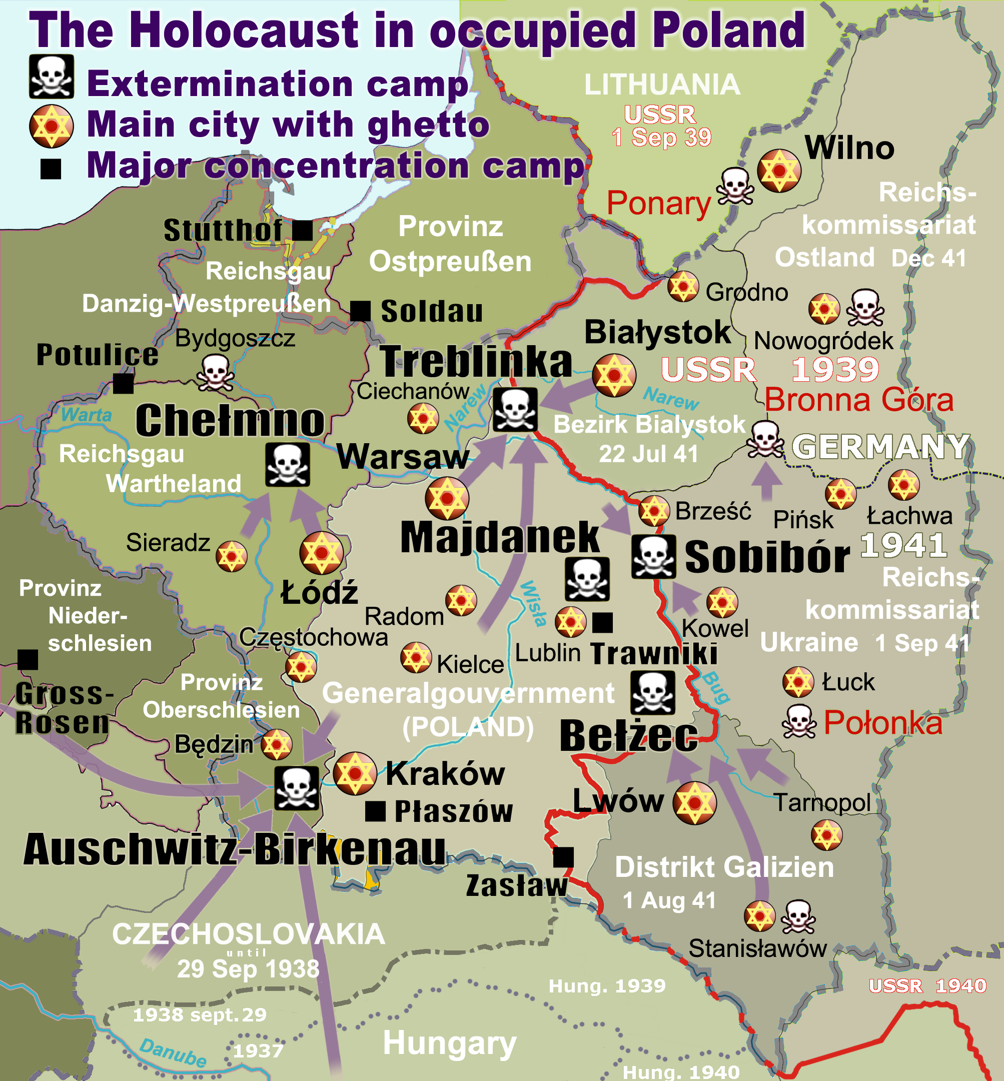
English: Map of the Holocaust in occupied Poland during World War II. The outline shows the borders of the Second Polish Republic at the time of the Nazi-German-and-Soviet invasion of Poland in 1939 with demarcation line between the two invading armies marked in red. Internal boundaries show the administrative divisions of occupied territories imposed by Nazi Germany when the Final Solution was set in motion during and after Operation Barbarossa of 1941. This map shows all Nazi German extermination camps (or death camps), as well as prominent concentration, labour and prison camps, major pre-WW2 Polish cities with the new Jewish ghettos set up by Nazi Germany, major deportation routes, and major massacre sites. Notes: 1. Extermination camps – marked with white skulls in black squares – are six dedicated facilities used for the mass gassings of prisoners, but all camps and ghettos took a toll of many, many lives. 2. Concentration camps – marked with black squares – feature only the most notorious forced-labor camps, prison camps & transit camps. 3. Sites of mass shootings into remote ravines – marked with white skulls – include Bronna Góra, Ponary and others. They were utilized during the 'Holocaust by bullets'. 4. Destruction ghettos – marked with Yellow stars in red circles – existed in most Polish cities. Only a selection is shown. 5. Major deportation routes travelled by the Holocaust trains are marked with RosyBrown arrows. 6. Most camps & ghettos which are not well known have been excluded for clarity. 7. District borders are at the height of Axis domination (1942). 8. Regions have German designations (e.g. "Ostland"), with the country name denoted in uppercase letters, e.g. LITHUANIA, CZECHOSLOVAKIA, or in parenthesis below the German occupational designation, e.g. (POLAND). |
| תאריך יצירה | |
| מקור |
נוצר על־ידי מעלה היצירה. Composite map derived from a variety of readily available sources which may or may not include:
|
| יוצר |
|
| אישורים והיתרים (שימוש חוזר בקובץ זה) |
PD, see below. The map is completely unrestricted for any Wikipedia/Wikimedia project. |
| גרסאות אחרות |
[]
|


.png)


.png)


רישיון
For all derivative works of maps uploaded earlier see below.
Poeticbent (en), בעל זכויות היוצרים על היצירה הזאת, מפרסם אותה בזאת תחת הרישיון הבא:
| ברצוני, בעלי זכויות היוצרים על יצירה זו, לשחרר יצירה זו לנחלת הכלל. זה תקף בכל העולם. יש מדינות שבהן הדבר אינו אפשרי על פי חוק, אם כך: אני מעניק לכל אחד את הזכות להשתמש בעבודה זו לכל מטרה שהיא, ללא תנאים כלשהם, אלא אם כן תנאים כאלה נדרשים על פי חוק. |
- File uploaded previously
Dennis Nilsson, בעל זכויות היוצרים על היצירה הזאת, מפרסם אותה בזאת תחת הרישיון הבא:
הקובץ הזה מתפרסם לפי תנאי רישיון קריאייטיב קומונז ייחוס 3.0 לא מותאם.
ייחוס: Dennis Nilsson
- הנכם רשאים:
- לשתף – להעתיק, להפיץ ולהעביר את העבודה
- לערבב בין עבודות – להתאים את העבודה
- תחת התנאים הבאים:
- ייחוס – יש לתת ייחוס הולם, לתת קישור לרישיון, ולציין אם נעשו שינויים. אפשר לעשות את זה בכל צורה סבירה, אבל לא בשום צורה שמשתמע ממנה שמעניק הרישיון תומך בך או בשימוש שלך.
Derivative work: Piotr Konieczny aka Prokonsul Piotrus Talk Derivative works of this file:
Derivative work: User:Poeticbent (Talk) Derivative works of this file:
- Uploaded previously
| זוהי תמונה מרוטשת, זאת אומרת שהתמונה שונתה בצורה דיגיטלית מהמקור. Modifications: Smaller version: occupied Poland only (pre-WWII borders). את התמונה המקורית ניתן לראות ב: WW2-Holocaust-Europe.png.
|
אני, בעל זכויות היוצרים על עבודה זו, מפרסם בזאת את העבודה תחת הרישיון הבא:
הקובץ הזה מתפרסם לפי תנאי רישיון קריאייטיב קומונז ייחוס 3.0 לא מותאם.
- הנכם רשאים:
- לשתף – להעתיק, להפיץ ולהעביר את העבודה
- לערבב בין עבודות – להתאים את העבודה
- תחת התנאים הבאים:
- ייחוס – יש לתת ייחוס הולם, לתת קישור לרישיון, ולציין אם נעשו שינויים. אפשר לעשות את זה בכל צורה סבירה, אבל לא בשום צורה שמשתמע ממנה שמעניק הרישיון תומך בך או בשימוש שלך.
יומן העלאה מקורי
For derivative works of the first uploaded file created by User:Dna-webmaster see the following:
- File:WW2-Holocaust-Europe.png licensed with Cc-by-3.0
Uploaded with derivativeFX
היסטוריית הקובץ
ניתן ללחוץ על תאריך/שעה כדי לראות את הקובץ כפי שנראה באותו זמן.
| תאריך/שעה | תמונה ממוזערת | ממדים | משתמש | הערה | |
|---|---|---|---|---|---|
| נוכחית | 18:46, 10 במרץ 2020 | | 2,161 × 2,007 (1.34 מ"ב) | Claude Zygiel | Cosmetics |
| 23:33, 28 במרץ 2018 |  | 2,161 × 2,007 (1.48 מ"ב) | Poeticbent | not an improvement: img looks muddy but I have original Photoshop layers, and can adjust them individually; comment on specifics in talk please | |
| 20:48, 27 במרץ 2018 |  | 2,161 × 2,007 (1.49 מ"ב) | Hohum | Too much information competing for attention in a very busy image. Toned down region name brightness, desaturated slightly. | |
| 08:38, 10 ביולי 2017 |  | 2,161 × 2,007 (1.48 מ"ב) | Poeticbent | vital updates following a discussion → prominent ghettos, legend | |
| 22:43, 25 ביולי 2015 |  | 2,161 × 2,007 (1.46 מ"ב) | Poeticbent | name of settlement: Górka Połonka, source Wolyn.ovh.org | |
| 21:27, 2 בדצמבר 2014 |  | 2,161 × 2,007 (1.46 מ"ב) | Poeticbent | added one missing marker | |
| 22:17, 7 במאי 2014 |  | 2,161 × 2,007 (1.45 מ"ב) | Poeticbent | location of Bronna Góra | |
| 20:34, 4 באפריל 2014 |  | 2,161 × 2,007 (1.44 מ"ב) | Poeticbent | Lachwa Ghetto location | |
| 00:31, 28 ביוני 2013 |  | 2,161 × 2,007 (1.42 מ"ב) | Poeticbent | major expansion with similar color-scheme | |
| 06:09, 28 ביוני 2011 |  | 339 × 364 (123 ק"ב) | LMK3 | changed the color of the Soviet Curzon line to indicate the two different occupation zones before Operation Barbarossa, refined the location of Warsaw |
שימוש בקובץ
הדפים הבאים משתמשים בקובץ הזה:
שימוש גלובלי בקובץ
אתרי הוויקי השונים הבאים משתמשים בקובץ זה:
- שימוש באתר ar.wikipedia.org
- שימוש באתר azb.wikipedia.org
- שימוש באתר az.wikipedia.org
- שימוש באתר bg.wikipedia.org
- שימוש באתר bn.wikipedia.org
- שימוש באתר br.wikipedia.org
- שימוש באתר ca.wikipedia.org
- שימוש באתר cs.wikipedia.org
- שימוש באתר cs.wikibooks.org
- שימוש באתר da.wikipedia.org
- שימוש באתר de.wikipedia.org
- שימוש באתר el.wikipedia.org
- Γκέτο της Τσενστοχόβα
- Γκέτο του Μπέντζιν
- Γκέτο του Μίζοτς
- Μπρόνα Γκούρα
- Γκέτο της Κρακοβίας
- Γκέτο του Μπζέσκο
- Στρατόπεδο συγκέντρωσης Τραβνίκι
- Στρατόπεδο συγκέντρωσης Ποτουλίτσε
- Γκέτο του Σοσνόβιετς
- Γκέτο του Ντροχόμπιτς
- Γκέτο του Ταρνόπολ
- Ιστορία των Εβραίων στην Πολωνία
- Γκέτο του Σιέντλτσε
- Γκέτο της Γουόμζα
- Γκέτο του Γκορλίτσε
- Γκέτο του Μπιαουίστοκ
- Γκέτο του Μπζεστς
- Γκέτο του Ράντομ
- Γκέτο του Νόβι Σοντς