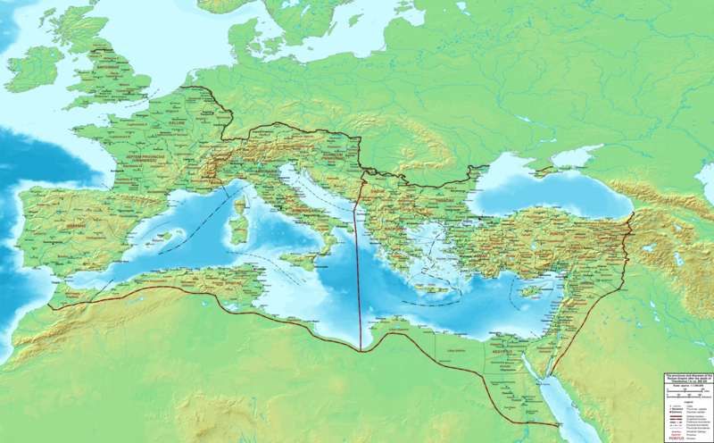
קובץ:The Roman Empire ca 400 AD.png

גודל התצוגה המקדימה הזאת: 800 × 496 פיקסלים. רזולוציות אחרות: 320 × 198 פיקסלים | 640 × 397 פיקסלים | 1,024 × 635 פיקסלים | 1,280 × 793 פיקסלים | 2,560 × 1,587 פיקסלים | 4,339 × 2,689 פיקסלים.
לקובץ המקורי (4,339 × 2,689 פיקסלים, גודל הקובץ: 12.8 מ"ב, סוג MIME: image/png)
היסטוריית הקובץ
ניתן ללחוץ על תאריך/שעה כדי לראות את הקובץ כפי שנראה באותו זמן.
| תאריך/שעה | תמונה ממוזערת | ממדים | משתמש | הערה | |
|---|---|---|---|---|---|
| נוכחית | 01:27, 20 בפברואר 2015 |  | 2,689 × 4,339 (12.8 מ"ב) | Cplakidas | added potential location of Valentia beyond Hadrian's Wall, removed provincial boundaries in Britannia as too tentative |
| 16:03, 21 ביולי 2011 |  | 2,689 × 4,339 (10.9 מ"ב) | Cplakidas | fixed Persian border, differentiated between Eastern and Western empire, different borders for praet. prefectures | |
| 05:37, 21 במרץ 2009 |  | 2,600 × 4,475 (9.99 מ"ב) | Cplakidas | minor corrections | |
| 15:30, 29 במאי 2008 |  | 2,370 × 3,800 (8.1 מ"ב) | Cplakidas | ||
| 15:17, 29 במאי 2008 |  | 2,850 × 4,560 (11.22 מ"ב) | Cplakidas | clearer version & addition of the Armenian satrapies | |
| 05:02, 30 בדצמבר 2007 |  | 2,120 × 3,380 (5.96 מ"ב) | Cplakidas | added names of dioceses, legend box, various minor adjustments | |
| 17:27, 13 בדצמבר 2007 |  | 2,200 × 3,550 (6.65 מ"ב) | Cplakidas | new improved version made with Inkscape, slight corrections in borders, added several cities in Africa & Spain | |
| 22:27, 12 בנובמבר 2007 |  | 2,200 × 3,550 (4.75 מ"ב) | Cplakidas | minor corrections in southern Gaul | |
| 15:58, 5 בנובמבר 2007 |  | 2,200 × 3,550 (4.75 מ"ב) | Cplakidas | New version, with some corrections & additions | |
| 19:55, 31 באוקטובר 2007 |  | 2,142 × 3,436 (4.5 מ"ב) | Cplakidas | {{Information |Description=Map of the Roman Empire ca. 400 AD, showing the administrative division into dioceses and provinces, as well as the major cities. The demarcation between Eastern and Western Empires is noted in red. |Source=Base map found at |
שימוש בקובץ
הדפים הבאים משתמשים בקובץ הזה:
שימוש גלובלי בקובץ
אתרי הוויקי השונים הבאים משתמשים בקובץ זה:
- שימוש באתר af.wikipedia.org
- שימוש באתר ar.wikipedia.org
- שימוש באתר ary.wikipedia.org
- שימוש באתר ast.wikipedia.org
- שימוש באתר bg.wikipedia.org
- שימוש באתר bn.wikipedia.org
- שימוש באתר ca.wikipedia.org
- שימוש באתר ceb.wikipedia.org
- שימוש באתר cs.wikipedia.org
- שימוש באתר de.wikipedia.org
- שימוש באתר el.wikipedia.org
- שימוש באתר en.wikipedia.org
- שימוש באתר eo.wikipedia.org
- שימוש באתר es.wikipedia.org
- שימוש באתר et.wikipedia.org
- שימוש באתר fr.wikipedia.org
- שימוש באתר hi.wikipedia.org
- שימוש באתר hr.wikipedia.org
- שימוש באתר hu.wikipedia.org
- שימוש באתר id.wikipedia.org
- שימוש באתר it.wikipedia.org
- שימוש באתר ko.wikipedia.org
- שימוש באתר la.wikipedia.org
- שימוש באתר lt.wikipedia.org
- שימוש באתר nl.wikipedia.org
- שימוש באתר no.wikipedia.org


