
קובץ:Superpower map 1945.png

גודל התצוגה המקדימה הזאת: 800 × 351 פיקסלים. רזולוציות אחרות: 320 × 140 פיקסלים | 640 × 281 פיקסלים | 1,425 × 625 פיקסלים.
לקובץ המקורי (1,425 × 625 פיקסלים, גודל הקובץ: 23 ק"ב, סוג MIME: image/png)
| זהו קובץ שמקורו במיזם ויקישיתוף. תיאורו בדף תיאור הקובץ המקורי (בעברית) מוצג למטה. |
Legend

|
יש ליצור מחדש את התמונה map הזו באמצעות גרפיקה וקטורית כדוגמת קובץ SVG. לפעולה זו מספר יתרונות, כפי שניתן לקרוא (באנגלית) בדף Commons:Media for cleanup. אם ברשותכם קובץ SVG, אנא העלו אותו. לאחר מכן, החליפו תבנית זו בתבנית
{{vector version available|שם הקובץ.svg}} |
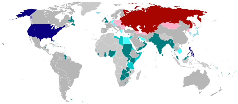
English:
English (en): Map of the world in 1945 with dependencies in lighter shading and respective superpowers at the time.
British Trust Territories
British Postwar Occupations
US postwar Occupations
Soviet postwar Occupations
বাংলা :
বাংলা (bn): ১৯৪৫ সালের মানচিত্রে পরাশক্তি ও তাদের উপর নির্ভর রাষ্ট্রসমূহ
ব্রিটিশ সাম্রাজ্য
ব্রিটিশদের বিশ্বস্ত অঞ্চলসমূহ
যুক্তরাষ্ট্র
যুক্তরাষ্ট্র বিশ্বস্ত অঞ্চলসমুহ
সোভিয়েত ইউনিয়ন
| היצירה הזאת שוחררה לנחלת הכלל על־ידי היוצר שלה, projectname מוויקיפדיה האנגלית. זה תקף בכל העולם. יש מדינות שבהן הדבר אינו אפשרי על פי חוק, אם כך: projectname מעניק לכל אחד את הזכות להשתמש ביצירה הזאת לכל מטרה, ללא שום תנאי, אלא אם כן תנאים כאלה נדרשים לפי החוק. |
.
היסטוריית הקובץ
ניתן ללחוץ על תאריך/שעה כדי לראות את הקובץ כפי שנראה באותו זמן.
| תאריך/שעה | תמונה ממוזערת | ממדים | משתמש | הערה | |
|---|---|---|---|---|---|
| נוכחית | 04:25, 19 באוקטובר 2020 | | 625 × 1,425 (23 ק"ב) | RickoTroanman22 | Fixed Hong Kong, also Tibet did not claim Inner Tibet. |
| 01:22, 7 בינואר 2019 |  | 625 × 1,425 (39 ק"ב) | BMacZero | colored most Aleutian Islands as United States | |
| 17:41, 2 ביולי 2017 |  | 625 × 1,425 (39 ק"ב) | Fireinacrowdedtheatre | Changed New Zealand to grey; the majority-white Dominions were not under British control by 1945 (except Newfoundland). Also added Soviet occupation of central Europe and Mongolia, British occupation of Greece, American occupation of Iceland, and the B... | |
| 02:11, 8 באוקטובר 2014 |  | 625 × 1,425 (43 ק"ב) | ZaidRock11 | Added post-World War II occupations in 1945 (Germany, Austria, Korea, Japan, Kwantung, Indochina); New Zealand did get full independence until 1947. | |
| 10:41, 9 ביוני 2013 |  | 625 × 1,425 (36 ק"ב) | Elmor | Germany occupation zones+Saar | |
| 03:11, 10 בפברואר 2012 |  | 625 × 1,425 (51 ק"ב) | Quintucket | Reverted to version as of 17:28, 20 August 2011 I missed the addition of Trust territories | |
| 10:14, 28 בינואר 2012 |  | 628 × 1,357 (52 ק"ב) | Quintucket | Reverted to version as of 21:44, 27 June 2007 Like User:Swarm said, India and the Philippines were still colonies at the time. Belarus and Ukraine were both UN members, which doesn't mean we should show them as non-USSR | |
| 11:12, 1 בדצמבר 2011 |  | 625 × 1,425 (57 ק"ב) | 23prootie~commonswiki | The Philippines and India are United Nations members in 1945 with guaranteed independence. They don't count. | |
| 20:28, 20 באוגוסט 2011 |  | 625 × 1,425 (51 ק"ב) | Swarm | re-add Philippines, which did not gain independence until 1946. It was commonwealth status they gained in 1934, not independence. | |
| 03:29, 27 באוקטובר 2010 |  | 625 × 1,425 (51 ק"ב) | Vadac | Clearer version, the Philippines became independent in 1934, added Mandates and Trust Territories. |
שימוש בקובץ
הדף הבא משתמש בקובץ הזה:
שימוש גלובלי בקובץ
אתרי הוויקי השונים הבאים משתמשים בקובץ זה:
- שימוש באתר ar.wikipedia.org
- שימוש באתר ast.wikipedia.org
- שימוש באתר az.wikipedia.org
- שימוש באתר be.wikipedia.org
- שימוש באתר el.wikipedia.org
- שימוש באתר en.wikipedia.org
- שימוש באתר es.wikipedia.org
- שימוש באתר fa.wikipedia.org
- שימוש באתר fr.wikipedia.org
- שימוש באתר hy.wikipedia.org
- שימוש באתר id.wikipedia.org
- שימוש באתר ja.wikipedia.org
- שימוש באתר ko.wikipedia.org
- שימוש באתר lt.wikipedia.org
- שימוש באתר no.wikipedia.org
- שימוש באתר pl.wikipedia.org
- שימוש באתר pt.wikipedia.org
- שימוש באתר ru.wikipedia.org
- שימוש באתר sco.wikipedia.org
- שימוש באתר ta.wikipedia.org
- שימוש באתר th.wikipedia.org
- שימוש באתר uz.wikipedia.org
- שימוש באתר zh-yue.wikipedia.org
- שימוש באתר zh.wikipedia.org