
קובץ:Six Day War Territories.png
Six_Day_War_Territories.png (398 × 599 פיקסלים, גודל הקובץ: 53 ק"ב, סוג MIME: image/png)
| זהו קובץ שמקורו במיזם ויקישיתוף. תיאורו בדף תיאור הקובץ המקורי (בעברית) מוצג למטה. |
תקציר

|
קיימת תמונה חדשה תמונה זו בגרסה וקטורית בפורמט "SVG". יש להחליף את התמונה הנוכחית בתמונה החדשה.
File:Six Day War Territories.png → File:Six Day War Terrritories.svg
למידע נוסף אודות גרפיקה וקטורית, אנא קראו אודות המעבר של ויקישיתוף לתמונות בפורמט SVG. ראו גם מידע אודות התמידה של מדיה-ויקי בתמונות בפורמט SVG. |
 |
| תיאור |
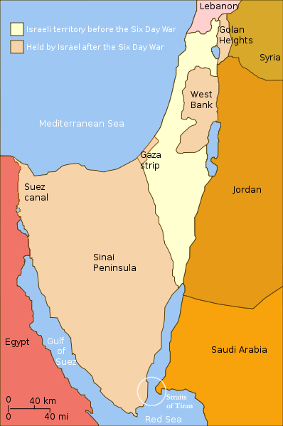
English: Changes in political boundaries following the Six Day war. In yellow: Israel within the "Green Line" borders (per 1949 ceasefire agreements); In light maroon: Territories Israel seized during the war and maintained its control over them in the aftermath of the war. The Straits of Tiran are circled, between the Gulf of Aqaba/Eilat, and the Red Sea. |
| תאריך יצירה | תאריך בלתי־ידוע |
| מקור | Yom Kippur War map.svg |
| יוצר | User:Ling.Nut |
| גרסאות אחרות |
[]
|


.png)


"Self-made line drawing of a map of Israel's territories before and after the Six Day War. Author: User:Ling.Nut Source of line drawing: File:Yom Kippur War map.svg authored by User:Raul654, sourced to now-deleted image Image:Jom kippur war.jpg, which was originally uploaded to the polish Wikipedia at http://pl.wikipedia.org/wiki/Grafika:Jom_kippur_war.jpg -- Ministerstwo Spraw Zagranicznych Izraela, za zgodÄ… Ambasady Izraela w Polsce. -- Ministry of Foreign Affairs of Israel, with the permission of Israel Embassy in Poland"
רישיון
- הנכם רשאים:
- לשתף – להעתיק, להפיץ ולהעביר את העבודה
- לערבב בין עבודות – להתאים את העבודה
- תחת התנאים הבאים:
- ייחוס – יש לתת ייחוס הולם, לתת קישור לרישיון, ולציין אם נעשו שינויים. אפשר לעשות את זה בכל צורה סבירה, אבל לא בשום צורה שמשתמע ממנה שמעניק הרישיון תומך בך או בשימוש שלך.
- שיתוף זהה – אם תיצרו רמיקס, תשנו, או תבנו על החומר, חובה עליכם להפיץ את התרומות שלך לפי תנאי רישיון זהה או תואם למקור.
היסטוריית הקובץ
ניתן ללחוץ על תאריך/שעה כדי לראות את הקובץ כפי שנראה באותו זמן.
| תאריך/שעה | תמונה ממוזערת | ממדים | משתמש | הערה | |
|---|---|---|---|---|---|
| נוכחית | 00:32, 12 בנובמבר 2010 | | 599 × 398 (53 ק"ב) | 99of9 | Reverted to version as of 07:04, 25 July 2010. Both POV versions should be at different locations, marked with POV and linked. |
| 14:06, 8 בנובמבר 2010 |  | 599 × 398 (52 ק"ב) | Supreme Deliciousness | Israeli territory before the Six day war is the same as after the Six day war. | |
| 10:04, 25 ביולי 2010 |  | 599 × 398 (53 ק"ב) | Ling.Nut | {{Information |Description={{en|1=Israeli territories before and after the Six Day War. The Straits of Tiran are circled, between the Gulf of Aqaba, and the Red Sea.}} |Source=Yom Kippur War map.svg |Author=User:Ling.Nut |Date= |Permission= |other_ver |
שימוש בקובץ
הדף הבא משתמש בקובץ הזה:
שימוש גלובלי בקובץ
אתרי הוויקי השונים הבאים משתמשים בקובץ זה:
- שימוש באתר ca.wikipedia.org
- שימוש באתר nl.wikipedia.org
- שימוש באתר ug.wikipedia.org
- שימוש באתר www.wikidata.org