
קובץ:Russian Occupation of Kherson Oblast.svg

לקובץ המקורי (קובץ SVG, הגודל המקורי: 1,430 × 1,048 פיקסלים, גודל הקובץ: 649 ק"ב)
| זהו קובץ שמקורו במיזם ויקישיתוף. תיאורו בדף תיאור הקובץ המקורי (בעברית) מוצג למטה. |
תקציר

|
This file may be updated to reflect new information. If you wish to use a specific version of the file without new updates being mirrored, please upload the required version as a separate file. |
| תיאור |
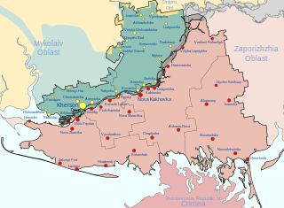
Русский: Заявленная ( , — деоккупированная) территория Херсонской военно-гражданской администрации, совпадающая с территорией Херсонской области Украины, и контролируемая ХВГА территория ( )
English: Claimed ( , — deoccupied) territory of Russia's Khersonskaya Oblast (not including the environs of Snihurivka), coinciding with the territory of Kherson Oblast in Ukraine, and dependent territory of Khersonskaya Oblast ( )
Français : territoire revendiqué ( , — déoccupé) de l'administration militaro-civile de Kherson, coïncidant avec le territoire de la région de Kherson en Ukraine, et territoire dépendant du AMCK ( ) |
| תאריך יצירה | 27 באוגוסט 2022 (first version) |
| מקור |
נוצר על־ידי מעלה היצירה, derivate of 2022 Russian invasion of Ukraine.svg by Viewsridge, Kherson in Ukraine (claims hatched).svg by TUBS, & Kherson military–civilian administration.png by Тыченко
|
| יוצר | Physeters |
| גרסאות אחרות |
[]
|


.png)


.png)


.svg)
This file is translated using SVG For most Wikipedia projects, you can embed the file normally (without a To translate the text into your language, you can use the SVG Translate tool. Alternatively, you can download the file to your computer, add your translations using whatever software you're familiar with, and re-upload it with the same name. You will find help in Graphics Lab if you're not sure how to do this. |
רישיון
- הנכם רשאים:
- לשתף – להעתיק, להפיץ ולהעביר את העבודה
- לערבב בין עבודות – להתאים את העבודה
- תחת התנאים הבאים:
- ייחוס – יש לתת ייחוס הולם, לתת קישור לרישיון, ולציין אם נעשו שינויים. אפשר לעשות את זה בכל צורה סבירה, אבל לא בשום צורה שמשתמע ממנה שמעניק הרישיון תומך בך או בשימוש שלך.
- שיתוף זהה – אם תיצרו רמיקס, תשנו, או תבנו על החומר, חובה עליכם להפיץ את התרומות שלך לפי תנאי רישיון זהה או תואם למקור.
היסטוריית הקובץ
ניתן ללחוץ על תאריך/שעה כדי לראות את הקובץ כפי שנראה באותו זמן.
| תאריך/שעה | תמונה ממוזערת | ממדים | משתמש | הערה | |
|---|---|---|---|---|---|
| נוכחית | 11:44, 16 בינואר 2024 | | 1,048 × 1,430 (649 ק"ב) | Physeters | remove Kakhovka Reservoir |
| 01:19, 16 בינואר 2024 |  | 1,048 × 1,430 (477 ק"ב) | Physeters | Updates per the ISW, add Bilohrudove, Pishchanivka, Kozachi Laheri and Krynky | |
| 08:57, 31 באוגוסט 2023 |  | 1,048 × 1,430 (464 ק"ב) | Physeters | the flooding completely subsided months ago | |
| 00:17, 2 ביולי 2023 |  | 1,048 × 1,430 (486 ק"ב) | Semyon 'dicto' Fedotov | fixed typo, removed unnecessary accents | |
| 09:52, 16 ביוני 2023 |  | 1,048 × 1,430 (486 ק"ב) | Physeters | update flooding and control of Oleshky per the ISW | |
| 00:13, 9 ביוני 2023 |  | 1,048 × 1,430 (478 ק"ב) | Physeters | Clean up flooded areas; make flooded areas grey, since they are most likely controlled by neither side at this time | |
| 21:52, 8 ביוני 2023 |  | 1,048 × 1,430 (469 ק"ב) | Nahabino | Update. | |
| 14:58, 8 ביוני 2023 |  | 1,048 × 1,430 (470 ק"ב) | Nahabino | Update. | |
| 17:07, 7 ביוני 2023 |  | 1,048 × 1,430 (470 ק"ב) | Nahabino | minor fixes | |
| 17:03, 7 ביוני 2023 |  | 1,048 × 1,430 (469 ק"ב) | Nahabino | Update with possible water flow. |
שימוש בקובץ
הדף הבא משתמש בקובץ הזה:
שימוש גלובלי בקובץ
אתרי הוויקי השונים הבאים משתמשים בקובץ זה:
- שימוש באתר ar.wikipedia.org
- שימוש באתר be.wikipedia.org
- שימוש באתר ca.wikipedia.org
- שימוש באתר cs.wikipedia.org
- שימוש באתר de.wikipedia.org
- שימוש באתר en.wikipedia.org
- שימוש באתר es.wikipedia.org
- שימוש באתר et.wikipedia.org
- שימוש באתר fr.wikipedia.org
- שימוש באתר hu.wikipedia.org
- שימוש באתר id.wikipedia.org
- שימוש באתר it.wikipedia.org
- שימוש באתר ja.wikipedia.org
- שימוש באתר lmo.wikipedia.org
- שימוש באתר lv.wikipedia.org
- שימוש באתר pl.wikipedia.org
- שימוש באתר pt.wikipedia.org
- שימוש באתר ru.wikipedia.org
- שימוש באתר uk.wikipedia.org
- שימוש באתר www.wikidata.org
- שימוש באתר zh.wikipedia.org