
קובץ:ProspectPark 1901Plan.jpg

לקובץ המקורי (4,017 × 2,536 פיקסלים, גודל הקובץ: 2.66 מ"ב, סוג MIME: image/jpeg)
| זהו קובץ שמקורו במיזם ויקישיתוף. תיאורו בדף תיאור הקובץ המקורי (בעברית) מוצג למטה. |
תקציר
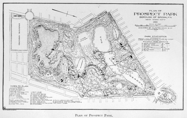
| תיאור | Plan of Prospect Park, Borough of Brooklyn, New York City |
| תאריך יצירה | |
| מקור | 1902 Annual Report, New York City Department of Parks |
| יוצר | City of New York |
| אישורים והיתרים (שימוש חוזר בקובץ זה) |
Published before 1923, Public Domain in the United States |
| גרסאות אחרות | Library of Congress: American Landscape and Architectural Design, 1850-1920, a lantern slide from the collection using the NYC Parks Department map as a source |
Remarks
This 1901 Plan map of Prospect Park, Brooklyn, NY was originally published in the 1902 Annual Report of the Department of Parks, City of New York. Map prepared by A. S. DeForest, Cartographer, for the George H. Walker & Company, Boston. There appear to be two errors in the map legend:
- 13, demarking 'East Wood Arch' (Meadowport Arch on the current (2006) map) appears to be located at the Thatched Hut (burned down 1937); the Thatched Hut is not indicated in the legend. The correct location of East wood (Meadowport) Arch is unmarked, but lies about 300 feet southwest of the misplaced marker; note where path appears to intersect/go under the West Drive.
- 28, demarking 'Administrative Buildings' appear to be where the greenhouses were located (demolished 1955).
Digital scan of the map furnished by Joy Holland, Research Librarian, Brooklyn Collection Brooklyn Public Library
רישיון
|
יצירה זו נמצאת בנחלת הכלל במדינת המקור ובמדינות אחרות בהם תקופת זכויות היוצרים היא משך חיי היוצר ו-70 שנה (או פחות) מפטירתו.
| |
| הקובץ הזה זוהה כקובץ חופשי מכל מגבלה ידועה תחת חוק זכויות היוצרים, כולל כל הזכויות הקשורות והסמוכות. | |
היסטוריית הקובץ
ניתן ללחוץ על תאריך/שעה כדי לראות את הקובץ כפי שנראה באותו זמן.
| תאריך/שעה | תמונה ממוזערת | ממדים | משתמש | הערה | |
|---|---|---|---|---|---|
| נוכחית | 21:48, 8 בספטמבר 2007 | | 2,536 × 4,017 (2.66 מ"ב) | Garry R. Osgood | This replacement file is an image scan at 300 dot/inch of the map as published in the 1902 Annual Report of the City of New York Department of Parks. Scan furnished by Joy Holland, Research Librarian, Brooklyn Collection w:Brooklyn Public Library |
| 21:40, 10 בינואר 2007 |  | 1,370 × 2,048 (737 ק"ב) | Garry R. Osgood | {{Information |Description= Plan of Prospect Park, Borough of Brooklyn, New York City |Source= 1902 Annual Report, New York City Department of Parks |Date= 1901 |Author= City of New York |Permission= Published before 1923, Public Domain in the United Sta |
שימוש בקובץ
הדף הבא משתמש בקובץ הזה:
שימוש גלובלי בקובץ
אתרי הוויקי השונים הבאים משתמשים בקובץ זה:
- שימוש באתר de.wikipedia.org
- שימוש באתר en.wikipedia.org
- שימוש באתר fr.wikipedia.org