
קובץ:Plan of St. Lucia, in the West Indies- Shewing the positions of the English and French forces with the attacks made at its reduction in Decr. 1778. LOC 74696150.jpg

גודל התצוגה המקדימה הזאת: 800 × 598 פיקסלים. רזולוציות אחרות: 320 × 239 פיקסלים | 640 × 479 פיקסלים | 1,024 × 766 פיקסלים | 1,280 × 957 פיקסלים | 2,560 × 1,915 פיקסלים | 3,107 × 2,324 פיקסלים.
לקובץ המקורי (3,107 × 2,324 פיקסלים, גודל הקובץ: 3.17 מ"ב, סוג MIME: image/jpeg)
| זהו קובץ שמקורו במיזם ויקישיתוף. תיאורו בדף תיאור הקובץ המקורי (בעברית) מוצג למטה. |
תקציר
| תיאור |
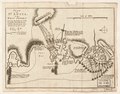
English: Scale ca. 1:51,000. Relief shown by hachures. Oriented with north to the left. Shows attacks made on Dec. 13-Dec. 16. Includes descriptive text. LC Maps of North America, 1750-1789, 2073 Available also through the Library of Congress Web site as a raster image. Vault AACR2: 651/1; 651/2 |
||
| Title | Plan of St. Lucia, in the West Indies: Shewing the positions of the English and French forces with the attacks made at its reduction in Decr. 1778. | ||
| Shelf ID | G5111.S2 1778 .B6 | ||
| תאריך יצירה | |||
| מקור | https://www.loc.gov/item/74696150/ | ||
| יוצר | Bowen, Thomas | ||
| אישורים והיתרים (שימוש חוזר בקובץ זה) |
|
||
| גרסאות אחרות |
|
||
| Location | Saint Lucia. · Saint Lucia | ||
| Part of | Military Battles And Campaigns · American Memory · Catalog · Geography And Map Division · American Revolution And Its Era: Maps And Charts Of North America And The West Indies, 1750-1789 | ||
| Subject | Saint Lucia, Battle Of, Saint Lucia · Maps · Early Works To 1800 · Saint Lucia · History |


רישיון
|
עבודת אמנות דו-מימדית זו המוצגת בתמונה שוחררה לרשות הציבור בכל העולם בעקבות תאריך מותו של היוצר, או תאריך פרסום היצירה. לפיכך, תצלום היצירה גם הוא ברשות הציבור.
הודעה זו תקפה לגבי התצלומים שנוצרו בארצות הברית, בגרמניה ובמדינות רבות נוספות.
| ||||
היסטוריית הקובץ
ניתן ללחוץ על תאריך/שעה כדי לראות את הקובץ כפי שנראה באותו זמן.
| תאריך/שעה | תמונה ממוזערת | ממדים | משתמש | הערה | |
|---|---|---|---|---|---|
| נוכחית | 23:47, 7 בינואר 2023 | | 2,324 × 3,107 (3.17 מ"ב) | PawełMM | Cropped 3 % horizontally, 7 % vertically using CropTool with lossless mode. The tatty edges removed. |
| 10:23, 6 בינואר 2023 |  | 2,495 × 3,190 (3.31 מ"ב) | PawełMM | cleaned, border removed | |
| 03:55, 16 בדצמבר 2018 |  | 2,584 × 3,296 (1.3 מ"ב) | Fæ | LOC Maps https://www.loc.gov/item/74696150/ #9214 |
שימוש בקובץ
הדף הבא משתמש בקובץ הזה:
שימוש גלובלי בקובץ
אתרי הוויקי השונים הבאים משתמשים בקובץ זה:
- שימוש באתר en.wikipedia.org
- שימוש באתר zh.wikipedia.org