
קובץ:Ottoman Empire Administrative Divisions.png
גודל התצוגה המקדימה הזאת: 552 × 600 פיקסלים. רזולוציות אחרות: 221 × 240 פיקסלים | 442 × 480 פיקסלים | 707 × 768 פיקסלים | 943 × 1,024 פיקסלים | 1,885 × 2,048 פיקסלים | 4,455 × 4,840 פיקסלים.
לקובץ המקורי (4,455 × 4,840 פיקסלים, גודל הקובץ: 2.1 מ"ב, סוג MIME: image/png)
| זהו קובץ שמקורו במיזם ויקישיתוף. תיאורו בדף תיאור הקובץ המקורי (בעברית) מוצג למטה. |
תקציר
| תיאור |
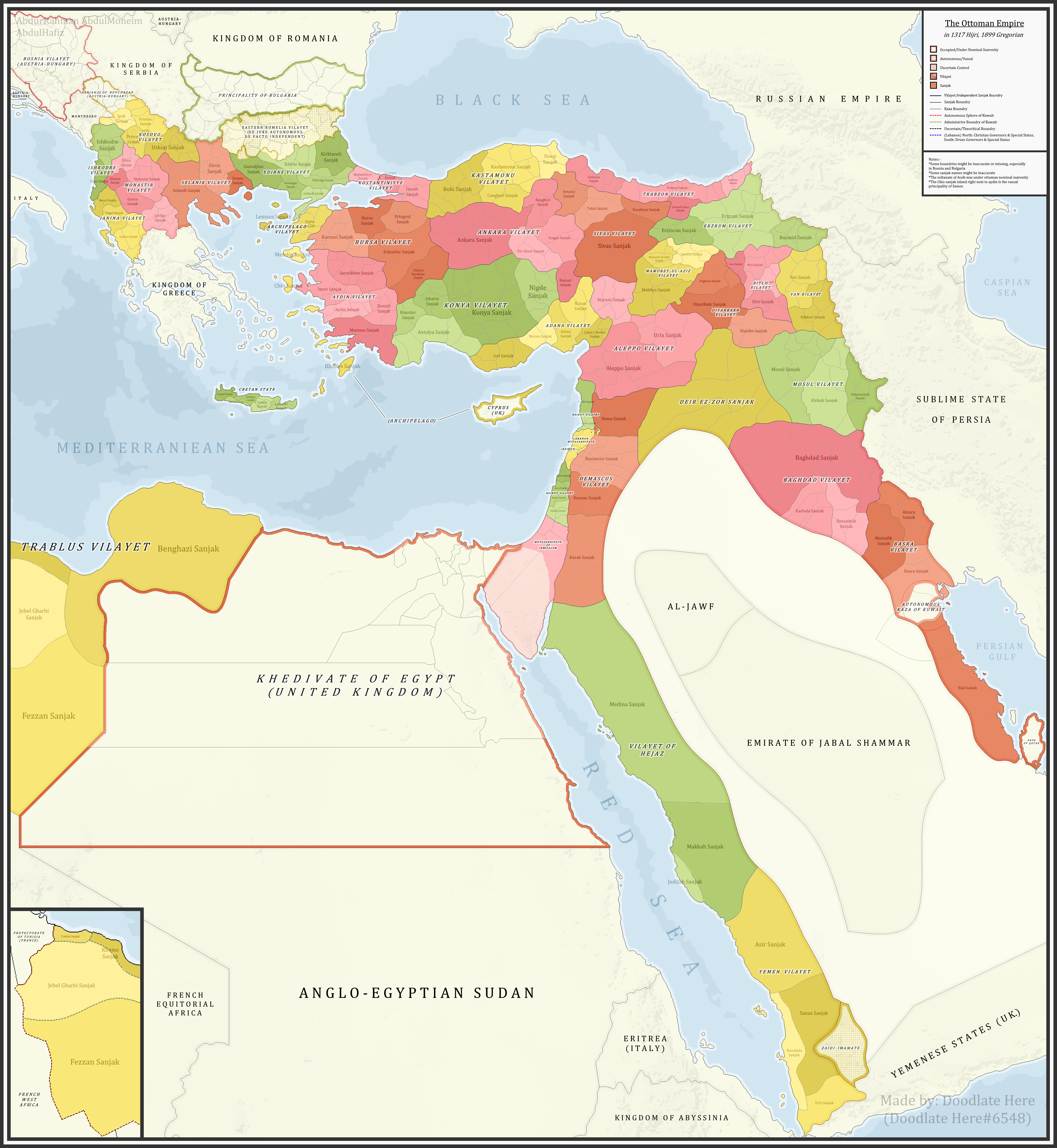
English: A detailed map showing the Ottoman Empire and its dependencies, including its administrative divisions, in 1899 CE (1317 Hijri). |
| תאריך יצירה | |
| מקור |
נוצר על־ידי מעלה היצירה References:The sources that back up the maps are as follows: [1] Pavet de Courteille, Abel (1876). État présent de l'empire ottoman (in French). J. Dumaine. pp. 91–96. (for Yemen) [2] http://tarihvemedeniyet.org/2009/10/trablus-garb-vilayeti.html for Tripolitania [3] http://tarihvemedeniyet.org/2009/10/bosna-vilayeti.html for Bosnia [4] https://www.nsi.bg/nrnm/index.php?i=1&ezik=en for eastern Rumelia [5] http://hdl.loc.gov/loc.gmd/g7431f.ct002181 (Rest of Ottoman subdivisions, taken from the United States Library of Congress's Geography & Map Division, digital ID g7431f.ct002181) |
| יוצר | AbdurRahman AbdulMoneim |
| גרסאות אחרות |

רישיון
אני, בעל זכויות היוצרים על עבודה זו, מפרסם בזאת את העבודה תחת הרישיון הבא:
הקובץ הזה מתפרסם לפי תנאי רישיון קריאייטיב קומונז ייחוס-שיתוף זהה 4.0 בין־לאומי.
- הנכם רשאים:
- לשתף – להעתיק, להפיץ ולהעביר את העבודה
- לערבב בין עבודות – להתאים את העבודה
- תחת התנאים הבאים:
- ייחוס – יש לתת ייחוס הולם, לתת קישור לרישיון, ולציין אם נעשו שינויים. אפשר לעשות את זה בכל צורה סבירה, אבל לא בשום צורה שמשתמע ממנה שמעניק הרישיון תומך בך או בשימוש שלך.
- שיתוף זהה – אם תיצרו רמיקס, תשנו, או תבנו על החומר, חובה עליכם להפיץ את התרומות שלך לפי תנאי רישיון זהה או תואם למקור.
| Annotations | This image is annotated: View the annotations at Commons |
היסטוריית הקובץ
ניתן ללחוץ על תאריך/שעה כדי לראות את הקובץ כפי שנראה באותו זמן.
| תאריך/שעה | תמונה ממוזערת | ממדים | משתמש | הערה | |
|---|---|---|---|---|---|
| נוכחית | 10:16, 16 בנובמבר 2021 | | 4,840 × 4,455 (2.1 מ"ב) | BasilLeaf | updates |
| 22:22, 5 במאי 2021 |  | 4,840 × 4,455 (2.11 מ"ב) | Super Dromaeosaurus | Romanian Black Sea Snake Island, Romanian-Russian border at Dobruja-Bessarabia, removed lands in Banat that didn't belong to Romania then | |
| 21:17, 14 באפריל 2021 |  | 4,840 × 4,455 (2.03 מ"ב) | محمد٢ | Reverted to version as of 18:40, 19 January 2021 (UTC) | |
| 05:05, 8 בפברואר 2021 |  | 4,840 × 4,455 (2.1 מ"ב) | BasilLeaf | Minor name fixes. Iran's official English name was "Sublime State of Persia". "Arab Gulf" Doesn't exist. There's "Arabian Gulf", a name that only came to decently widespread usage from 1960s. Contemporary internationally accepted term is "Persian Gulf". | |
| 21:40, 19 בינואר 2021 |  | 4,840 × 4,455 (2.03 מ"ב) | Userd898 | minor edit regarding the recoloring of a wrongly colored spot in haasa | |
| 21:05, 19 בינואר 2021 |  | 4,840 × 4,455 (2.03 מ"ב) | Userd898 | fixed some mistakes in yemen and labeled qatar as occupied source: https://www.euratlas.net/history/hisatlas/arabia/1904__AR.html | |
| 21:48, 14 בינואר 2021 |  | 4,840 × 4,455 (2.1 מ"ב) | BasilLeaf | Minor name fixes. Iran's official English name was "Sublime State of Persia". "Arab Gulf" Doesn't exist. There's "Arabian Gulf", a name that only came to decently widespread usage in 1960s. | |
| 22:15, 27 בדצמבר 2020 |  | 4,840 × 4,455 (2.03 מ"ב) | Userd898 | Uploaded own work with UploadWizard |
שימוש בקובץ
הדפים הבאים משתמשים בקובץ הזה:
שימוש גלובלי בקובץ
אתרי הוויקי השונים הבאים משתמשים בקובץ זה:
- שימוש באתר bg.wikipedia.org
- שימוש באתר bn.wikipedia.org
- שימוש באתר ca.wikipedia.org
- שימוש באתר ckb.wikipedia.org
- שימוש באתר de.wikipedia.org
- שימוש באתר el.wikipedia.org
- שימוש באתר en.wikipedia.org
- Ottoman Empire
- Sanjak
- Administrative divisions of the Ottoman Empire
- Kosovo vilayet
- Baghdad vilayet
- Mosul vilayet
- Scutari vilayet
- Basra vilayet
- Ottoman Tripolitania
- Ottoman Syria
- Abdul Hamid II
- Ottoman Iraq
- Mount Lebanon Mutasarrifate
- Janina vilayet
- Beirut vilayet
- Syria vilayet
- Hejaz vilayet
- Talk:Greater Palestine
- User:Falcaorib
- שימוש באתר es.wikipedia.org
- שימוש באתר fa.wikipedia.org
- שימוש באתר fi.wikipedia.org
- שימוש באתר fr.wikipedia.org
- שימוש באתר gl.wikipedia.org
- שימוש באתר it.wikipedia.org
- שימוש באתר ja.wikipedia.org
- שימוש באתר ku.wikipedia.org
- שימוש באתר lt.wikipedia.org
- שימוש באתר mk.wikipedia.org
- שימוש באתר mt.wikipedia.org
- שימוש באתר pt.wikipedia.org
- שימוש באתר ru.wikipedia.org