
קובץ:Old River Control Structure Complex.jpg

גודל התצוגה המקדימה הזאת: 750 × 600 פיקסלים. רזולוציות אחרות: 300 × 240 פיקסלים | 600 × 480 פיקסלים | 960 × 768 פיקסלים | 1,280 × 1,024 פיקסלים | 1,500 × 1,200 פיקסלים.
לקובץ המקורי (1,500 × 1,200 פיקסלים, גודל הקובץ: 1.02 מ"ב, סוג MIME: image/jpeg)
| זהו קובץ שמקורו במיזם ויקישיתוף. תיאורו בדף תיאור הקובץ המקורי (בעברית) מוצג למטה. |
| תיאור |
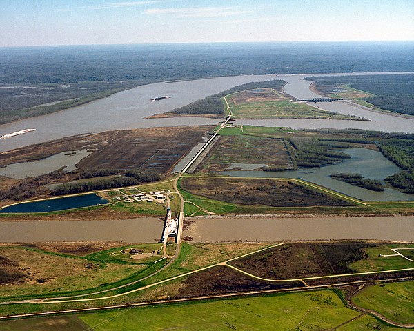
English: The Old River Control Structure at the juncture of the Mississippi River and the Atchafalaya River. In this photograph, the Mississippi River enters from the left and curves away to the right in the distance. The Atchafalaya River meets the Mississippi at three points and runs off to the bottom right. Control structures (dams) at each of the three forks of the Atchafalaya prevent most of the waters of the Mississippi from running into the Atchafalaya. The design of the structures is intended to keep 70% of the water in the Mississippi and 30% flowing into the Atchafalaya. View is to the east-southeast. The control structures are located at river mile 315 on the Mississippi (315 miles from the Gulf of Mexico). On the left of the river in this photograph is Wilkinson County in the State of Mississippi. Concordia Parish, Louisiana is on the right.
Français : La structure de régulation des eaux d'Old River, au défluent du Mississippi et de l'Atchafalaya. Sur cette photographie, le Mississippi coule depuis la gauche vers l'arrière-plan à droite. L'Atchafalaya part du Mississippi depuis trois points et coule vers l'avant-plan à droite. Les ouvrages de régulation (barrages) à chacune des branches de l'Atchafalaya empêchent la plupart des eaux du Mississippi de se déverser dans l'Atchafalaya. Ces structures sont conçues pour conserver 70% du débit dans le Mississippi et 30% dans l'Atchafalaya. La vue est vers l'est-sud-est. Les structures de régulation sont situées au point mile 315 à 506 km en amont de l'embouchure du Mississippi. Sur le côté gauche du Mississippi se trouve le comté de Wilkinson dans l'État du Mississippi. Sur le côté droit se trouve la paroisse de Concordia, en Louisiane. |
|||
| תאריך יצירה | ||||
| מקור |
U.S. Army Corps of Engineers Digital Visual Library Image page Image description page Digital Visual Library home page |
|||
| יוצר | Michael Maples, U.S. Army Corps of Engineers | |||
| אישורים והיתרים (שימוש חוזר בקובץ זה) |
|
|||
| מיקום | Wilkinson County, MIssissippi and Concordia County, Louisiana, USA |
| מיקום המצלמה | | תמונה זו ותמונות נוספות במיקום: OpenStreetMap |
|---|
היסטוריית הקובץ
ניתן ללחוץ על תאריך/שעה כדי לראות את הקובץ כפי שנראה באותו זמן.
| תאריך/שעה | תמונה ממוזערת | ממדים | משתמש | הערה | |
|---|---|---|---|---|---|
| נוכחית | 06:50, 6 באפריל 2007 | | 1,200 × 1,500 (1.02 מ"ב) | DanMS | {{Information | Description = {{en|The Old River Control Structure at the juncture of the Mississippi River and the Atchafalaya River. In this photograph, the Mississippi River runs along the left and curves away to the right in the distance. The Atcha |
שימוש בקובץ
הדף הבא משתמש בקובץ הזה:
שימוש גלובלי בקובץ
אתרי הוויקי השונים הבאים משתמשים בקובץ זה:
- שימוש באתר bg.wikipedia.org
- שימוש באתר de.wikipedia.org
- שימוש באתר en.wikipedia.org
- שימוש באתר fr.wikipedia.org
- שימוש באתר nl.wikipedia.org
- שימוש באתר www.wikidata.org