
קובץ:Oceanic pole of inaccessibility.png

גודל התצוגה המקדימה הזאת: 600 × 600 פיקסלים. רזולוציות אחרות: 240 × 240 פיקסלים | 480 × 480 פיקסלים | 960 × 960 פיקסלים.
לקובץ המקורי (960 × 960 פיקסלים, גודל הקובץ: 63 ק"ב, סוג MIME: image/png)
| זהו קובץ שמקורו במיזם ויקישיתוף. תיאורו בדף תיאור הקובץ המקורי (בעברית) מוצג למטה. |
תקציר

|
יש ליצור מחדש את התמונה map הזו באמצעות גרפיקה וקטורית כדוגמת קובץ SVG. לפעולה זו מספר יתרונות, כפי שניתן לקרוא (באנגלית) בדף Commons:Media for cleanup. אם ברשותכם קובץ SVG, אנא העלו אותו. לאחר מכן, החליפו תבנית זו בתבנית
{{vector version available|שם הקובץ.svg}} |
| תיאור |
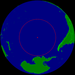
English: Spherical Earth centered on the oceanic pole of inaccessibility in the Southern Pacific ocean. The circle indicates the distance to the nearest landmasses (Antarctica, Easter Island and Ducie Island). The circle is deliberately a bit too small to ensure that the islands are still visible.
Deutsch: Erdkugel, zentriert auf dem ozeanischen Pol der Unzugänglichkeit im südlichen Pazifik. Der Kreis zeigt den Abstand zu den nächstgelegenen Landmassen (Antarktis, Osterinsel und Ducie). Der Kreis ist absichtlich ein wenig zu klein, damit die Inseln nicht verdeckt werden. |
| תאריך יצירה | |
| מקור | נוצר על־ידי מעלה היצירה |
| יוצר | Timwi |
| אישורים והיתרים (שימוש חוזר בקובץ זה) |
Public domain |
רישיון
| ברצוני, בעלי זכויות היוצרים על יצירה זו, לשחרר יצירה זו לנחלת הכלל. זה תקף בכל העולם. יש מדינות שבהן הדבר אינו אפשרי על פי חוק, אם כך: אני מעניק לכל אחד את הזכות להשתמש בעבודה זו לכל מטרה שהיא, ללא תנאים כלשהם, אלא אם כן תנאים כאלה נדרשים על פי חוק. |
היסטוריית הקובץ
ניתן ללחוץ על תאריך/שעה כדי לראות את הקובץ כפי שנראה באותו זמן.
| תאריך/שעה | תמונה ממוזערת | ממדים | משתמש | הערה | |
|---|---|---|---|---|---|
| נוכחית | 13:21, 24 במרץ 2015 | | 960 × 960 (63 ק"ב) | RokerHRO | optipng -o7 -i0 → 28.12% decrease |
| 02:40, 26 ביולי 2008 |  | 960 × 960 (88 ק"ב) | Timwi | {{Information |Description= |Source= |Date= |Author= |Permission= |other_versions= }} | |
| 02:14, 26 ביולי 2008 |  | 952 × 952 (38 ק"ב) | Timwi | {{Information |Description={{en|1=Spherical Earth centered on the oceanic en:pole of inaccessibility in the Southern Pacific ocean. The circle indicates the distance to the nearest landmasses (en:Antarctica, en:Easter Island and [[en:Ducie |
שימוש בקובץ
הדף הבא משתמש בקובץ הזה:
שימוש גלובלי בקובץ
אתרי הוויקי השונים הבאים משתמשים בקובץ זה:
- שימוש באתר ar.wikipedia.org
- שימוש באתר ast.wikipedia.org
- שימוש באתר az.wikipedia.org
- שימוש באתר ca.wikipedia.org
- שימוש באתר de.wikipedia.org
- שימוש באתר en.wikipedia.org
- שימוש באתר en.wikivoyage.org
- שימוש באתר es.wikipedia.org
- שימוש באתר et.wikipedia.org
- שימוש באתר eu.wikipedia.org
- שימוש באתר fa.wikipedia.org
- שימוש באתר frr.wikipedia.org
- שימוש באתר fr.wikipedia.org
- שימוש באתר fr.wiktionary.org
- שימוש באתר hu.wikipedia.org
- שימוש באתר id.wikipedia.org
- שימוש באתר it.wikipedia.org
- שימוש באתר ja.wikipedia.org
- שימוש באתר lb.wikipedia.org
- שימוש באתר lt.wikipedia.org
- שימוש באתר nl.wikipedia.org
- שימוש באתר nn.wikipedia.org
- שימוש באתר no.wikipedia.org
- שימוש באתר pl.wikipedia.org
- שימוש באתר pt.wikipedia.org
- שימוש באתר ro.wikipedia.org
- שימוש באתר sk.wikipedia.org
- שימוש באתר tr.wikipedia.org
- שימוש באתר uk.wikipedia.org
- שימוש באתר vi.wikipedia.org
- שימוש באתר www.wikidata.org
- שימוש באתר zh-classical.wikipedia.org