
קובץ:Nova totius terrarum orbis geographica ac hydrographica tabula (990027185480205171).jpg

גודל התצוגה המקדימה הזאת: 800 × 583 פיקסלים. רזולוציות אחרות: 320 × 233 פיקסלים | 640 × 467 פיקסלים | 1,024 × 747 פיקסלים | 1,280 × 934 פיקסלים | 2,560 × 1,867 פיקסלים | 9,163 × 6,683 פיקסלים.
לקובץ המקורי (9,163 × 6,683 פיקסלים, גודל הקובץ: 98.71 מ"ב, סוג MIME: image/jpeg)
| זהו קובץ שמקורו במיזם ויקישיתוף. תיאורו בדף תיאור הקובץ המקורי (בעברית) מוצג למטה. |
תקציר
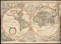
| Jodocus Hondius II: Nova Totius Terrarum Orbis Geographica ac Hydrographica Tabula
|
||||||||||||||||||||||||||||||||||||||||||||||||||||||||||||
|---|---|---|---|---|---|---|---|---|---|---|---|---|---|---|---|---|---|---|---|---|---|---|---|---|---|---|---|---|---|---|---|---|---|---|---|---|---|---|---|---|---|---|---|---|---|---|---|---|---|---|---|---|---|---|---|---|---|---|---|---|
| אומן |
|
.jpg) | ||||||||||||||||||||||||||||||||||||||||||||||||||||||||||
| כותרת |
לטינית: Nova Totius Terrarum Orbis Geographica ac Hydrographica Tabula Nova Totius Terrarum Orbis Geographica ac Hydrographica Tabula |
|||||||||||||||||||||||||||||||||||||||||||||||||||||||||||
| מפרסם | ||||||||||||||||||||||||||||||||||||||||||||||||||||||||||||
| סוג אובייקט |
antique map / מפה מאויירת ביד / מפת העולם / מפת העולם של שתי מחציות מעטפת הכדור / early world maps |
|||||||||||||||||||||||||||||||||||||||||||||||||||||||||||
| סוגה |
מפה |
|||||||||||||||||||||||||||||||||||||||||||||||||||||||||||
| תיאור |
Latina: Nova totius terrarum orbis geographica ac hydrographica tabula [cartographic material] / Auct Iud. Hondio.
English: The map is based on Hondius' World map of 1617. The map was the first to show Le Maire's Straits and the islands in the Pacific discovered by Le Maire and his explorations in New Guines. Hondius' map was also one of the earliest to show Hudson's Bay and the full course of th St. Lawrence in a curious configuration. |
|||||||||||||||||||||||||||||||||||||||||||||||||||||||||||
| שפה |
לטינית |
|||||||||||||||||||||||||||||||||||||||||||||||||||||||||||
| תאריך יצירה |
בסביבות |
|||||||||||||||||||||||||||||||||||||||||||||||||||||||||||
| תאריך הוצאה לאור |
בסביבות |
|||||||||||||||||||||||||||||||||||||||||||||||||||||||||||
| ממדים |
גובה: 39 ס"מ |
|||||||||||||||||||||||||||||||||||||||||||||||||||||||||||
| אוסף |
|
|||||||||||||||||||||||||||||||||||||||||||||||||||||||||||
| מיקום נוכחי |
|
|||||||||||||||||||||||||||||||||||||||||||||||||||||||||||
| מיקום הוצאה |
פריז |
|||||||||||||||||||||||||||||||||||||||||||||||||||||||||||
| הערות | ||||||||||||||||||||||||||||||||||||||||||||||||||||||||||||
| סימול ארכיון בספרייה הלאומית | W 14 | |||||||||||||||||||||||||||||||||||||||||||||||||||||||||||
| IE PID | IE13736752 | |||||||||||||||||||||||||||||||||||||||||||||||||||||||||||
| רוזטה שם קובץ | FL13746878 | |||||||||||||||||||||||||||||||||||||||||||||||||||||||||||
| מזהה רשומה בספרייה הלאומית (P3959) | 990027185480205171 | |||||||||||||||||||||||||||||||||||||||||||||||||||||||||||
| חיפוש בקטלוג מרחב | מפת העולם, Jodocus Hondius II, Michael van Lochom, לטינית, 1636, early world maps, antique map, מפה מאויירת ביד, מפת העולם של שתי מחציות מעטפת הכדור | |||||||||||||||||||||||||||||||||||||||||||||||||||||||||||
| קובץ זהויות | ||||||||||||||||||||||||||||||||||||||||||||||||||||||||||||
| מקור/צלם |
|
|||||||||||||||||||||||||||||||||||||||||||||||||||||||||||
| גרסאות אחרות | ||||||||||||||||||||||||||||||||||||||||||||||||||||||||||||
| Jpg / Tif version |
|
|||||||||||||||||||||||||||||||||||||||||||||||||||||||||||


_(cropped2).jpg)
_(cropped).jpg)
_(cropped).jpg)
_(cropped3).jpg)
_(cropped).jpg)
_(cropped4).jpg)
_(cropped5).jpg)
_(cropped6).jpg)
_(cropped7).jpg)
_(cropped9).jpg)
_(cropped10).jpg)
_(cropped11).jpg)
_(cropped12).jpg)
_(cropped8).jpg)

.jpg)
.jpg?uselang=he)
רישיון
|
יצירה זו נמצאת בנחלת הכלל במדינת המקור ובמדינות אחרות בהם תקופת זכויות היוצרים היא משך חיי היוצר ו-100 שנה (או פחות) מפטירתו.
This work is in the public domain in the United States because it was published (or registered with the U.S. Copyright Office) before January 1, 1929. | |
| הקובץ הזה זוהה כקובץ חופשי מכל מגבלה ידועה תחת חוק זכויות היוצרים, כולל כל הזכויות הקשורות והסמוכות. | |
היסטוריית הקובץ
ניתן ללחוץ על תאריך/שעה כדי לראות את הקובץ כפי שנראה באותו זמן.
| תאריך/שעה | תמונה ממוזערת | ממדים | משתמש | הערה | |
|---|---|---|---|---|---|
| נוכחית | 15:46, 25 באפריל 2023 | | 6,683 × 9,163 (98.71 מ"ב) | Geagea | c:User:Rillke/bigChunkedUpload.js: {{Artwork |artist = |author = |title = |description = {{la|1=Nova totius terrarum orbis geographica ac hydrographica tabula [cartographic material] / Auct Iud. Hondio.}} {{en|1=The map is based on Hondius' World map of 1617. The map was the first to show Le Maire's Straits and the islands in the Pacific discovered by Le Maire and his explorations in New Guines. Hondiu... |
שימוש בקובץ
הדף הבא משתמש בקובץ הזה:
שימוש גלובלי בקובץ
אתרי הוויקי השונים הבאים משתמשים בקובץ זה:
- שימוש באתר fr.wikipedia.org
- שימוש באתר www.wikidata.org
.jpg)