
קובץ:Mississippi-Coast-towns-NOAA.jpg
אין גרסה ברזולוציה גבוהה יותר.
Mississippi-Coast-towns-NOAA.jpg (750 × 382 פיקסלים, גודל הקובץ: 57 ק"ב, סוג MIME: image/jpeg)
| זהו קובץ שמקורו במיזם ויקישיתוף. תיאורו בדף תיאור הקובץ המקורי (בעברית) מוצג למטה. |

|
יש ליצור מחדש את התמונה map הזו באמצעות גרפיקה וקטורית כדוגמת קובץ SVG. לפעולה זו מספר יתרונות, כפי שניתן לקרוא (באנגלית) בדף Commons:Media for cleanup. אם ברשותכם קובץ SVG, אנא העלו אותו. לאחר מכן, החליפו תבנית זו בתבנית
{{vector version available|שם הקובץ.svg}} |


תקציר
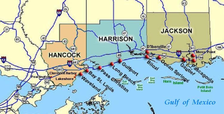
| תיאור | Coastal map of the U.S. state of Mississippi, showing major towns and cities in the three coastal counties: Hancock, Harrison, and Jackson County. Also shown are Cat Island, West Ship Island, East Ship Island, Horn Island and Petit Bois Island.The locations of towns, roads and offshore islands are based on NOAA and NASA maps. |
| תאריך יצירה | |
| מקור |
נוצר על־ידי מעלה היצירה; self-made (hand-edited with MS-Paint)
Pure stupidity: The map is in quick JPEG format, for large display as highly readable, in about 20 articles that display the map. JPEG clarity is enhanced by painted areas behind many labels, causing the wording to be clearer than even a massive SVG or PNG-format file could provide, due to the sharp display contrast of JPEG files. JPEG Clarity: Even though JPEG images have artifacts, they can display clearer wording in small maps due to auto-contrast enhancement. The same painted/shaded areas, that illuminate wording, would make the map excessively gargantuan in slow cumbersome PNG or SVG format, as is the case with terrain maps, which also should NEVER be converted to massive PNG format. |
| יוצר | Wikid77 |
רישיון
| היצירה הזאת שוחררה לנחלת הכלל על־ידי היוצר שלה, I, Wikid77. זה תקף בכל העולם. יש מדינות שבהן הדבר אינו אפשרי על פי חוק, אם כך: I, Wikid77 מעניק לכל אחד את הזכות להשתמש ביצירה הזאת לכל מטרה, ללא שום תנאי, אלא אם כן תנאים כאלה נדרשים לפי החוק. |
היסטוריית הקובץ
ניתן ללחוץ על תאריך/שעה כדי לראות את הקובץ כפי שנראה באותו זמן.
| תאריך/שעה | תמונה ממוזערת | ממדים | משתמש | הערה | |
|---|---|---|---|---|---|
| נוכחית | 05:54, 26 ביוני 2007 | | 382 × 750 (57 ק"ב) | Wikid77 | Brown-toned map: Hancock County as tan (was green); put "Gulf of Mexico" Antigua font; shift labels on islands |
| 03:17, 26 ביוני 2007 |  | 382 × 750 (56 ק"ב) | Wikid77 | Mississippi coastal map, with "Horn Island" relabeled, clarified Hwy "90" and "63" icons. | |
| 21:56, 21 ביוני 2007 |  | 382 × 750 (56 ק"ב) | Wikid77 | re-load of image file, in case internal data was garbled | |
| 21:11, 21 ביוני 2007 |  | 382 × 750 (56 ק"ב) | Wikid77 | {{Information |Description=Coastal map of the U.S. state of en:Mississippi, showing major towns and cities in the 3 coastal counties: Hancock, Harrison, a |
שימוש בקובץ
הדף הבא משתמש בקובץ הזה:
שימוש גלובלי בקובץ
אתרי הוויקי השונים הבאים משתמשים בקובץ זה:
- שימוש באתר ca.wikipedia.org
- שימוש באתר de.wikipedia.org
- שימוש באתר en.wikipedia.org
- Hancock County, Mississippi
- Pearlington, Mississippi
- Waveland, Mississippi
- Biloxi, Mississippi
- Gulfport, Mississippi
- Long Beach, Mississippi
- Gautier, Mississippi
- Ocean Springs, Mississippi
- Pascagoula Abduction
- Effects of Hurricane Katrina in Mississippi
- Ship Island
- Horn Island Chemical Warfare Service Quarantine Station
- שימוש באתר fr.wikipedia.org
- שימוש באתר fy.wikipedia.org
- שימוש באתר hu.wikipedia.org
- שימוש באתר it.wikipedia.org
- שימוש באתר ja.wikipedia.org
- שימוש באתר pt.wikipedia.org
- שימוש באתר tr.wikipedia.org
- שימוש באתר vi.wikipedia.org
- שימוש באתר zh.wikipedia.org