
קובץ:Max Simon, Karte des alttestamentlichen Palaestina (FL165906225 2366886).jpg

גודל התצוגה המקדימה הזאת: 800 × 534 פיקסלים. רזולוציות אחרות: 320 × 214 פיקסלים | 640 × 428 פיקסלים | 1,024 × 684 פיקסלים | 1,280 × 855 פיקסלים | 2,560 × 1,710 פיקסלים | 5,080 × 3,394 פיקסלים.
לקובץ המקורי (5,080 × 3,394 פיקסלים, גודל הקובץ: 14.03 מ"ב, סוג MIME: image/jpeg)
| זהו קובץ שמקורו במיזם ויקישיתוף. תיאורו בדף תיאור הקובץ המקורי (בעברית) מוצג למטה. |
תקציר
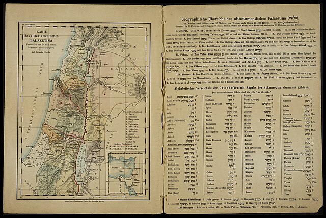
| Karte des alttestamentlichen Palaestina
|
|||||||||||||||||||||||||||||||||||||||||||
|---|---|---|---|---|---|---|---|---|---|---|---|---|---|---|---|---|---|---|---|---|---|---|---|---|---|---|---|---|---|---|---|---|---|---|---|---|---|---|---|---|---|---|---|
| אומן |
|
.jpg) | |||||||||||||||||||||||||||||||||||||||||
| כותרת |
Karte des alttestamentlichen Palaestina |
||||||||||||||||||||||||||||||||||||||||||
| מפרסם | |||||||||||||||||||||||||||||||||||||||||||
| סוג אובייקט |
מפה טופוגרפית |
||||||||||||||||||||||||||||||||||||||||||
| סוגה |
מפה |
||||||||||||||||||||||||||||||||||||||||||
| תיאור |
Karte des alttestamentlichen Palaestina. Entworfen von Dr. Max Simon, bearbeitet u.herausgegeben von Jul.Straube. |
||||||||||||||||||||||||||||||||||||||||||
| שפה |
גרמנית |
||||||||||||||||||||||||||||||||||||||||||
| תאריך הוצאה לאור |
1878 |
||||||||||||||||||||||||||||||||||||||||||
| ממדים |
גובה: 226 מ"מ |
||||||||||||||||||||||||||||||||||||||||||
| אוסף |
|
||||||||||||||||||||||||||||||||||||||||||
| מיקום נוכחי |
|
||||||||||||||||||||||||||||||||||||||||||
| מיקום הוצאה |
ברלין |
||||||||||||||||||||||||||||||||||||||||||
| הערות | Geograph. Institut; Incl. division among the 12 Tribes and later division of districts; Bottom right inset: Small map of eastern Mediterranean; On opposite page: Geographic notes on Palestine of the Old Testament and German-Hebrew alphabetical list of place names; Varies from first edition: Changes in index and modernized German spelling | ||||||||||||||||||||||||||||||||||||||||||
| IE PID | IE165906222 | ||||||||||||||||||||||||||||||||||||||||||
| רוזטה שם קובץ | FL165906225 | ||||||||||||||||||||||||||||||||||||||||||
| מזהה רשומה בספרייה הלאומית (P3959) | 990023668860205171 | ||||||||||||||||||||||||||||||||||||||||||
| חיפוש בקטלוג מרחב | גרמנית, מקס סימון, ברלין, Julius Straube, Geographisches Institut und Landkarten-Verlag Jul. Straube | ||||||||||||||||||||||||||||||||||||||||||
| חיפוש בקטלוג מרחב | Landkarten-Verlag Jul. Straube | ||||||||||||||||||||||||||||||||||||||||||
| מקור/צלם |
|
||||||||||||||||||||||||||||||||||||||||||
| גרסאות אחרות | |||||||||||||||||||||||||||||||||||||||||||
| Jpg / Tif version |
|
||||||||||||||||||||||||||||||||||||||||||


_(cropped).jpg)
_(cropped2).jpg)
_(cropped3).jpg)
_(cropped4).jpg)


.jpg)
.jpg?uselang=he)
רישיון
The copyright situation of this work is theoretically uncertain, because in the country of origin copyright lasts 70 years after the death of the author, and the date of the author's death is unknown. However, the date of creation of the work was over 120 years ago, and it is thus a reasonable assumption that the copyright has expired (see here for the community discussion). Do not use this template if the date of death of the author is known.
| |
| הקובץ הזה זוהה כקובץ חופשי מכל מגבלה ידועה תחת חוק זכויות היוצרים, כולל כל הזכויות הקשורות והסמוכות. | |
היסטוריית הקובץ
ניתן ללחוץ על תאריך/שעה כדי לראות את הקובץ כפי שנראה באותו זמן.
| תאריך/שעה | תמונה ממוזערת | ממדים | משתמש | הערה | |
|---|---|---|---|---|---|
| נוכחית | 16:11, 25 ביולי 2023 | | 3,394 × 5,080 (14.03 מ"ב) | Geagea | pattypan 22.03 |
שימוש בקובץ
הדף הבא משתמש בקובץ הזה:
שימוש גלובלי בקובץ
אתרי הוויקי השונים הבאים משתמשים בקובץ זה:
- שימוש באתר www.wikidata.org
.jpg)