
קובץ:Map of bronze-age tin finds. Objects in the eastern Mediterranean and the Near East, and major and minor tin deposits.png
לקובץ המקורי (3,521 × 2,300 פיקסלים, גודל הקובץ: 9.01 מ"ב, סוג MIME: image/png)
| זהו קובץ שמקורו במיזם ויקישיתוף. תיאורו בדף תיאור הקובץ המקורי (בעברית) מוצג למטה. |
תקציר
| תיאור |
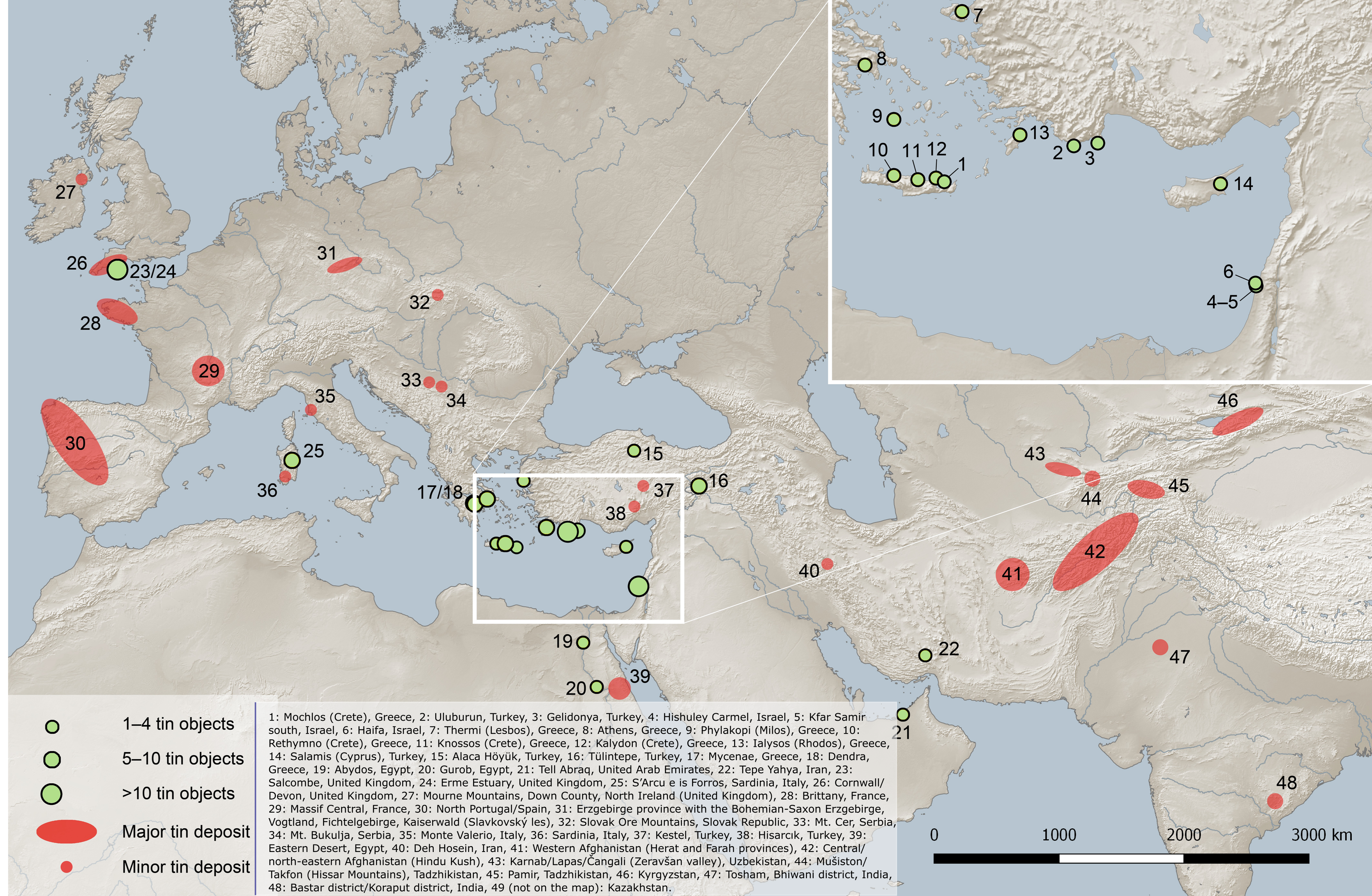
English: Map of bronze-age tin finds: objects in the eastern Mediterranean and the Near East, and major and minor tin deposits.
Modified for Wikimedia Commons. The original version can be found at File:Map of Eurasia showing the locations of the tin ingots mentioned in the text (green dots), other tin objects in the eastern Mediterranean and the Near East before 1000 BCE (yellow dots) and major and minor tin deposits.png Legend: 1: Mochlos (Crete), Greece, 2: Uluburun, Turkey, 3: Gelidonya, Turkey, 4: Hishuley Carmel, Israel, 5: Kfar Samir south, Israel, 6: Haifa, Israel, 7: Thermi (Lesbos), Greece, 8: Athens, Greece, 9: Phylakopi (Milos), Greece, 10: Rethymno (Crete), Greece, 11: Knossos (Crete), Greece, 12: Kalydon (Crete), Greece, 13: Ialysos (Rhodos), Greece, 14: Salamis (Cyprus), Turkey, 15: Alaca Höyük, Turkey, 16: Tülintepe, Turkey, 17: Mycenae, Greece, 18: Dendra, Greece, 19: Abydos, Egypt, 20: Gurob, Egypt, 21: Tell Abraq, United Arab Emirates, 22: Tepe Yahya, Iran, 23: Salcombe, United Kingdom, 24: Erme Estuary, United Kingdom, 25: S’Arcu e is Forros, Sardinia, Italy, 26: Cornwall/Devon, United Kingdom, 27: Mourne Mountains, Down County, North Ireland (United Kingdom), 28: Brittany, France, 29: Massif Central, France, 30: North Portugal/Spain, 31: Erzgebirge province with the Bohemian-Saxon Erzgebirge, Vogtland, Fichtelgebirge, Kaiserwald (Slavkovský les), 32: Slovak Ore Mountains, Slovak Republic, 33: Mt. Cer, Serbia, 34: Mt. Bukulja, Serbia, 35: Monte Valerio, Italy, 36: Sardinia, Italy, 37: Kestel, Turkey, 38: Hisarcık, Turkey, 39: Eastern Desert, Egypt, 40: Deh Hosein, Iran, 41: Western Afghanistan (Herat and Farah provinces), 42: Central/north-eastern Afghanistan (Hindu Kush), 43: Karnab/Lapas/Čangali (Zeravšan valley), Uzbekistan, 44: Mušiston/Takfon (Hissar Mountains), Tadzhikistan, 45: Pamir, Tadzhikistan, 46: Kyrgyzstan, 47: Tosham, Bhiwani district, India, 48: Bastar district/Koraput district, India, 49 (not on the map): Kazakhstan. Size of green symbols on the inset map do not correlate with number of objects as on the main map. Original publication: Berger, Daniel (2019-06-26). "Isotope systematics and chemical composition of tin ingots from Mochlos (Crete) and other Late Bronze Age sites in the eastern Mediterranean Sea: An ultimate key to tin provenance?". PLOS ONE 14 (6): e0218326. DOI:10.1371/journal.pone.0218326. PMID 31242218. PMC: 6594607. ISSN 1932-6203. Original map credit: (map: D. Berger, C. Frank using Natural Earth geo data and QGIS Geographic Information System. QGIS Development Team, 2019. Open Source Geospatial Foundation. http://qgis.org). Original map license:
|
||
| תאריך יצירה | |||
| מקור | נוצר על־ידי מעלה היצירה | ||
| יוצר | Danny lost |
,_other_tin_objects_in_the_eastern_Mediterranean_and_the_Near_East_before_1000_BCE_(yellow_dots)_and_major_and_minor_tin_deposits.png)
רישיון
- הנכם רשאים:
- לשתף – להעתיק, להפיץ ולהעביר את העבודה
- לערבב בין עבודות – להתאים את העבודה
- תחת התנאים הבאים:
- ייחוס – יש לתת ייחוס הולם, לתת קישור לרישיון, ולציין אם נעשו שינויים. אפשר לעשות את זה בכל צורה סבירה, אבל לא בשום צורה שמשתמע ממנה שמעניק הרישיון תומך בך או בשימוש שלך.
היסטוריית הקובץ
ניתן ללחוץ על תאריך/שעה כדי לראות את הקובץ כפי שנראה באותו זמן.
| תאריך/שעה | תמונה ממוזערת | ממדים | משתמש | הערה | |
|---|---|---|---|---|---|
| נוכחית | 22:43, 27 בפברואר 2022 | | 2,300 × 3,521 (9.01 מ"ב) | Danny lost | Uploaded own work with UploadWizard |
שימוש בקובץ
הדף הבא משתמש בקובץ הזה:
שימוש גלובלי בקובץ
אתרי הוויקי השונים הבאים משתמשים בקובץ זה:
- שימוש באתר de.wikipedia.org
- שימוש באתר en.wikipedia.org
- שימוש באתר uk.wikipedia.org
- שימוש באתר www.wikidata.org