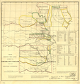
קובץ:Map of Indian territory 1836.png

תוכן הדף אינו נתמך בשפות אחרות.
מתוך ויקיפדיה, האנציקלופדיה החופשית

לקובץ המקורי(7,477 × 9,136 פיקסלים, גודל הקובץ: 92.32 מ"ב, סוג MIME‏: image/png)

ויקישיתוף זהו קובץ שמקורו במיזם ויקישיתוף. תיאורו בדף תיאור הקובץ המקורי (בעברית) מוצג למטה.

תקציר

Warning The original file is very high-resolution. It might not load properly or could cause your browser to freeze when opened at full size.
תיאור
English: 1836 map showing the lands assigned to emigrant Indians west of Arkansas and Missouri of the Indian Territory jurisdiction — in the U.S. From: [Documents concerning Col. Henry Dodge's expedition to the Rocky Mountains], House Document 181, 24th Cong., 1st session, 1835-36, serial 289.
תאריך יצירה
מקור https://www.loc.gov/item/99446197/
יוצר A Jones, Adj. Genl. Topographic Bureau
אישורים והיתרים
(שימוש חוזר בקובץ זה)
image זה זמין במחלקת {{{division_name}}} תחת מספר מזהה: חסר.

תבנית זו אינה מעידה על מצב זכויות היוצרים של היצירה. לתבנית זו יש לצרף תבנית רישיון מתאימה.

العربية  беларуская (тарашкевіца)  বাংলা  čeština  Deutsch  English  español  فارسی  suomi  français  galego  עברית  magyar  Bahasa Indonesia  italiano  日本語  lietuvių  македонски  മലയാളം  Nederlands  polski  português  português do Brasil  română  русский  sicilianu  slovenčina  slovenščina  Türkçe  українська  简体中文  繁體中文  +/−

רישיון

Public domain
יצירה זו נמצאת בנחלת הכלל במדינת המקור ובמדינות אחרות בהם תקופת זכויות היוצרים היא משך חיי היוצר ו-70 שנה (או פחות) מפטירתו.

You must also include a United States public domain tag to indicate why this work is in the public domain in the United States. Note that a few countries have copyright terms longer than 70 years: Mexico has 100 years, Jamaica has 95 years, Colombia has 80 years, and Guatemala and Samoa have 75 years. This image may not be in the public domain in these countries, which moreover do not implement the rule of the shorter term. Honduras has a general copyright term of 75 years, but it does implement the rule of the shorter term. Copyright may extend on works created by French who died for France in World War II (more information), Russians who served in the Eastern Front of World War II (known as the Great Patriotic War in Russia) and posthumously rehabilitated victims of Soviet repressions (more information).

יומן העלאה מקורי

תיאור הקובץ המקורי נמצא כאן. כל שמות המשתמשים הבאים מתייחסים ל-en.wikipedia.
  • 2005-01-11 05:53 CPret 698×744×8 (670317 bytes) Map of Indian territory - 1836

כיתובים

נא להוסיף משפט שמסביר מה הקובץ מייצג

פריטים שמוצגים בקובץ הזה

מוצג

23 בפברואר 1836גרגוריאני

היסטוריית הקובץ

ניתן ללחוץ על תאריך/שעה כדי לראות את הקובץ כפי שנראה באותו זמן.

תאריך/שעהתמונה ממוזערתממדיםמשתמשהערה
נוכחית18:31, 5 במרץ 2018תמונה ממוזערת לגרסה מ־18:31, 5 במרץ 2018‪9,136 × 7,477‬ (92.32 מ"ב)Ww2censorHigher resolution from source converted from jpg to png
00:37, 7 באפריל 2008תמונה ממוזערת לגרסה מ־00:37, 7 באפריל 2008‪744 × 698‬ (655 ק"ב)File Upload Bot (Magnus Manske) {{BotMoveToCommons|en.wikipedia}} {{Information |Description={{en|Map of Indian territory - 1836 '''Source:''' Image is from the [http://memory.loc.gov/ammem/gmdhtml/gmdhome.html Library of Congress] and is in the public domain.<br> '''Area:''' 698x744

הדפים הבאים משתמשים בקובץ הזה:

שימוש גלובלי בקובץ

אתרי הוויקי השונים הבאים משתמשים בקובץ זה:

מטא־נתונים