
קובץ:Map of East and West Florida in 1819.jpg

אין גרסה ברזולוציה גבוהה יותר.
Map_of_East_and_West_Florida_in_1819.jpg (632 × 420 פיקסלים, גודל הקובץ: 148 ק"ב, סוג MIME: image/jpeg)
| זהו קובץ שמקורו במיזם ויקישיתוף. תיאורו בדף תיאור הקובץ המקורי (בעברית) מוצג למטה. |
תקציר
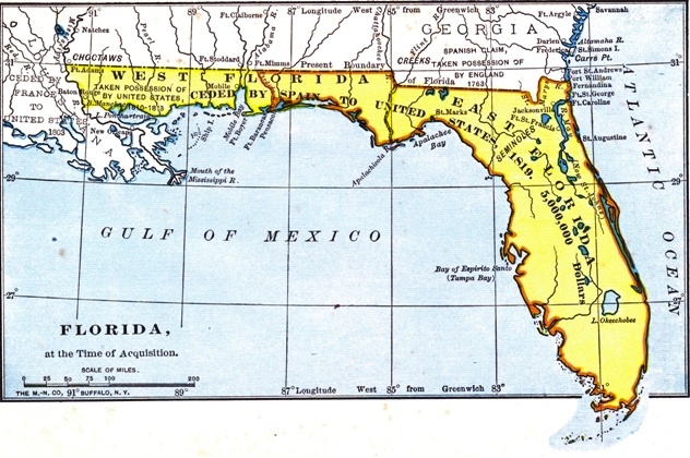
| תיאור |
English: The British had divided Florida into the administrative units of East Florida and West Florida during their ownership (1763–1783). |
| תאריך יצירה | |
| מקור |
Project Gutenberg http://www.gutenberg.org/files/35558/35558-h/images/2.jpg |
| יוצר | לא ידוע |
רישיון
This work is in the public domain in the United States because it was published (or registered with the U.S. Copyright Office) before January 1, 1929.
Public domain works must be out of copyright in both the United States and in the source country of the work in order to be hosted on the Commons. If the work is not a U.S. work, the file must have an additional copyright tag indicating the copyright status in the source country.
Note: This tag should not be used for sound recordings. |
היסטוריית הקובץ
ניתן ללחוץ על תאריך/שעה כדי לראות את הקובץ כפי שנראה באותו זמן.
| תאריך/שעה | תמונה ממוזערת | ממדים | משתמש | הערה | |
|---|---|---|---|---|---|
| נוכחית | 21:09, 16 ביולי 2019 | | 420 × 632 (148 ק"ב) | Carlstak | User created page with UploadWizard |
שימוש בקובץ
הדף הבא משתמש בקובץ הזה:
שימוש גלובלי בקובץ
אתרי הוויקי השונים הבאים משתמשים בקובץ זה:
- שימוש באתר en.wikipedia.org
- שימוש באתר mt.wikipedia.org