
קובץ:Map of Colchis, Iberia, Albania, and the neighbouring countries ca 1770.jpg

גודל התצוגה המקדימה הזאת: 800 × 598 פיקסלים. רזולוציות אחרות: 320 × 239 פיקסלים | 640 × 479 פיקסלים | 1,016 × 760 פיקסלים.
לקובץ המקורי (1,016 × 760 פיקסלים, גודל הקובץ: 194 ק"ב, סוג MIME: image/jpeg)
| זהו קובץ שמקורו במיזם ויקישיתוף. תיאורו בדף תיאור הקובץ המקורי (בעברית) מוצג למטה. |
תקציר
| תיאור |
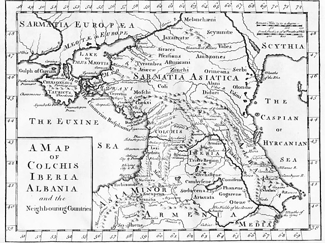
English: "A Map of Colchis, Iberia, Albania, and the neighbouring countries". A map of the Caucasus / Crimea (Chersonesus Tauricus)/ southern Russia region during classical antiquity (the ancient period). Note that the "Albania" referred to was on the Caspian Sea (not the modern Albania in the Balkans). Copper-engraved map, no publisher or date, London, ca 1770 (or 1729?).
Deutsch: Kaukasus mit Siedlungsgebieten von Sarmaten und Amazonen in der Antike, Kupferstich von ca. 1770
Français : La Colchide, l’Ibérie (orientale), l’Albanie (orientale) et les régions voisines
ქართული: ანტიკური ხანის კოლხეთი, ბერძნულ წყაროებზე დაყრდნობით, დაბეჭდილია ლონდონში, 1770.
Nederlands: Kaart van de Kaukasus, ca. 1770
Русский: «Европейская Сарматия». Карта основана на греческих литературных источниках, напечатана в Лондоне в 1770 |
| תאריך יצירה | בסביבות 1770 |
| מקור |
|
| יוצר | last upload en:User:AnonMoos |
רישיון
|
עבודת אמנות דו-מימדית זו המוצגת בתמונה שוחררה לרשות הציבור בכל העולם בעקבות תאריך מותו של היוצר, או תאריך פרסום היצירה. לפיכך, תצלום היצירה גם הוא ברשות הציבור.
הודעה זו תקפה לגבי התצלומים שנוצרו בארצות הברית, בגרמניה ובמדינות רבות נוספות.
| ||||
יומן העלאה מקורי
File upload history on en:
- 20:53, 27 October 2005 . . AnonMoos (Talk) . . 1016x760 (198173 bytes) (Version of image losslessly cropped to region of interest with Jpegcrop program. )
- 20:32, 3 July 2005 . . PANONIAN (Talk) . . 1254x760 (224060 bytes) (historic map )
| date/time | username | resolution | size | edit summary | |
|---|---|---|---|---|---|
| 14:53, 29 December 2005 | User:Ustas | <a href="http://upload.wikimedia.org/wikipedia/commons/d/df/1729.jpg"><img alt="Thumbnail for version as of 14:53, 29 December 2005" src="http://upload.wikimedia.org/wikipedia/commons/thumb/d/df/1729.jpg/120px-1729.jpg" width="120" height="90" border="0" /></a> | 1,016×760 | 194 KB | {{Information |Description = Copper-engraved map, no publisher or date, London, ca 1770. |Source = <a href="http://en.wikipedia.org/wiki/Image:1729.jpg" class="extiw" title="en:Image:1729.jpg">en:Image:1729.jpg</a>, [http://www.village-atlas.com/ancient/ancient.html] |Date = |Author = last upload <a href="http://en.wikipedia.org/wiki/User:AnonMoos" class="extiw" title="en:User:AnonMoos">en:User:AnonMoos</a> |Permission = PD |other_ver |
היסטוריית הקובץ
ניתן ללחוץ על תאריך/שעה כדי לראות את הקובץ כפי שנראה באותו זמן.
| תאריך/שעה | תמונה ממוזערת | ממדים | משתמש | הערה | |
|---|---|---|---|---|---|
| נוכחית | 19:02, 22 באוקטובר 2008 | | 760 × 1,016 (194 ק"ב) | BetacommandBot | move approved by: User:Deadstar This image was moved from Image:1729.jpg {{Information |Description = "A Map of Colchis, Iberia, Albania, and the neighbouring countries". A map of the Caucasus / Crimea / southern Russia region during classical |
שימוש בקובץ
שימוש גלובלי בקובץ
אתרי הוויקי השונים הבאים משתמשים בקובץ זה:
- שימוש באתר als.wikipedia.org
- שימוש באתר an.wikipedia.org
- שימוש באתר ar.wikipedia.org
- שימוש באתר az.wikipedia.org
- שימוש באתר ba.wikipedia.org
- שימוש באתר bn.wikipedia.org
- שימוש באתר ca.wikipedia.org
- שימוש באתר co.wikipedia.org
- שימוש באתר cy.wikipedia.org
- שימוש באתר da.wikipedia.org
- שימוש באתר de.wikipedia.org
- שימוש באתר el.wikipedia.org
- שימוש באתר en.wikipedia.org
- שימוש באתר es.wikipedia.org
- שימוש באתר eu.wikipedia.org
- שימוש באתר fa.wikipedia.org
- שימוש באתר fi.wikipedia.org
- שימוש באתר fr.wikipedia.org
- שימוש באתר fy.wikipedia.org
- שימוש באתר gl.wikipedia.org
- שימוש באתר hr.wikipedia.org
- שימוש באתר hu.wikipedia.org
- שימוש באתר hyw.wikipedia.org
- שימוש באתר it.wikipedia.org