
קובץ:Low-Island-location-map.png

גודל התצוגה המקדימה הזאת: 800 × 548 פיקסלים. רזולוציות אחרות: 320 × 219 פיקסלים | 640 × 439 פיקסלים | 1,024 × 702 פיקסלים | 1,280 × 877 פיקסלים | 1,669 × 1,144 פיקסלים.
לקובץ המקורי (1,669 × 1,144 פיקסלים, גודל הקובץ: 150 ק"ב, סוג MIME: image/png)
| זהו קובץ שמקורו במיזם ויקישיתוף. תיאורו בדף תיאור הקובץ המקורי (בעברית) מוצג למטה. |
תקציר
| תיאור |
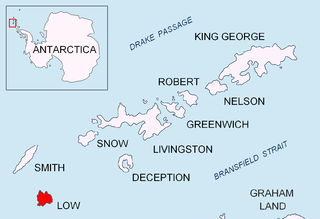
English: Location map of Low Island in the South Shetland Islands. |
| תאריך יצירה | |
| מקור | נוצר על־ידי מעלה היצירה |
| יוצר | Apcbg |
רישיון
אני, בעל זכויות היוצרים על היצירה הזאת, מפרסם אותה בזאת תחת הרישיונות הבאים:
הקובץ הזה מתפרסם לפי תנאי רישיון קריאייטיב קומונז ייחוס-שיתוף זהה 3.0 לא מותאם.
- הנכם רשאים:
- לשתף – להעתיק, להפיץ ולהעביר את העבודה
- לערבב בין עבודות – להתאים את העבודה
- תחת התנאים הבאים:
- ייחוס – יש לתת ייחוס הולם, לתת קישור לרישיון, ולציין אם נעשו שינויים. אפשר לעשות את זה בכל צורה סבירה, אבל לא בשום צורה שמשתמע ממנה שמעניק הרישיון תומך בך או בשימוש שלך.
- שיתוף זהה – אם תיצרו רמיקס, תשנו, או תבנו על החומר, חובה עליכם להפיץ את התרומות שלך לפי תנאי רישיון זהה או תואם למקור.

|
מוענקת בכך הרשות להעתיק, להפיץ או לשנות את המסמך הזה, לפי תנאי הרישיון לשימוש חופשי במסמכים של גנו, גרסה 1.2 או כל גרסה מאוחרת יותר שתפורסם על־ידי המוסד לתוכנה חופשית; ללא פרקים קבועים, ללא טקסט עטיפה קדמית וללא טקסט עטיפה אחורית. עותק של הרישיון כלול בפרק שכותרתו הרישיון לשימוש חופשי במסמכים של גנו. |
הנכם מוזמנים לבחור את הרישיון הרצוי בעיניכם.
היסטוריית הקובץ
ניתן ללחוץ על תאריך/שעה כדי לראות את הקובץ כפי שנראה באותו זמן.
| תאריך/שעה | תמונה ממוזערת | ממדים | משתמש | הערה | |
|---|---|---|---|---|---|
| נוכחית | 20:29, 24 באוגוסט 2010 | | 1,144 × 1,669 (150 ק"ב) | Apcbg | + location in Antarctica |
| 21:48, 27 באפריל 2010 |  | 1,144 × 1,669 (5.47 מ"ב) | Apcbg | {{Information |Description={{en|1=Location map of Low Island in the South Shetland Islands.}} |Source={{own}} |Author=Apcbg |Date=2010-04-27 |Permission= |other_versions= }} Category:Maps of Antarctica |
שימוש בקובץ
הדף הבא משתמש בקובץ הזה:
שימוש גלובלי בקובץ
אתרי הוויקי השונים הבאים משתמשים בקובץ זה:
- שימוש באתר az.wikipedia.org
- שימוש באתר bg.wikipedia.org
- שימוש באתר ca.wikipedia.org
- שימוש באתר ceb.wikipedia.org
- שימוש באתר en.wikipedia.org
- Low Island (South Shetland Islands)
- Solnik Point
- Kazichene Cove
- Teshel Cove
- Malina Cove
- Cape Wallace
- Jameson Point
- Limets Peninsula
- Prisad Island
- Beslen Island
- Zebil Island
- Glumche Island
- Lyutibrod Rocks
- Smochevo Cove
- Ugorelets Point
- Presnakov Island
- Aurelia Island
- Venev Point
- Mateev Point
- Groma Rock
- Dioptra Island
- שימוש באתר es.wikipedia.org
- שימוש באתר eu.wikipedia.org
- שימוש באתר it.wikipedia.org
- שימוש באתר ja.wikipedia.org
- שימוש באתר ko.wikipedia.org
- שימוש באתר lv.wikipedia.org
- שימוש באתר nn.wikipedia.org
- שימוש באתר pl.wikipedia.org
- שימוש באתר ru.wikipedia.org
- שימוש באתר uk.wikipedia.org
- שימוש באתר www.wikidata.org
- שימוש באתר zh.wikipedia.org