
קובץ:Lake Manly system.png
אין גרסה ברזולוציה גבוהה יותר.
Lake_Manly_system.png (290 × 315 פיקסלים, גודל הקובץ: 16 ק"ב, סוג MIME: image/png)
| זהו קובץ שמקורו במיזם ויקישיתוף. תיאורו בדף תיאור הקובץ המקורי (בעברית) מוצג למטה. |
| תיאור |
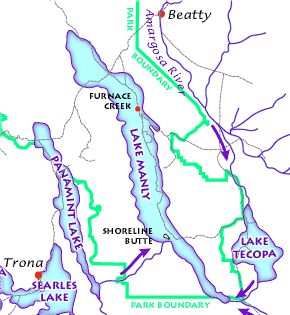
English: The Lake Manly lake system as it might have looked during its last maximum extent 22,000 years ago. (USGS image). The Lake Manly lake system as it might have looked during its last maximum extent 22,000 years ago. Arrows indicate river water flow, gray lines are current highways, and red dots are towns. (USGS image). The Lake Manly lake system as it might have looked during its last maximum extent 22,000 years ago. (USGS image).
Français : Le Lac Manly tel qu'il devait être à son extension maximale, il y a 22 000 années. (Document de l'USGS).
Magyar: A Manly-tó és a környező vízrendszer kb. 22 000 évvel ezelőtt.
Български: Най-вероятно така е изглеждала Долината на смъртта преди 22 000 години. |
|||||||||
| מקור |
Death Valley Geology Field Trip: Shoreline Butte: |
|||||||||
| אישורים והיתרים (שימוש חוזר בקובץ זה) |
|
|||||||||
| Geotemporal data | ||||||||||
| Bounding box |
|
|||||||||
| Georeferencing | ||||||||||
| גרסאות אחרות |
|
|||||||||

היסטוריית הקובץ
ניתן ללחוץ על תאריך/שעה כדי לראות את הקובץ כפי שנראה באותו זמן.
| תאריך/שעה | תמונה ממוזערת | ממדים | משתמש | הערה | |
|---|---|---|---|---|---|
| נוכחית | 20:43, 23 בפברואר 2012 | | 315 × 290 (16 ק"ב) | Ras67 | cropped |
| 11:48, 12 במרץ 2006 |  | 316 × 291 (17 ק"ב) | Urban~commonswiki | USGS image from http://www2.nature.nps.gov/geology/usgsnps/deva/ftsho1.html<br><br>{{PD-USGov}} Category:Death Valley |
שימוש בקובץ
הדף הבא משתמש בקובץ הזה:
שימוש גלובלי בקובץ
אתרי הוויקי השונים הבאים משתמשים בקובץ זה:
- שימוש באתר bg.wikipedia.org
- שימוש באתר de.wikipedia.org
- שימוש באתר fr.wikipedia.org
- שימוש באתר hu.wikipedia.org
- שימוש באתר it.wikipedia.org
- שימוש באתר zh.wikipedia.org