
קובץ:La Guajira Topographic 2.png

גודל התצוגה המקדימה הזאת: 733 × 600 פיקסלים. רזולוציות אחרות: 293 × 240 פיקסלים | 587 × 480 פיקסלים | 939 × 768 פיקסלים | 1,252 × 1,024 פיקסלים | 1,925 × 1,575 פיקסלים.
לקובץ המקורי (1,925 × 1,575 פיקסלים, גודל הקובץ: 3.35 מ"ב, סוג MIME: image/png)
| זהו קובץ שמקורו במיזם ויקישיתוף. תיאורו בדף תיאור הקובץ המקורי (בעברית) מוצג למטה. |
תקציר
| תיאור |
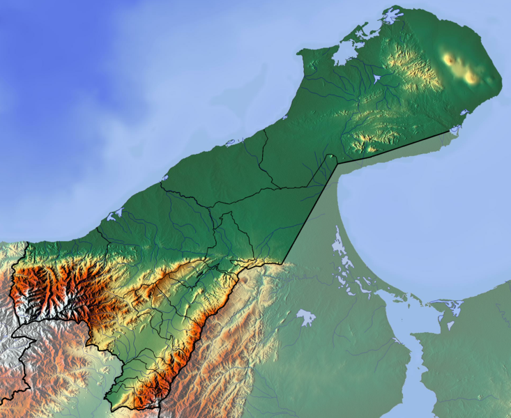
Français : La Guajira dept |
| תאריך יצירה | |
| מקור | נוצר על־ידי מעלה היצירה (backgroung : http://www.maps-for-free.com) |
| יוצר | Dr Brains |
רישיון
אני, בעל זכויות היוצרים על היצירה הזאת, מפרסם אותה בזאת תחת הרישיונות הבאים:

|
מוענקת בכך הרשות להעתיק, להפיץ או לשנות את המסמך הזה, לפי תנאי הרישיון לשימוש חופשי במסמכים של גנו, גרסה 1.2 בלבד כפי שפורסמה על־ידי המוסד לתוכנה חופשית; ללא פרקים קבועים, ללא טקסט עטיפה קדמית וללא טקסט עטיפה אחורית. עותק של הרישיון כלול בפרק שכותרתו הרישיון לשימוש חופשי במסמכים של גנו. | 1.2 בלבד |
|
|
מוענקת בכך הרשות להעתיק, להפיץ או לשנות את המסמך הזה, לפי תנאי הרישיון לשימוש חופשי במסמכים של גנו, גרסה 1.3 או כל גרסה מאוחרת יותר שתפורסם על־ידי המוסד לתוכנה חופשית; ללא פרקים קבועים, ללא טקסט עטיפה קדמית וללא טקסט עטיפה אחורית. עותק של הרישיון כלול בפרק שכותרתו הרישיון לשימוש חופשי במסמכים של גנו.
|
If this file is eligible for relicensing, it may also be used under the Creative Commons Attribution-ShareAlike 3.0 license. The relicensing status of this image needs to be manually reviewed by an experienced user. You can help.
|
הנכם מוזמנים לבחור את הרישיון הרצוי בעיניכם.
היסטוריית הקובץ
ניתן ללחוץ על תאריך/שעה כדי לראות את הקובץ כפי שנראה באותו זמן.
| תאריך/שעה | תמונה ממוזערת | ממדים | משתמש | הערה | |
|---|---|---|---|---|---|
| נוכחית | 16:44, 9 ביוני 2012 | | 1,575 × 1,925 (3.35 מ"ב) | Dr Brains |
שימוש בקובץ
הדף הבא משתמש בקובץ הזה:
שימוש גלובלי בקובץ
אתרי הוויקי השונים הבאים משתמשים בקובץ זה:
- שימוש באתר bg.wikipedia.org
- שימוש באתר en.wikipedia.org
- Mosque of Omar Ibn Al-Khattab
- La Guajira Department
- Module:Location map/data/Colombia La Guajira Department/doc
- Cesar-Ranchería Basin
- Cocinetas Basin
- Macarao Formation
- Siamaná Formation
- Uitpa Formation
- Jimol Formation
- Castilletes Formation
- Ware Formation
- Module:Location map/data/Colombia La Guajira Department
- La Guajira Terrane
- שימוש באתר es.wikipedia.org
- Cabo de la Vela
- Punta Gallinas
- Puerto Bolívar (La Guajira)
- Cerro La Teta
- Bahía Honda (Colombia)
- Cerro Palúa
- Wikiproyecto:Ilustración/Taller de Cartografía/Realizaciones/América del Sur
- Serranía de Macuira
- Plantilla:Mapa de localización de La Guajira
- Formación Cerrejón
- Bahía Hondita
- Bahía Portete
- Montes de Oca (Guajira)
- Cerro Cerrejón
- Formación Castilletes
- שימוש באתר fa.wikipedia.org
- שימוש באתר fr.wikipedia.org
- La Guajira
- Punta Gallinas
- Serranía de Macuira
- Parc national naturel de Macuira
- Maicao
- Urumita
- Manaure (La Guajira)
- Villanueva (La Guajira)
- Uribia
- San Juan del Cesar
- La Jagua del Pilar
- Hatonuevo
- Fonseca (La Guajira)
- El Molino (La Guajira)
- Distracción
- Dibulla
- Barrancas (La Guajira)
- Modèle:Géolocalisation/La Guajira
- Modèle:Géolocalisation/La Guajira/Documentation