
קובץ:Gulf of Izmit, Turkey.JPG

גודל התצוגה המקדימה הזאת: 800 × 532 פיקסלים. רזולוציות אחרות: 320 × 213 פיקסלים | 640 × 425 פיקסלים | 1,024 × 681 פיקסלים | 1,280 × 851 פיקסלים | 2,560 × 1,701 פיקסלים | 4,288 × 2,850 פיקסלים.
לקובץ המקורי (4,288 × 2,850 פיקסלים, גודל הקובץ: 2.6 מ"ב, סוג MIME: image/jpeg)
| זהו קובץ שמקורו במיזם ויקישיתוף. תיאורו בדף תיאור הקובץ המקורי (בעברית) מוצג למטה. |
תקציר
| תיאור |
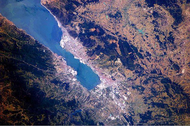
English: This astronaut photograph highlights the metropolitan area of Izmit along the northern and eastern shores of the Sea of Marmara, at the end of the Gulf of Izmit. Commercial and industrial centres—including petroleum refineries and automobile factories—are recognizable by large structures with white rooftops. The smaller city of Gölcük on the southern shoreline of the Gulf is the location of a Turkish naval facility and another automobile factory. Both urban areas are built primarily on flat lowlands adjacent to the Gulf, with green vegetation marking highland areas to the north of Izmit and south of Gölcük. |
| תאריך יצירה | |
| מקור | NASA Earth Observatory |
| יוצר | ISS Expedition 24 crew |
| מיקום המצלמה | | תמונה זו ותמונות נוספות במיקום: OpenStreetMap |
|---|
This image or video was catalogued by Johnson Space Center of the United States National Aeronautics and Space Administration (NASA) under Photo ID: ISS024-E-10162. This tag does not indicate the copyright status of the attached work. A normal copyright tag is still required. See Commons:Licensing. Other languages:
|
Image acquired with a Nikon D2Xs digital camera using a 180 mm lens, and is provided by the ISS Crew Earth Observations experiment and Image Science & Analysis Laboratory, Johnson Space Center.
רישיון
| קובץ זה נמצא ברשות הציבור מכיוון שהוא נוצר על ידי נאס"א. מדיניות זכויות היוצרים של נאס"א קובעת ש"חומרים של NASA אינם מוגנים בזכויות יוצרים אלא אם צוין אחרת". (דף מדיניות זכויות היוצרים ב-NASA או מדיניות שימוש בתמונות ב-JPL). | ||
 |
אזהרות:
|
היסטוריית הקובץ
ניתן ללחוץ על תאריך/שעה כדי לראות את הקובץ כפי שנראה באותו זמן.
| תאריך/שעה | תמונה ממוזערת | ממדים | משתמש | הערה | |
|---|---|---|---|---|---|
| נוכחית | 12:56, 23 באוגוסט 2010 | | 2,850 × 4,288 (2.6 מ"ב) | Originalwana | {{Information |Description={{en|1=This astronaut photograph highlights the metropolitan area of Izmit along the northern and eastern shores of the Sea of Marmara, at the end of the Gulf of Izmit. [[:Category:Commerc |
שימוש בקובץ
הדף הבא משתמש בקובץ הזה:
שימוש גלובלי בקובץ
אתרי הוויקי השונים הבאים משתמשים בקובץ זה:
- שימוש באתר ar.wikipedia.org
- שימוש באתר az.wikipedia.org
- שימוש באתר ba.wikipedia.org
- שימוש באתר bg.wikipedia.org
- שימוש באתר bn.wikipedia.org
- שימוש באתר ca.wikipedia.org
- שימוש באתר ceb.wikipedia.org
- שימוש באתר cs.wikipedia.org
- שימוש באתר en.wikipedia.org
- שימוש באתר es.wikipedia.org
- שימוש באתר eu.wikipedia.org
- שימוש באתר fa.wikipedia.org
- שימוש באתר fr.wikipedia.org
- שימוש באתר hr.wikipedia.org
- שימוש באתר id.wikipedia.org
- שימוש באתר ilo.wikipedia.org
- שימוש באתר it.wikipedia.org
- שימוש באתר ka.wikipedia.org
- שימוש באתר mt.wikipedia.org
- שימוש באתר nl.wikipedia.org
- שימוש באתר nn.wikipedia.org
- שימוש באתר ru.wikipedia.org
- שימוש באתר tr.wikipedia.org
- שימוש באתר tr.wikivoyage.org
- שימוש באתר www.wikidata.org
- שימוש באתר zh.wikipedia.org