
קובץ:Gulf of Guinea (English).jpg

גודל התצוגה המקדימה הזאת: 800 × 500 פיקסלים. רזולוציות אחרות: 320 × 200 פיקסלים | 640 × 400 פיקסלים | 891 × 557 פיקסלים.
לקובץ המקורי (891 × 557 פיקסלים, גודל הקובץ: 155 ק"ב, סוג MIME: image/jpeg)
| זהו קובץ שמקורו במיזם ויקישיתוף. תיאורו בדף תיאור הקובץ המקורי (בעברית) מוצג למטה. |
.jpg)
.jpg?uselang=he)
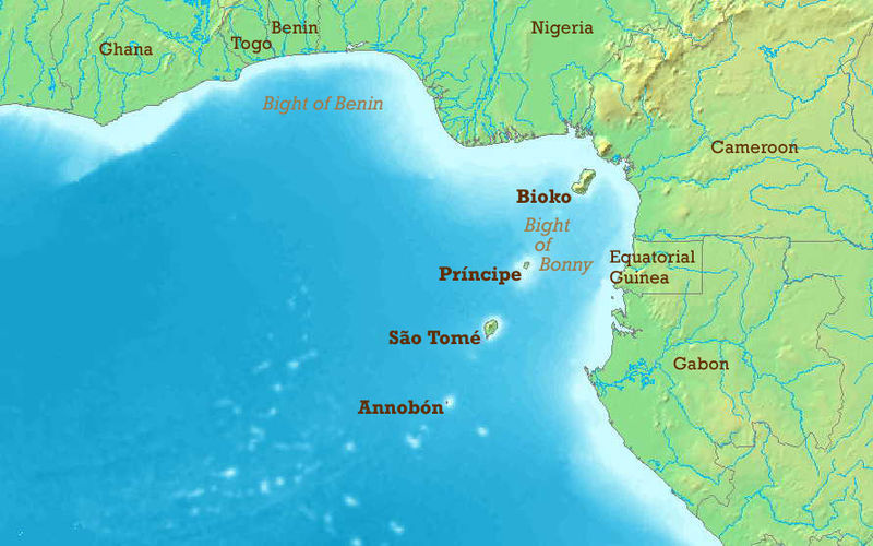
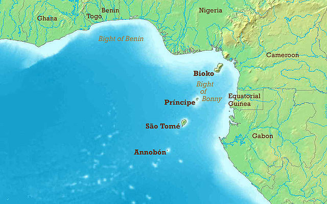
The Gulf of Guinea with English labels. Map modified from Image:Golf von Guinea.jpg.
- Other_versions available :
- Blank : Image:Gulf_of_Guinea_(blank).jpg
- French : Image:Gulf_of_Guinea-fr.jpg
- German : Image:Golf_von_Guinea.jpg
.jpg)

|
מוענקת בכך הרשות להעתיק, להפיץ או לשנות את המסמך הזה, לפי תנאי הרישיון לשימוש חופשי במסמכים של גנו, גרסה 1.2 או כל גרסה מאוחרת יותר שתפורסם על־ידי המוסד לתוכנה חופשית; ללא פרקים קבועים, ללא טקסט עטיפה קדמית וללא טקסט עטיפה אחורית. עותק של הרישיון כלול בפרק שכותרתו הרישיון לשימוש חופשי במסמכים של גנו. |
| הקובץ הזה מתפרסם לפי תנאי רישיון קריאייטיב קומונז ייחוס-שיתוף זהה 3.0 לא מותאם. | ||
| ||
| תבנית רישוי זו הוספה לקובץ כחלק מעדכון רישיון GFDL. |
היסטוריית הקובץ
ניתן ללחוץ על תאריך/שעה כדי לראות את הקובץ כפי שנראה באותו זמן.
| תאריך/שעה | תמונה ממוזערת | ממדים | משתמש | הערה | |
|---|---|---|---|---|---|
| נוכחית | 23:50, 23 במאי 2006 | | 557 × 891 (155 ק"ב) | Amcaja | The Gulf of Guinea with English labels. Map modified from Image:Golf von Guinea.jpg. {{GFDL}} Category:Guinea Category:Islands Category:Maps of the Atlantic Ocean Category:Maps of Benin Category:Maps of Cameroon [[Category:Maps |
שימוש בקובץ
הדפים הבאים משתמשים בקובץ הזה:
שימוש גלובלי בקובץ
אתרי הוויקי השונים הבאים משתמשים בקובץ זה:
- שימוש באתר af.wikipedia.org
- שימוש באתר ar.wikipedia.org
- שימוש באתר ast.wikipedia.org
- שימוש באתר azb.wikipedia.org
- שימוש באתר az.wikipedia.org
- שימוש באתר be-tarask.wikipedia.org
- שימוש באתר be.wikipedia.org
- שימוש באתר bg.wikipedia.org
- שימוש באתר bh.wikipedia.org
- שימוש באתר bn.wikipedia.org
- שימוש באתר br.wikipedia.org
- שימוש באתר bs.wikipedia.org
- שימוש באתר ca.wikipedia.org
- Golf de Benín
- Selva de terres baixes de São Tomé, Principe i Annobón
- Llista d'aeroports de São Tomé i Príncipe
- Frontera entre el Gabon i São Tomé i Príncipe
- Frontera entre Nigèria i São Tomé i Príncipe
- Frontera entre Guinea Equatorial i Nigèria
- Resolució 2018 del Consell de Seguretat de les Nacions Unides
- שימוש באתר cs.wikipedia.org
- שימוש באתר cv.wikipedia.org
- שימוש באתר da.wikipedia.org
- שימוש באתר de.wikipedia.org
- שימוש באתר el.wikipedia.org
- שימוש באתר en.wikipedia.org
.jpg)
.jpg)