
קובץ:Gaza from the Hills Muntar.jpg

לקובץ המקורי (902 × 768 פיקסלים, גודל הקובץ: 266 ק"ב, סוג MIME: image/jpeg)
| זהו קובץ שמקורו במיזם ויקישיתוף. תיאורו בדף תיאור הקובץ המקורי (בעברית) מוצג למטה. |
תקציר
| תיאור |
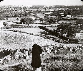
Image Title: Gaza from the Hills Muntar Image Description from historic lecture booklet: "This picture is taken two miles southwest of Gaza on the Hill Muntar. Gaza was the southern-most and strongest of five Royal Cities of Philistines. It has been made famous by the exploits of Samson. Tradition points out a place on the southwest side of town toward the left of the picture as the place where stood the gates of the Philistine city which Samson carried off (Judges 13). It is claimed by some that this is the hill whither Samson carried the gates. Gaza is about 100 feet high and stands in the midst of orchards. There is an abundance of figs, dates and olives. The soil is irrigated by well water and yields abundantly. Gaza is very closely connected with Old Testament history, being mentioned in almost every book. It was a town even before the call of Abraham, and now is the largest city close to the seacoast in Palestine. In the conquest of Joshua the territory of Gaza is mentioned as one which he was not able to subdue (Josh. 15:47) But is apparently continued through the times of Samuel, Saul, and David to be a Philistine city." Original Format: Lantern slides Original Collection: Visual Instruction Department Lantern Slides Item Number: P217:set 010 001 Restrictions: Permission to use must be obtained from the OSU Archives. Click here to view The Best of the Archives. Click here to view Oregon State University's other digital collections. We're happy for you to share this digital image within the spirit of The Commons; however, certain restrictions on high quality reproductions of the original physical version may apply. To read more about what “no known restrictions” means, please visit the OSU Archives website. |
| תאריך יצירה |
בסביבות |
| מקור | Gaza from the Hills Muntar |
| יוצר | OSU Special Collections & Archives |
| אישורים והיתרים (שימוש חוזר בקובץ זה) |
OSU Special Collections & Archives @ Flickr Commons |
רישיון
This image was taken from Flickr's The Commons. The uploading organization may have various reasons for determining that no known copyright restrictions exist, such as:
More information can be found at https://flickr.com/commons/usage/. Please add additional copyright tags to this image if more specific information about copyright status can be determined. See Commons:Licensing for more information. |
| תמונה זו שפורסמה במקור בפליקר, נבדקה ב־11 במרץ 2012 על ידי המפעיל או בקר ויקישיתוף Matanya, שאישר שהתמונה נמצאה בפליקר תחת הרישיון לעיל בתאריך זה. |
היסטוריית הקובץ
ניתן ללחוץ על תאריך/שעה כדי לראות את הקובץ כפי שנראה באותו זמן.
| תאריך/שעה | תמונה ממוזערת | ממדים | משתמש | הערה | |
|---|---|---|---|---|---|
| נוכחית | 18:24, 11 במרץ 2012 | | 768 × 902 (266 ק"ב) | Matanya | {{Information |Description=Image Title: Gaza from the Hills Muntar Image Description from historic lecture booklet: "This picture is taken two miles southwest of Gaza on the Hill Muntar. Gaza was the southern-most and strongest of five Royal Cities o... |
שימוש בקובץ
הדף הבא משתמש בקובץ הזה: