
קובץ:Framnes Mountains Satellite Image Map.jpg

גודל התצוגה המקדימה הזאת: 419 × 599 פיקסלים. רזולוציות אחרות: 168 × 240 פיקסלים | 335 × 480 פיקסלים | 537 × 768 פיקסלים | 716 × 1,024 פיקסלים | 1,432 × 2,048 פיקסלים | 8,256 × 11,808 פיקסלים.
לקובץ המקורי (8,256 × 11,808 פיקסלים, גודל הקובץ: 18.35 מ"ב, סוג MIME: image/jpeg)
| זהו קובץ שמקורו במיזם ויקישיתוף. תיאורו בדף תיאור הקובץ המקורי (בעברית) מוצג למטה. |
תקציר
| Warning | The original file is very high-resolution. It might not load properly or could cause your browser to freeze when opened at full size. |
|---|
| תיאור |
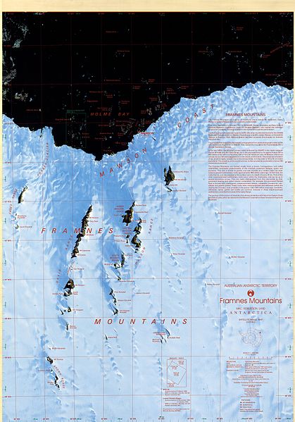
English: Satellite image map of Framnes Mountains, Mac. Robertson Land, Antarctica. This map was produced for the Australian Antarctic Division by AUSLIG (now Geoscience Australia) Commercial, in Australia, in 1997. The map is at a scale of 1:100000, and was produced from SPOT XS (WRS 246-491, 246-490) and Landsat TM (WRS 137-107, 135-108) scenes. It is projected on a Transverse Mercator projection, and shows glaciers/ice shelves, stations/bases, refuges/depots, specially protected areas (SPA), and gives some historical text information. The map has both geographical and UTM co-ordinates. |
| תאריך יצירה | |
| מקור | Framnes Mountains, Mac.Robertson Land |
| יוצר | Australian Antarctic Division (Australia) |
| אישורים והיתרים (שימוש חוזר בקובץ זה) |
Metadata details |
רישיון
הקובץ הזה מתפרסם לפי תנאי רישיון קריאייטיב קומונז ייחוס 3.0 לא מותאם.
ייחוס: Brolsma, H. (1999, updated 2014) Framnes Mountains Satellite Image Map 1:100000 Australian Antarctic Data Centre - CAASM Metadata (https://data.aad.gov.au/metadata/records/framnes_sat)
- הנכם רשאים:
- לשתף – להעתיק, להפיץ ולהעביר את העבודה
- לערבב בין עבודות – להתאים את העבודה
- תחת התנאים הבאים:
- ייחוס – יש לתת ייחוס הולם, לתת קישור לרישיון, ולציין אם נעשו שינויים. אפשר לעשות את זה בכל צורה סבירה, אבל לא בשום צורה שמשתמע ממנה שמעניק הרישיון תומך בך או בשימוש שלך.
This file, which was originally posted to
Framnes Mountains, Mac.Robertson Land, was reviewed on 13 January 2017 by reviewer INeverCry, who confirmed that it was available there under the stated license on that date.
|
היסטוריית הקובץ
ניתן ללחוץ על תאריך/שעה כדי לראות את הקובץ כפי שנראה באותו זמן.
| תאריך/שעה | תמונה ממוזערת | ממדים | משתמש | הערה | |
|---|---|---|---|---|---|
| נוכחית | 19:03, 6 בינואר 2017 | | 11,808 × 8,256 (18.35 מ"ב) | SteinsplitterBot | Bot: Image rotated by 180° |
| 17:47, 6 בינואר 2017 |  | 11,812 × 8,268 (18.36 מ"ב) | 4ing | =={{int:filedesc}}== {{Information |description={{en|1=Satellite image map of Framnes Mountains, Mac. Robertson Land, Antarctica. This map was produced for the Australian Antarctic Division by AUSLIG (now Geoscience Australia) Commercial, in Australia,... |
שימוש בקובץ
הדפים הבאים משתמשים בקובץ הזה:
שימוש גלובלי בקובץ
אתרי הוויקי השונים הבאים משתמשים בקובץ זה:
- שימוש באתר bg.wikipedia.org
- שימוש באתר ceb.wikipedia.org
- שימוש באתר de.wikipedia.org
- שימוש באתר en.wikipedia.org
- שימוש באתר es.wikipedia.org
- שימוש באתר nn.wikipedia.org
- שימוש באתר www.wikidata.org