
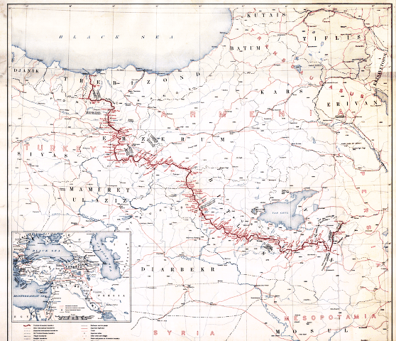
קובץ:First republic of Armenia-west borders by Woodrow Wilson.png
אין גרסה ברזולוציה גבוהה יותר.
First_republic_of_Armenia-west_borders_by_Woodrow_Wilson.png (558 × 480 פיקסלים, גודל הקובץ: 464 ק"ב, סוג MIME: image/png)
| זהו קובץ שמקורו במיזם ויקישיתוף. תיאורו בדף תיאור הקובץ המקורי (בעברית) מוצג למטה. |
תקציר
American memory collection http://hdl.loc.gov/loc.gmd/g7431f.ct000197
hi-res file is available at File:Boundary between Turkey and Armenia as determined by Woodrow Wilson.jpg
רישיון
This image is in the public domain in the United States because it only contains materials that originally came from the United States Geological Survey, an agency of the United States Department of the Interior. For more information, see the official USGS copyright policy.
|
היסטוריית הקובץ
ניתן ללחוץ על תאריך/שעה כדי לראות את הקובץ כפי שנראה באותו זמן.
| תאריך/שעה | תמונה ממוזערת | ממדים | משתמש | הערה | |
|---|---|---|---|---|---|
| נוכחית | 11:38, 4 בנובמבר 2007 | | 480 × 558 (464 ק"ב) | Rugby471 | shadow & stain |
| 10:37, 4 בנובמבר 2007 |  | 480 × 558 (179 ק"ב) | Rugby471 | color | |
| 01:00, 20 בדצמבר 2006 |  | 480 × 558 (464 ק"ב) | Electionworld | == Summary == American memory collection http://memory.loc.gov/cgi-bin/query/D?gmd:2:./temp/~ammem_He3o::@@@mdb=gmd,ww2map == Licensing == {{PD-USGov}} Category:Maps of the history of Armenia |
שימוש בקובץ
הדף הבא משתמש בקובץ הזה:
שימוש גלובלי בקובץ
אתרי הוויקי השונים הבאים משתמשים בקובץ זה:
- שימוש באתר ar.wikipedia.org
- שימוש באתר arz.wikipedia.org
- שימוש באתר ast.wikipedia.org
- שימוש באתר bg.wikipedia.org
- שימוש באתר ca.wikipedia.org
- שימוש באתר de.wikipedia.org
- שימוש באתר el.wikipedia.org
- שימוש באתר en.wikipedia.org
- שימוש באתר es.wikipedia.org
- שימוש באתר et.wikipedia.org
- שימוש באתר fa.wikipedia.org
- שימוש באתר fr.wikipedia.org
- שימוש באתר hr.wikipedia.org
- שימוש באתר hy.wikipedia.org
- שימוש באתר it.wikipedia.org
- שימוש באתר ka.wikipedia.org
- שימוש באתר lv.wikipedia.org
- שימוש באתר pl.wikipedia.org
- שימוש באתר pt.wikipedia.org
- שימוש באתר ro.wikipedia.org