
קובץ:Faults in Moenkopi Formation Moab Canyon Utah USA 01.jpg

גודל התצוגה המקדימה הזאת: 800 × 532 פיקסלים. רזולוציות אחרות: 320 × 213 פיקסלים | 640 × 426 פיקסלים | 1,024 × 681 פיקסלים | 1,280 × 851 פיקסלים | 3,008 × 2,000 פיקסלים.
לקובץ המקורי (3,008 × 2,000 פיקסלים, גודל הקובץ: 3.63 מ"ב, סוג MIME: image/jpeg)
| זהו קובץ שמקורו במיזם ויקישיתוף. תיאורו בדף תיאור הקובץ המקורי (בעברית) מוצג למטה. |
תקציר
| תיאור |
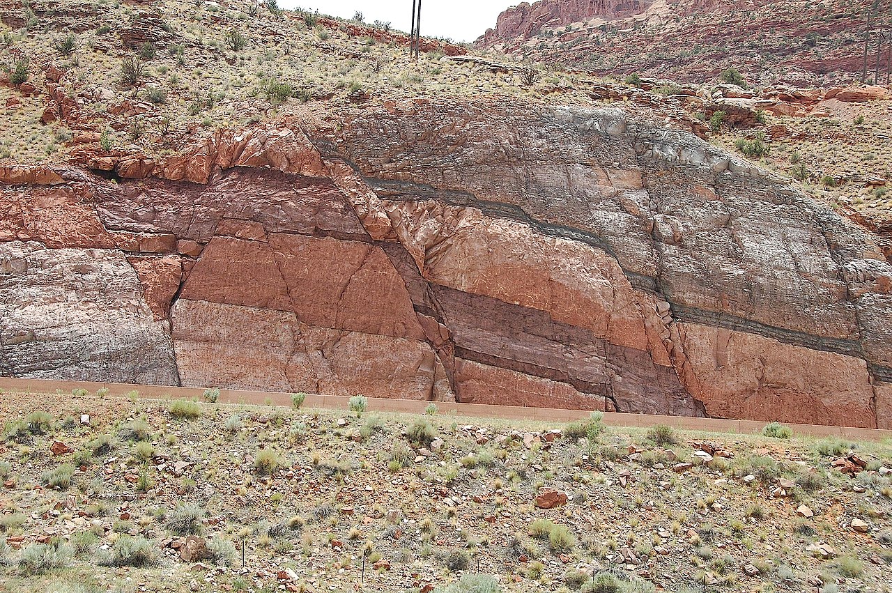
English: This image shows one of the only outcrops of the Pennsylvanian Period Honaker Trail Formation that may be viewed in the vicinity of Moab. In this setting the Honaker Trail Formation serves as the base of a strata graphic sequence which form the cliffs that occur on the west side of the Moab valley. This outcrop occurs across highway 191, immediately opposite and directly south of, the visitor center parking lot at Arches National Park. The Honaker Trail Formation underlies the visible strata throughout the area, but is buried and impossible to view elsewhere in the near vicinity of Moab. The fault and the road cut for highway 191 provide a rare circumstance where visitors to Moab, Arches National Park, and Canyonlands National Park may see this approximately 300 miilion year old Pennsylvanian Period layer of rock.
sources: 1) http://www.gly.uga.edu/railsback/VFT/VFTMoabFault.html 2) http://geology.byu.edu/home/sites/default/files/geo-stud-volume-19-part-2-melton1.pdf |
| תאריך יצירה | |
| מקור | https://www.flickr.com/photos/jsjgeology/8471260787/in/set-72157632763455730 |
| יוצר | James St. John (jsj1771) https://www.flickr.com/people/jsjgeology/ |
| מיקום האובייקט | | תמונה זו ותמונות נוספות במיקום: OpenStreetMap |
|---|
רישיון
| This image was originally posted to Flickr by jsj1771 at https://www.flickr.com/photos/47445767@N05/8471260787. It was reviewed on 14 בדצמבר 2013 by FlickreviewR and was confirmed to be licensed under the terms of the cc-by-2.0. |
הקובץ הזה מתפרסם לפי תנאי רישיון קריאייטיב קומונז ייחוס 2.0 כללי.
- הנכם רשאים:
- לשתף – להעתיק, להפיץ ולהעביר את העבודה
- לערבב בין עבודות – להתאים את העבודה
- תחת התנאים הבאים:
- ייחוס – יש לתת ייחוס הולם, לתת קישור לרישיון, ולציין אם נעשו שינויים. אפשר לעשות את זה בכל צורה סבירה, אבל לא בשום צורה שמשתמע ממנה שמעניק הרישיון תומך בך או בשימוש שלך.
היסטוריית הקובץ
ניתן ללחוץ על תאריך/שעה כדי לראות את הקובץ כפי שנראה באותו זמן.
| תאריך/שעה | תמונה ממוזערת | ממדים | משתמש | הערה | |
|---|---|---|---|---|---|
| נוכחית | 20:58, 14 בדצמבר 2013 | | 2,000 × 3,008 (3.63 מ"ב) | GeoWriter | User created page with UploadWizard |
שימוש בקובץ
הדף הבא משתמש בקובץ הזה:
שימוש גלובלי בקובץ
אתרי הוויקי השונים הבאים משתמשים בקובץ זה:
- שימוש באתר en.wikipedia.org
- שימוש באתר fr.wikipedia.org
- שימוש באתר ky.wikipedia.org
- שימוש באתר sk.wikipedia.org
- שימוש באתר www.wikidata.org