
קובץ:European Middle Neolithic.gif
גודל התצוגה המקדימה הזאת: 800 × 397 פיקסלים. רזולוציות אחרות: 320 × 159 פיקסלים | 640 × 317 פיקסלים | 1,307 × 648 פיקסלים.
לקובץ המקורי (1,307 × 648 פיקסלים, גודל הקובץ: 101 ק"ב, סוג MIME: image/gif)
| זהו קובץ שמקורו במיזם ויקישיתוף. תיאורו בדף תיאור הקובץ המקורי (בעברית) מוצג למטה. |
תקציר

|
קיימת תמונה חדשה תמונה זו בגרסה וקטורית בפורמט "SVG". יש להחליף את התמונה הנוכחית בתמונה החדשה.
File:European Middle Neolithic.gif → File:European-middle-neolithic-en.svg
למידע נוסף אודות גרפיקה וקטורית, אנא קראו אודות המעבר של ויקישיתוף לתמונות בפורמט SVG. ראו גם מידע אודות התמידה של מדיה-ויקי בתמונות בפורמט SVG. |
 |
.
| תיאור |
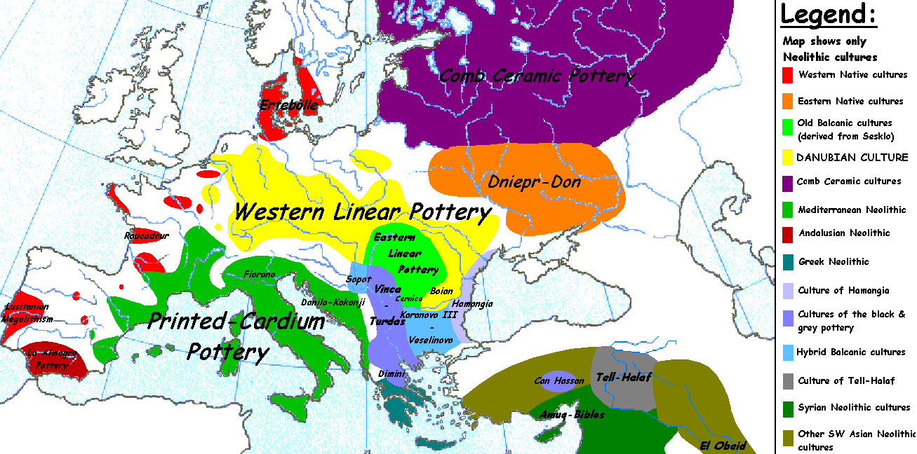
English: Map of the second half European Middle Neolithic at the apogee of Danubian and Mediterranean expansion. (The modification of the original map - Combed pottery, earlier notated as Pitted Ware, see history without respecting the color code of the legend is something that I am not fully satisfied with). |
| תאריך יצירה | 5 באפריל 2005 (תאריך העלאה מקורי) |
| מקור | הועבר מ- en.wikipedia לוויקישיתוף. |
| יוצר | Later versions were uploaded by Clarifer at en.wikipedia. |
| גרסאות אחרות |
[]
|


_en.png)
.png)
.jpg)
רישיון
| היצירה הזאת שוחררה לנחלת הכלל על־ידי היוצר שלה, Sugaar מוויקיפדיה האנגלית. זה תקף בכל העולם. יש מדינות שבהן הדבר אינו אפשרי על פי חוק, אם כך: Sugaar מעניק לכל אחד את הזכות להשתמש ביצירה הזאת לכל מטרה, ללא שום תנאי, אלא אם כן תנאים כאלה נדרשים לפי החוק. |
יומן העלאה מקורי
תיאור הקובץ המקורי נמצא כאן. כל שמות המשתמשים הבאים מתייחסים ל-en.wikipedia.
- 2005-08-28 13:11 Clarifer 1320×663×8 (106148 bytes) Added the approximate area of the Comb Ceramic culture. Source: National Board of Antiquities, Finland. www.nba.fi
- 2005-04-05 20:12 Sugaar 1320×663×8 (103228 bytes) Map of the second half European Middle Neolithic at the apogee of Danubian and Mediterranean expansion (c. 4500-4000 BCE). Made by [[Sugaar]]. Free use authorized by the author.
היסטוריית הקובץ
ניתן ללחוץ על תאריך/שעה כדי לראות את הקובץ כפי שנראה באותו זמן.
| תאריך/שעה | תמונה ממוזערת | ממדים | משתמש | הערה | |
|---|---|---|---|---|---|
| נוכחית | 09:43, 18 באפריל 2014 | | 648 × 1,307 (101 ק"ב) | Spiridon Ion Cepleanu | Neolithic shorelines and banks, little details |
| 03:39, 22 במרץ 2010 |  | 648 × 1,307 (101 ק"ב) | Ras67 | cropped | |
| 03:50, 14 בפברואר 2007 |  | 663 × 1,320 (104 ק"ב) | 32X | Auf eine alte Version zurückgesetzt | |
| 03:49, 14 בפברואר 2007 |  | 663 × 1,320 (101 ק"ב) | 32X | Original version by Sugaar. | |
| 14:14, 31 בדצמבר 2005 |  | 663 × 1,320 (104 ק"ב) | Glenn | Originally uploaded to en-wiki: Quote: "Map of the second half European Middle Neolithic at the apogee of Danubian and Mediterranean expansion (c. 4500-4000 BCE)." Upload text: "20:12, 5 April 2005 . . Sugaar . . 1320x663 (103228 bytes) (Map of the secon |
שימוש בקובץ
הדף הבא משתמש בקובץ הזה:
שימוש גלובלי בקובץ
אתרי הוויקי השונים הבאים משתמשים בקובץ זה:
- שימוש באתר az.wikipedia.org
- שימוש באתר be.wikipedia.org
- שימוש באתר bg.wikipedia.org
- שימוש באתר bs.wikipedia.org
- שימוש באתר ca.wikipedia.org
- שימוש באתר cs.wikipedia.org
- שימוש באתר da.wikipedia.org
- שימוש באתר da.wikibooks.org
- שימוש באתר de.wikipedia.org
- שימוש באתר en.wikipedia.org
- שימוש באתר et.wikipedia.org
- שימוש באתר fi.wikipedia.org
- שימוש באתר fi.wikibooks.org
- שימוש באתר gl.wikipedia.org
- שימוש באתר hi.wikipedia.org
- שימוש באתר hr.wikipedia.org
- שימוש באתר hu.wikipedia.org
- שימוש באתר it.wikipedia.org
- שימוש באתר ka.wikipedia.org