
קובץ:Eastern Frontier, Cape of Good Hope, ca 1835.png

גודל התצוגה המקדימה הזאת: 684 × 600 פיקסלים. רזולוציות אחרות: 274 × 240 פיקסלים | 548 × 480 פיקסלים | 836 × 733 פיקסלים.
לקובץ המקורי (836 × 733 פיקסלים, גודל הקובץ: 279 ק"ב, סוג MIME: image/png)
| זהו קובץ שמקורו במיזם ויקישיתוף. תיאורו בדף תיאור הקובץ המקורי (בעברית) מוצג למטה. |
תקציר
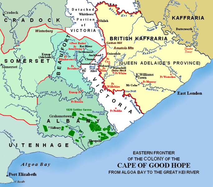
| תיאור |
(i.e. period between 5th and 8th Xhosa Wars) 1820 British settler farms in the Albany district, or eastern Zuurveld
Settled colonial area (est. 1795), showing Grahamstown (est. 1812), and districts (est. 1820) in shades of pale green
Neutral zone (est. 1820), as agreed between Lord Charles Somerset and the Gaika (Ngqika) faction of the amaXhosa.
British Kaffraria (est. 1835), incl. East London (est. 1847): Gaika faction of amaXhosa and amaTembu under British protection.
Kaffraria, incl. Butterworth Wesleyan mission (est. 1827): amaTembu living inland and amaXhosa nearer the coast.
Mountains and necks, incl. Gaika's Hill 32°32′46″S 26°57′07″E / 32.54611°S 26.95194°E in the easternmost Winterberg.
Military forts, district boundaries and eastern frontier.
Notes
|
| תאריך יצירה | Redrawn and coloured in December 2007 |
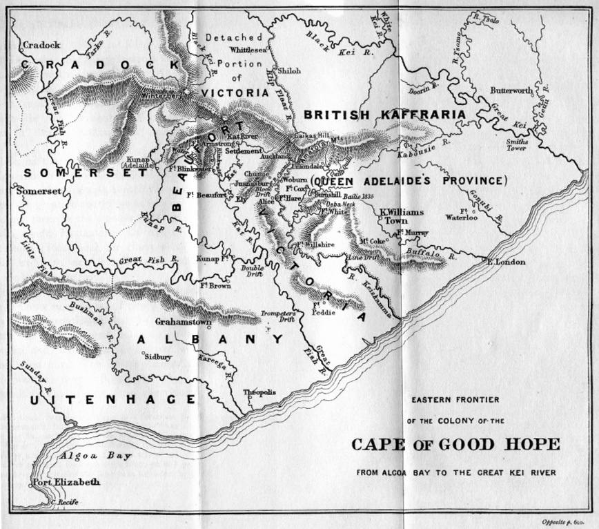
| מקור | Based on the source map below, last published in 1903. |
| יוצר | I created the map, based partly on the source map: Eastern frontier of the Colony of the Cape of Good Hope from Algoa Bay to the Great Kei river, which appears opposite page 620 of ‘The autobiography of Lieutenant-general Sir Harry Smith’ by G.C.B. Bart, Chapter xlviii, published 1903, as part of the online Build a Book initiative. JMK 11:03, 26 December 2007 (UTC) |
| גרסאות אחרות |
The original map relates to 1850 more or less, and may be John Arrowsmith's 1851 Eastern Frontier of the Colony of the Cape of Good Hope (and part of Kafirland), From Algoa Bay to the Great Kei River. Arrowsmith's lithograph was redrawn and compiled chiefly from M.S. Surveys & Sketches, communicated by Lt. Col. Mitchell late Survr. Genl. of the Colony and Captn. Wm Owen ...: _(14761876926).jpg) Compare also Arrowsmith, 1836:  |

רישיון
אני, בעל זכויות היוצרים על היצירה הזאת, מפרסם אותה בזאת תחת הרישיונות הבאים:

|
מוענקת בכך הרשות להעתיק, להפיץ או לשנות את המסמך הזה, לפי תנאי הרישיון לשימוש חופשי במסמכים של גנו, גרסה 1.2 או כל גרסה מאוחרת יותר שתפורסם על־ידי המוסד לתוכנה חופשית; ללא פרקים קבועים, ללא טקסט עטיפה קדמית וללא טקסט עטיפה אחורית. עותק של הרישיון כלול בפרק שכותרתו הרישיון לשימוש חופשי במסמכים של גנו. |
This file is licensed under the Creative Commons Attribution-Share Alike 4.0 International, 3.0 Unported, 2.5 Generic, 2.0 Generic and 1.0 Generic license.
- הנכם רשאים:
- לשתף – להעתיק, להפיץ ולהעביר את העבודה
- לערבב בין עבודות – להתאים את העבודה
- תחת התנאים הבאים:
- ייחוס – יש לתת ייחוס הולם, לתת קישור לרישיון, ולציין אם נעשו שינויים. אפשר לעשות את זה בכל צורה סבירה, אבל לא בשום צורה שמשתמע ממנה שמעניק הרישיון תומך בך או בשימוש שלך.
- שיתוף זהה – אם תיצרו רמיקס, תשנו, או תבנו על החומר, חובה עליכם להפיץ את התרומות שלך לפי תנאי רישיון זהה או תואם למקור.
הנכם מוזמנים לבחור את הרישיון הרצוי בעיניכם.
היסטוריית הקובץ
ניתן ללחוץ על תאריך/שעה כדי לראות את הקובץ כפי שנראה באותו זמן.
| תאריך/שעה | תמונה ממוזערת | ממדים | משתמש | הערה | |
|---|---|---|---|---|---|
| נוכחית | 03:57, 13 בינואר 2021 | | 733 × 836 (279 ק"ב) | JMK | add label |
| 14:41, 13 במאי 2019 |  | 733 × 836 (278 ק"ב) | JMK | Change map colour east of Great Kei River (based on comments received), as it was never part of British Caffraria. Other minor changes. | |
| 14:47, 30 בדצמבר 2007 |  | 733 × 836 (253 ק"ב) | JMK | Update | |
| 13:58, 26 בדצמבר 2007 |  | 733 × 836 (257 ק"ב) | JMK | {{Information |Description=Eastern frontier of the Colony of the Cape of Good Hope from Algoa Bay to the Great Kei river *Settled colonial area shown in green, with districts established in 1820 shown in different shades of green *Neutral zone agreed on b | |
| 13:55, 26 בדצמבר 2007 |  | 733 × 836 (257 ק"ב) | JMK | {{Information |Description=Eastern frontier of the Colony of the Cape of Good Hope from Algoa Bay to the Great Kei river *Settled colonial area shown in green, with districts established in 1820 shown in different shades of green *Neutral zone agreed on b |
שימוש בקובץ
הדף הבא משתמש בקובץ הזה:
שימוש גלובלי בקובץ
אתרי הוויקי השונים הבאים משתמשים בקובץ זה:
- שימוש באתר af.wikipedia.org
- שימוש באתר ca.wikipedia.org
- שימוש באתר de.wikipedia.org
- שימוש באתר en.wikipedia.org
- שימוש באתר eo.wikipedia.org
- שימוש באתר es.wikipedia.org
- שימוש באתר fa.wikipedia.org
- שימוש באתר fr.wikipedia.org
- שימוש באתר it.wikipedia.org
- שימוש באתר ja.wikipedia.org
- שימוש באתר mk.wikipedia.org
- שימוש באתר nl.wikipedia.org
- שימוש באתר ru.wikipedia.org
- שימוש באתר sv.wikipedia.org
- שימוש באתר uk.wikipedia.org
- שימוש באתר www.wikidata.org
- שימוש באתר xh.wikipedia.org