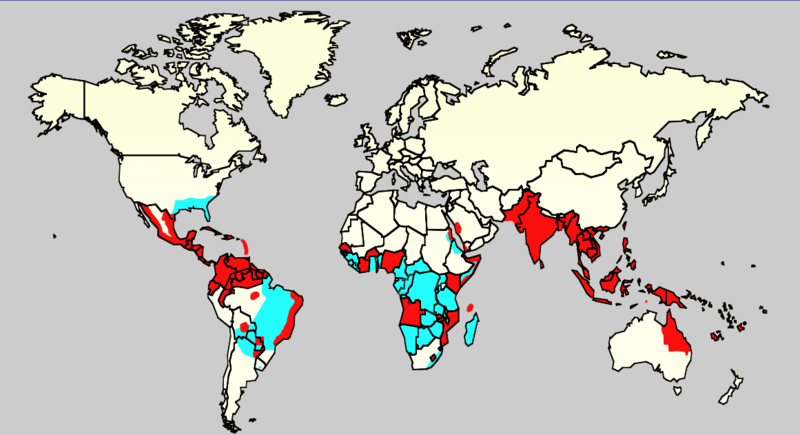
קובץ:Dengue06.png

גודל התצוגה המקדימה הזאת: 800 × 435 פיקסלים. רזולוציות אחרות: 320 × 174 פיקסלים | 640 × 348 פיקסלים | 1,161 × 631 פיקסלים.
לקובץ המקורי (1,161 × 631 פיקסלים, גודל הקובץ: 42 ק"ב, סוג MIME: image/png)
היסטוריית הקובץ
ניתן ללחוץ על תאריך/שעה כדי לראות את הקובץ כפי שנראה באותו זמן.
| תאריך/שעה | תמונה ממוזערת | ממדים | משתמש | הערה | |
|---|---|---|---|---|---|
| נוכחית | 03:14, 21 בפברואר 2016 |  | 631 × 1,161 (42 ק"ב) | Jahoe | Removed large chunk of irrelevant metadata, left behind by adobe editing software. No visible changes. |
| 19:26, 18 בדצמבר 2015 |  | 631 × 1,161 (63 ק"ב) | Splette | Remove border between East and West Germany, as it has been united since 1990 (long before 2006) | |
| 02:34, 3 ביוני 2007 |  | 631 × 1,161 (48 ק"ב) | Aetheling | Map showing the distribution of dengue fever in the world, as of 2006. Map produced by the Agricultural Research Service of the US Department of Agriculture. Source: Slide #8 of a presentation by Gary G. Clark, PhD, entitled "Dengue: An emerging arbovira |
שימוש בקובץ
הדף הבא משתמש בקובץ הזה:
שימוש גלובלי בקובץ
אתרי הוויקי השונים הבאים משתמשים בקובץ זה:
- שימוש באתר ar.wikipedia.org
- שימוש באתר arz.wikipedia.org
- שימוש באתר ast.wikipedia.org
- שימוש באתר bn.wikipedia.org
- שימוש באתר ca.wikipedia.org
- שימוש באתר cs.wikipedia.org
- שימוש באתר cy.wikipedia.org
- שימוש באתר de.wikipedia.org
- שימוש באתר el.wikipedia.org
- שימוש באתר en.wikipedia.org
- Natural hazards in Colombia
- Mosquito-borne disease
- User:Justthefacts1/Sandbox
- Dengue fever outbreaks
- Talk:Dengue fever/Archive 1
- Wikipedia:Wikipedia Signpost/2011-07-11/Featured content
- Wikipedia:WikiProject Medicine/Collaborative publication/Dengue fever
- Wikipedia:Wikipedia Signpost/2014-10-01/News and notes
- Wikipedia:Wikipedia Signpost/Single/2014-10-01
- Wikipedia:Wikipedia Signpost/Single/2011-07-11
- User:Notorious Biggles/Tobagoitis
- Wikipedia:WikiProject WikiFundi Content/Dengue fever
- שימוש באתר es.wikipedia.org
- שימוש באתר es.wiktionary.org
- שימוש באתר eu.wikipedia.org
- שימוש באתר fa.wikipedia.org
- שימוש באתר fi.wikipedia.org
- שימוש באתר fr.wikipedia.org
- שימוש באתר ga.wikipedia.org
- שימוש באתר hi.wikipedia.org
- שימוש באתר hr.wikipedia.org
- שימוש באתר hu.wikipedia.org
- שימוש באתר hu.wikibooks.org
- שימוש באתר is.wikipedia.org
- שימוש באתר it.wikipedia.org
- שימוש באתר ja.wikipedia.org
- שימוש באתר la.wikipedia.org
- שימוש באתר ml.wikipedia.org
- שימוש באתר ms.wikipedia.org
- שימוש באתר nl.wikipedia.org
- שימוש באתר no.wikipedia.org
- שימוש באתר or.wikipedia.org
- שימוש באתר pl.wikipedia.org


