קובץ:Columbia Island - aerial view 2005.jpg

תוכן הדף אינו נתמך בשפות אחרות.
מתוך ויקיפדיה, האנציקלופדיה החופשית

Columbia_Island_-_aerial_view_2005.jpg(473 × 406 פיקסלים, גודל הקובץ: 240 ק"ב, סוג MIME‏: image/jpeg)

ויקישיתוף זהו קובץ שמקורו במיזם ויקישיתוף. תיאורו בדף תיאור הקובץ המקורי (בעברית) מוצג למטה.

תקציר

תיאור
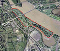
English: Aerial view of Columbia Island (outlined in red) in the Potomac River in Washington, D.C., in the United States.

Arlington Memorial Bridge enters the island from the northeast, connecting it to the Lincoln Memorial. A large memorial plaza and traffic circle, constructed in the 1930s, connects Arlington Memorial Bridge to Lee Highway, the George Washington Memorial Parkway, and the Boundary Channel Bridge. The many piers of the Columbia Island Marina jut into the Bounday Channel and Pentagon Lagoon on the southwest corner of the island.

The Potomac River runs along the island to the northwest. The Lincoln Memorial and a portion of the Tidal Basin can also be seen.

The Boundary Channel (west and southwest of the island) is part of the Potomac River. The Boundary Channel Bridge links Columbia Island to Memorial Drive and the ceremonial entrance to Arlington National Cemetery (left side of the image). The Pentagon can be seen to the bottom of the image, and just north of that its large parking lots.

Upstream (upper center portion of this image) is the Theodore Roosevelt Bridge, and Theodore Roosevelt Island. The skyscrapers of Rossyln, Virginia, can just be seen in the far upper left corner of the image.
תאריך יצירה
מקור File:Washington_77.04477W_38.88819N.jpg
יוצר NASA


Public domain קובץ זה נמצא ברשות הציבור מכיוון שהוא נוצר על ידי נאס"א. מדיניות זכויות היוצרים של נאס"א קובעת ש"חומרים של NASA אינם מוגנים בזכויות יוצרים אלא אם צוין אחרת". (דף מדיניות זכויות היוצרים ב-NASA או מדיניות שימוש בתמונות ב-JPL).
אזהרות:
  • שימוש בלוגואים, סמלים וטלאים של נאס"א כפוף להגבלה של החוק בארצות הברית 14 CFR 1221.
  • אתר האינטרנט של נאס"א מכיל תמונות רבות שמקורן מתוכנית החלל הסובייטית/סוכנות החלל הרוסית, וחומרים נוספים של סוכנויות חלל אחרות. קבצים אלו אינם בהכרח תחת רשות הציבור.
  • חומרים מטלסקופ החלל האבל עשויים להיות מוגנים בזכויות יוצרים אם לא מצוין במפורש שהגיעו מSTScI. [1]
  • כל החומרים שנוצרו על ידי חללית SOHO מוגנים בזכויות יוצרים ודורשים הרשאה עבור שימוש מסחרי לא חינוכי. [2]
  • תמונות המוצגות באתר Astronomy Picture of the Day (APOD) עשויים להיות מוגנים בזכויות יוצרים. [3]

רישיון

כיתובים

נא להוסיף משפט שמסביר מה הקובץ מייצג

פריטים שמוצגים בקובץ הזה

מוצג

image/jpeg

checksum אנגלית

1d22d2c28309637a64265673c7f24fdd50cdb821

הוגדר לפי: SHA-1 אנגלית

246,042 בית

406 פיקסל

473 פיקסל

היסטוריית הקובץ

ניתן ללחוץ על תאריך/שעה כדי לראות את הקובץ כפי שנראה באותו זמן.

תאריך/שעהתמונה ממוזערתממדיםמשתמשהערה
נוכחית21:23, 6 במאי 2013תמונה ממוזערת לגרסה מ־21:23, 6 במאי 2013‪406 × 473‬ (240 ק"ב)Tim1965{{Information |Description ={{en|1=Aerial view of Columbia Island (outlined in red) in the Potomac River in Washington, D.C., in the United States. Arlington Memorial Bridge enters the island from the northeast, connecting it to the Lincoln Memoria...

הדף הבא משתמש בקובץ הזה:

שימוש גלובלי בקובץ

אתרי הוויקי השונים הבאים משתמשים בקובץ זה:

מטא־נתונים