
קובץ:Battle of Mount Sorrel - Battle Map - June 6 (restored1).jpg

לקובץ המקורי (1,741 × 2,800 פיקסלים, גודל הקובץ: 1.94 מ"ב, סוג MIME: image/jpeg)
| זהו קובץ שמקורו במיזם ויקישיתוף. תיאורו בדף תיאור הקובץ המקורי (בעברית) מוצג למטה. |
| תיאור |
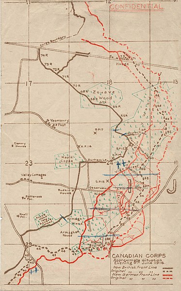
English: This map illustrates the British/Canadian positions (in brown) and the German lines (in red) on 4 June 1916, during the Battle of Mount Sorrel. The Canadians have been driven from several strong points, including Hooge north), Mount Sorrel itself (south), and most of Observatory Ridge (centre). |
|||
| תאריך יצירה | ||||
| מקור |
George Metcalf Archival Collection, Canadian War Museum: 19870027-018 [1] |
|||
| יוצר | n.d. | |||
| אישורים והיתרים (שימוש חוזר בקובץ זה) |
|
|||
| גרסאות אחרות |
 |

.jpg)
.jpg?uselang=he)
![[1]](http://www.warmuseum.ca/cwm/exhibitions/guerre/photos/2800/19870027-018.jpg)
| זוהי תמונה מרוטשת, זאת אומרת שהתמונה שונתה בצורה דיגיטלית מהמקור. Modifications: Tears, holes and major folds & creases repaired or decreased in intensity..
|
| מיקום המצלמה | | תמונה זו ותמונות נוספות במיקום: OpenStreetMap |
|---|
.jpg¶ms=050.841342_N_0002.948456_E_globe:Earth_type:camera_scale:10000_region:BE_&language=he)
היסטוריית הקובץ
ניתן ללחוץ על תאריך/שעה כדי לראות את הקובץ כפי שנראה באותו זמן.
| תאריך/שעה | תמונה ממוזערת | ממדים | משתמש | הערה | |
|---|---|---|---|---|---|
| נוכחית | 00:12, 20 בדצמבר 2009 | | 2,800 × 1,741 (1.94 מ"ב) | Labattblueboy | {{Information |Description={{en|1=This map illustrates the British/Canadian positions (in brown) and the German lines (in red) on 4 June 1916, during the Battle of Mount Sorrel. The Canadians have been driven from several strong points, including Hooge no |
שימוש בקובץ
הדף הבא משתמש בקובץ הזה:
שימוש גלובלי בקובץ
אתרי הוויקי השונים הבאים משתמשים בקובץ זה:
- שימוש באתר en.wikipedia.org
- שימוש באתר fr.wikipedia.org
- שימוש באתר nl.wikipedia.org
- שימוש באתר sk.wikipedia.org
- שימוש באתר www.wikidata.org
.jpg)