
קובץ:Balkans 6th century.svg

גודל התצוגה המקדימה הזאת מסוג PNG של קובץ ה־SVG הזה: 800 × 431 פיקסלים. רזולוציות אחרות: 320 × 173 פיקסלים | 640 × 345 פיקסלים | 1,024 × 552 פיקסלים | 1,280 × 690 פיקסלים | 2,560 × 1,381 פיקסלים | 1,400 × 755 פיקסלים.
לקובץ המקורי (קובץ SVG, הגודל המקורי: 1,400 × 755 פיקסלים, גודל הקובץ: 1.83 מ"ב)
| זהו קובץ שמקורו במיזם ויקישיתוף. תיאורו בדף תיאור הקובץ המקורי (בעברית) מוצג למטה. |
תקציר
| תיאור |
Deutsch: Die nördliche Balkanhalbinsel in der Spätantike (6. Jahrhundert), mit den spätrömischen Provinzen, Hauptsiedlungen und Straẞen.
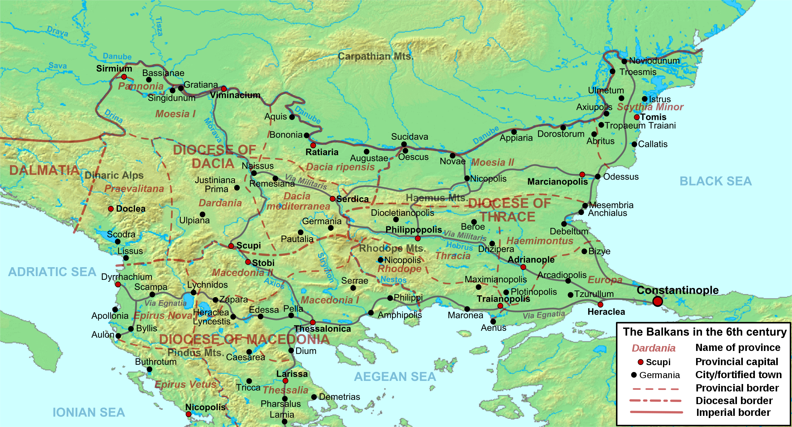
English: Map of the northern Balkans in the 6th century AD, with the Roman provinces, major settlements and roads.
Français : Carte des Balkans septentrionaux au VIe siècle, à la veille de l'arrivée des Slaves, avec les provinces romains, les villes et les routes les plus importantes. |
| תאריך יצירה | |
| מקור |
נוצר על־ידי מעלה היצירה based on:
|
| יוצר | Cplakidas |
| גרסאות אחרות |
[]
|


רישיון
אני, בעל זכויות היוצרים על היצירה הזאת, מפרסם אותה בזאת תחת הרישיונות הבאים:
הקובץ הזה מתפרסם לפי תנאי רישיון קריאייטיב קומונז ייחוס-שיתוף זהה 3.0 לא מותאם.
- הנכם רשאים:
- לשתף – להעתיק, להפיץ ולהעביר את העבודה
- לערבב בין עבודות – להתאים את העבודה
- תחת התנאים הבאים:
- ייחוס – יש לתת ייחוס הולם, לתת קישור לרישיון, ולציין אם נעשו שינויים. אפשר לעשות את זה בכל צורה סבירה, אבל לא בשום צורה שמשתמע ממנה שמעניק הרישיון תומך בך או בשימוש שלך.
- שיתוף זהה – אם תיצרו רמיקס, תשנו, או תבנו על החומר, חובה עליכם להפיץ את התרומות שלך לפי תנאי רישיון זהה או תואם למקור.

|
מוענקת בכך הרשות להעתיק, להפיץ או לשנות את המסמך הזה, לפי תנאי הרישיון לשימוש חופשי במסמכים של גנו, גרסה 1.2 או כל גרסה מאוחרת יותר שתפורסם על־ידי המוסד לתוכנה חופשית; ללא פרקים קבועים, ללא טקסט עטיפה קדמית וללא טקסט עטיפה אחורית. עותק של הרישיון כלול בפרק שכותרתו הרישיון לשימוש חופשי במסמכים של גנו. |
הנכם מוזמנים לבחור את הרישיון הרצוי בעיניכם.
היסטוריית הקובץ
ניתן ללחוץ על תאריך/שעה כדי לראות את הקובץ כפי שנראה באותו זמן.
| תאריך/שעה | תמונה ממוזערת | ממדים | משתמש | הערה | |
|---|---|---|---|---|---|
| נוכחית | 12:52, 11 במאי 2012 | | 755 × 1,400 (1.83 מ"ב) | Cplakidas | corrected locations of Thracia and Haemimontus, minor tweaks elsewhere |
| 23:27, 7 בינואר 2012 |  | 755 × 1,400 (1.91 מ"ב) | Cplakidas | Left-over names to paths | |
| 23:29, 1 במרץ 2010 |  | 755 × 1,400 (2.1 מ"ב) | Cplakidas | names to paths | |
| 23:20, 1 במרץ 2010 |  | 755 × 1,400 (1.08 מ"ב) | Cplakidas | {{Information |Description={{en|1=Map of the northern Balkans in the 6th century AD. Geophysical map taken from from [http://www2.demis.nl/mapserver/mapper.asp DEMIS Mapserver], which are public domain, other wise self-made. Sources: [http://soltdm.com/so |
שימוש בקובץ
הדף הבא משתמש בקובץ הזה:
שימוש גלובלי בקובץ
אתרי הוויקי השונים הבאים משתמשים בקובץ זה:
- שימוש באתר ar.wikipedia.org
- שימוש באתר azb.wikipedia.org
- שימוש באתר be.wikipedia.org
- שימוש באתר bg.wikipedia.org
- שימוש באתר bs.wikipedia.org
- שימוש באתר cs.wikipedia.org
- שימוש באתר de.wikipedia.org
- שימוש באתר el.wikipedia.org
- שימוש באתר en.wikipedia.org
- History of Albania
- 593
- Maurice (emperor)
- Moesia
- Dardani
- Serbia in the Middle Ages
- Pannonia (Byzantine province)
- Dacia Ripensis
- Dacia Mediterranea
- Dacia Aureliana
- Diocese of Dacia
- Praevalitana
- Peter (curopalates)
- Maurice's Balkan campaigns
- Dardania (Roman province)
- Ratiaria
- Via Militaris
- Comentiolus
- Albania under the Byzantine Empire