
קובץ:1995 Atlantic hurricane season summary map.png

גודל התצוגה המקדימה הזאת: 800 × 495 פיקסלים. רזולוציות אחרות: 320 × 198 פיקסלים | 640 × 396 פיקסלים | 1,024 × 634 פיקסלים | 1,280 × 792 פיקסלים | 2,560 × 1,585 פיקסלים | 4,000 × 2,476 פיקסלים.
לקובץ המקורי (4,000 × 2,476 פיקסלים, גודל הקובץ: 6.37 מ"ב, סוג MIME: image/png)
| זהו קובץ שמקורו במיזם ויקישיתוף. תיאורו בדף תיאור הקובץ המקורי (בעברית) מוצג למטה. |
| תיאור |
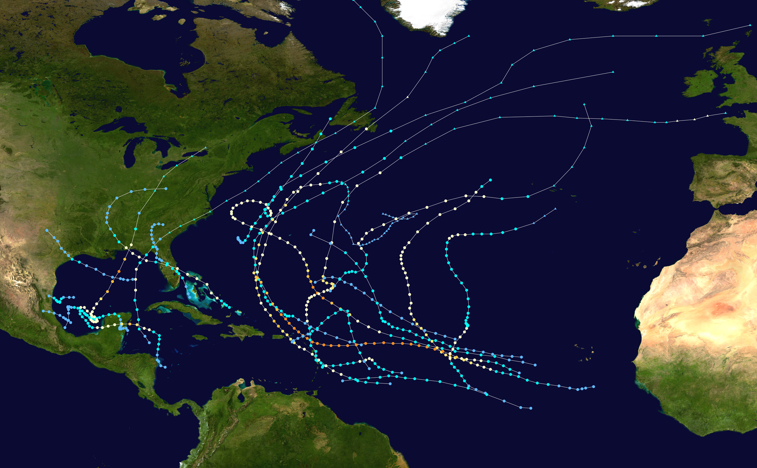
English: This map shows the tracks of all tropical cyclones in the 1995 Atlantic hurricane season. The points show the location of each storm at 6-hour intervals. The colour represents the storm's maximum sustained wind speeds as classified in the Saffir-Simpson Hurricane Scale (see below), and the shape of the data points represent the type of the storm.
Tropical depression (≤38 mph, ≤62 km/h)
Tropical storm (39–73 mph, 63–118 km/h)
Category 1 (74–95 mph, 119–153 km/h)
Category 2 (96–110 mph, 154–177 km/h)
Category 3 (111–129 mph, 178–208 km/h)
Category 4 (130–156 mph, 209–251 km/h)
Category 5 (≥157 mph, ≥252 km/h)
Unknown
Storm type |
| מקור | Created using Wikipedia:WikiProject Tropical cyclones/Tracks. The background image is from NASA [1]. The tracking data is from the National Hurricane Center's Atlantic hurricane database |
| יוצר | Supportstorm |

|
This file may be updated to reflect new information. If you wish to use a specific version of the file without new updates being mirrored, please upload the required version as a separate file. |
| היצירה הזאת שוחררה לנחלת הכלל על־ידי היוצר שלה, Supportstorm. זה תקף בכל העולם. יש מדינות שבהן הדבר אינו אפשרי על פי חוק, אם כך: Supportstorm מעניק לכל אחד את הזכות להשתמש ביצירה הזאת לכל מטרה, ללא שום תנאי, אלא אם כן תנאים כאלה נדרשים לפי החוק. |
היסטוריית הקובץ
ניתן ללחוץ על תאריך/שעה כדי לראות את הקובץ כפי שנראה באותו זמן.
| תאריך/שעה | תמונה ממוזערת | ממדים | משתמש | הערה | |
|---|---|---|---|---|---|
| נוכחית | 06:33, 28 בינואר 2020 | | 2,476 × 4,000 (6.37 מ"ב) | Supportstorm | Standard dimensions |
| 21:52, 9 ביוני 2013 |  | 1,854 × 3,000 (4.27 מ"ב) | Supportstorm | {{Hurricane season auto track map|start=|end=|source=ATL|type=hurricane|basin=Atlantic|year=1995|author=Supportstorm}} |
שימוש בקובץ
הדף הבא משתמש בקובץ הזה:
שימוש גלובלי בקובץ
אתרי הוויקי השונים הבאים משתמשים בקובץ זה:
- שימוש באתר de.wikipedia.org
- שימוש באתר en.wikipedia.org
- Hurricane Opal
- 1995 Atlantic hurricane season
- Hurricane Roxanne
- Hurricane Luis
- Hurricane Marilyn
- Hurricane Erin (1995)
- Hurricane Allison (1995)
- Template:1995 Atlantic hurricane season buttons
- Hurricane Felix (1995)
- Tropical Storm Jerry (1995)
- Hurricane Iris (1995)
- Tropical Storm Gabrielle (1995)
- Tropical Storm Dean (1995)
- Hurricane Tanya
- Timeline of the 1995 Atlantic hurricane season
- Meteorological history of Hurricane Luis
- User:TheAustinMan/sandbox/Hurricane Opal
- User:Khaled98/1995 hurricane reanalysis
- שימוש באתר es.wikipedia.org
- שימוש באתר fr.wikipedia.org
- שימוש באתר ta.wikipedia.org