
קובץ:1822 Geographical, Statistical, and Historical Map of Florida by Henry Charles Carey, Isaac Lea and Fielding Lucas.png

גודל התצוגה המקדימה הזאת: 498 × 599 פיקסלים. רזולוציות אחרות: 199 × 240 פיקסלים | 399 × 480 פיקסלים | 804 × 967 פיקסלים.
לקובץ המקורי (804 × 967 פיקסלים, גודל הקובץ: 1.39 מ"ב, סוג MIME: image/png)
| זהו קובץ שמקורו במיזם ויקישיתוף. תיאורו בדף תיאור הקובץ המקורי (בעברית) מוצג למטה. |
תקציר
| תיאור |
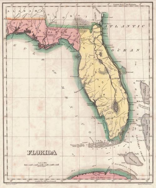
English: 1822 map of Florida Territory, published less then a year after Florida was ceded to the U.S. by Spain. The map delineates the territory's two original counties – Escambia and St. Johns, whose initial boundaries were conterminous with those of the earlier districts of East and West Florida. The interior river system is still largely anecdote and conjecture. Two roads lead west out of St. Augustine, one to Rollstown on the St. Johns River and the other to Ivitachua. A number of early northern forts are listed, including Ft. Barancas, Ft. Gadsden or Collinton, Ft. St. Marks, Ft. Poppa, Picolota Ft., and a British Fort erected during the war on the Apalachicola River. |
| תאריך יצירה | |
| מקור |
Original publication: A Complete Historical, Chronological, And Geographical American Atlas, Being A Guide To The History Of North And South America, And The West Indies ... To The Year 1822. According To The Plan Of Le Sage's Atlas And Intended As A Companion To Lavoisne's Improvement Of That Celebrated Work." (Philadelphia, PA: Carey and Lea, 1822) |
| יוצר |
Henry Charles Carey, Isaac Lea, Fielding Lucas |
- Other information
English: This is an image of an original map that is in the public domain. This image is not a derivative work of the original map, as it has not been improved through techniques such as cutting out backgrounds, fixing broken lines, simplification, sharpening or otherwise cleaning up.
רישיון
This work is in the public domain in the United States because it was published (or registered with the U.S. Copyright Office) before January 1, 1929.
Public domain works must be out of copyright in both the United States and in the source country of the work in order to be hosted on the Commons. If the work is not a U.S. work, the file must have an additional copyright tag indicating the copyright status in the source country.
Note: This tag should not be used for sound recordings. |
היסטוריית הקובץ
ניתן ללחוץ על תאריך/שעה כדי לראות את הקובץ כפי שנראה באותו זמן.
| תאריך/שעה | תמונה ממוזערת | ממדים | משתמש | הערה | |
|---|---|---|---|---|---|
| נוכחית | 16:16, 30 בינואר 2016 | | 967 × 804 (1.39 מ"ב) | Jeff in CA | re-cropped image |
| 13:40, 30 בינואר 2016 |  | 984 × 830 (1.82 מ"ב) | Jeff in CA | {{subst:Upload marker added by en.wp UW}} {{Information |Description = {{en|One of the earliest obtainable separate maps of Florida following its admission as a Territory in July 1821, the map pre-dates all but St. John's County, with the only delineat... |
שימוש בקובץ
הדף הבא משתמש בקובץ הזה:
שימוש גלובלי בקובץ
אתרי הוויקי השונים הבאים משתמשים בקובץ זה:
- שימוש באתר ar.wikipedia.org
- שימוש באתר bn.wikipedia.org
- שימוש באתר br.wikipedia.org
- שימוש באתר en.wikipedia.org
- שימוש באתר es.wikipedia.org
- שימוש באתר et.wikipedia.org
- שימוש באתר gl.wikipedia.org
- שימוש באתר mt.wikipedia.org
- שימוש באתר pt.wikipedia.org
- שימוש באתר sr.wikipedia.org
- שימוש באתר tr.wikipedia.org
- שימוש באתר vi.wikipedia.org